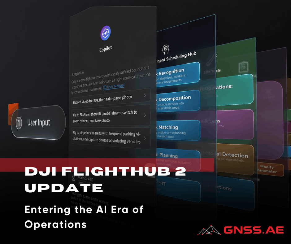
Limitation of Drone Mapping in Desert Environments
Introduction Drone mapping workflows—whether they rely on photogrammetry, LiDAR, or a mix of both—are usually built on a few key

Introduction Drone mapping workflows—whether they rely on photogrammetry, LiDAR, or a mix of both—are usually built on a few key

Introduction Drone mapping workflows used to be built around relatively predictable environments: open terrain, stable GNSS conditions, and surfaces with

Introduction: From Visual Inspections to Data-Driven Interpretation Traditional inspection models were built around fixed cycles: fly, capture, review, repeat. Nowadays,

Inspection Workflows as Multi-Stage Systems In many drone inspection projects, the flight itself often takes center stage. But in reality,

Introduction: The Idea of a Single-Flight Workflow In drone mapping projects, LiDAR and photogrammetry have traditionally been treated as two

Introduction Real-time kinematic (RTK) positioning has significantly improved drone mapping and already offers higher efficiency than traditional ground-based survey methods.

Introduction On many industrial sites, the environment is harder on the drone than the flight itself. A drone inspecting conveyors

Understanding GNSS Accuracy Metrics Global Navigation Satellite Systems (GNSS) determine positions by measuring distances between a receiver and multiple satellites.

Introduction For oil and gas operators, the main hurdle isn’t gathering more data anymore. It’s about getting to the right

Introduction For many geophysical projects, the main difficulty is not collecting magnetic data but actually getting where you want to

Introduction The application of drone-based gas detection has expanded beyond emergency responders and research initiatives. Today, utility operators, landfill owners,

Introduction DJI recently introduced DJI Reality v1.0.0 as a free application for opening and presenting large 3D survey models. However,

Introduction DJI has officially introduced DJI Reality v1.0.0 — a new desktop application designed for viewing, presenting, and navigating large-scale

Introduction Bridges are some of the most important—and challenging—pieces of infrastructure to maintain. Every day, they are exposed to traffic

Introduction The rapid advancement of unmanned aerial systems has reshaped how organizations handle physical security. What once belonged mostly to

Introduction As drone delivery technology keeps advancing, the need for smooth coordination and control is becoming just as crucial as

Introduction Multispectral imaging has become an essential part of modern UAV workflows. It allows professionals to go beyond simple visual

Introduction to DJI FlyCart The rapid evolution in drone logistics is reshaping how industries manage cargo delivery, particularly in remote

Introduction to Pix4D Pix4D is an established developer of photogrammetry and drone mapping software widely adopted in sectors such as

In collaboration with the DJI AERONEX regional team, GNSS.AE recently conducted field testing of the DJI Zenmuse L3 LiDAR payload

Introduction Enterprise drone programs are changing quickly. Nowadays, inspection teams, emergency responders, surveyors, and utility operators are looking for more

GNSS.AE is proud to announce its official recognition as an authorized DJI Enterprise Partner, received during the DJI AERONEX Summit

Oblique aerial imaging has become a fundamental component of modern aerial photogrammetry. Unlike traditional nadir imaging, which captures the Earth’s

A practical guide for professional drone operations From flying drones to delivering usable geospatial data The commercial UAV market has

From its early beginnings as the Global Positioning System (GPS) to today’s advanced multi-constellation GNSS receivers, satellite-based positioning has transformed

The renewable energy sector is expanding at an unprecedented pace, with wind and solar installations rapidly spreading across remote and

Today’s agricultural sector faces increasingly complex challenges. Farmers worldwide must balance productivity with sustainability amid climate change, rising global food

In the rapidly evolving field of geospatial technology, selecting the right software solution is critical for project success. In this

The launch of DJI Zenmuse L3 marks a significant new chapter in DJI’s professional LiDAR payload lineup. Building on the

Aerial multispectral imaging has fundamentally reshaped how we assess crops, ecosystems, and environmental change. At the center of this evolution

DJI has officially launched DJI FlyCart 100, marking a significant leap forward in heavy-lift cargo drone technology. As the company’s

Across multiple industries, drone technology has reshaped how professionals collect data, conduct surveys, and monitor the environment. What once felt

As utilities modernize their infrastructure and accelerate digital transformation, UAV-based inspections have become a cornerstone of safe and efficient power

Topographic surveys are essential across commercial real estate, construction, and infrastructure development. These projects demand exceptional precision, full situational awareness,

As modern GIS workflows increasingly depend on centimeter-level accuracy, a solid understanding of geodetics has become essential for professionals working

On November 26, GNSS.AE had the pleasure of welcoming our partner SHAREUAV to our Dubai office for an exclusive technology

Gamma-ray spectrometry has become an indispensable tool for environmental science, mining, agritech, and contamination assessment. By measuring the energy and

Across the GCC region, spanning the UAE, Oman, and now Saudi Arabia, drone technology is rapidly reshaping how organisations acquire,

How can cities optimise infrastructure? How do businesses understand customer behaviour through location data? How can governments map and respond

Successful aerial mapping and surveying begin long before the drone leaves the ground. While flying may seem as simple as