Wildlife monitoring often involves covering large and difficult-to-access areas while keeping disturbance to a minimum. Ground surveys can take considerable time, while manned aircraft are expensive and are not always practical for repeated surveys.
Drones offer another option. They can collect detailed aerial data repeatedly, use thermal and other specialized sensors, and reach areas that are difficult to survey from the ground.
In this article, we look at how UAVs are being used to count and track wildlife, study animal behaviour, monitor habitats and human-wildlife conflict, and collect data for AI-based analysis. We’ll also look at where drones have clear limitations, including the risk of disturbing the animals they are meant to protect.
One of the most established applications of UAVs in conservation is population monitoring.
Aerial imagery can cover an entire colony, herd, wetland, or other survey area while preserving a detailed spatial record of where animals were detected. Researchers can use this data to count individuals, estimate group sizes, compare different locations, and repeat surveys over time.
A study of grey seal colonies in eastern Canada provides a good example. Researchers combined fixed-wing UAS imagery, thermal sensors, and GIS-based processing to detect and count individual seals. The workflow also helped distinguish adults from young animals and separate individual seals in densely populated areas.
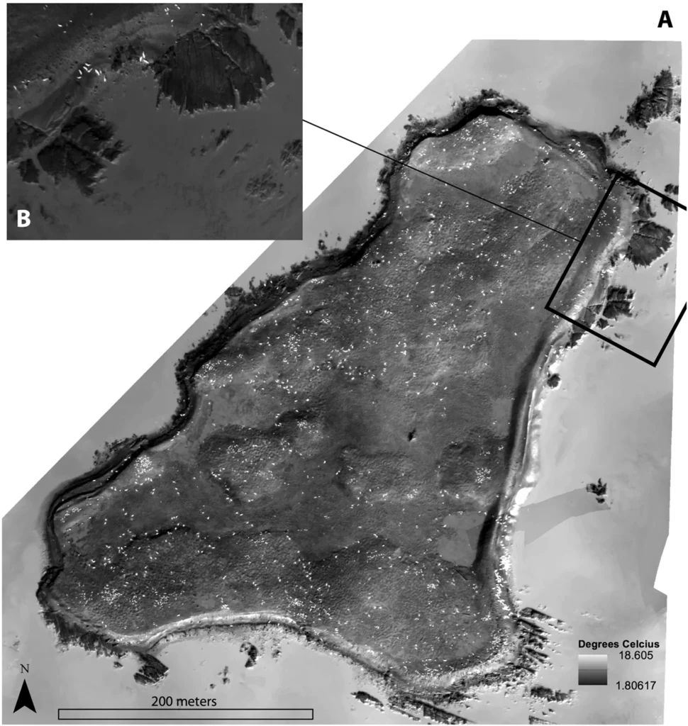
Thermal cameras can reveal animals that are difficult to distinguish in conventional RGB imagery. Differences in heat can make an animal stand out against cooler vegetation, soil, or water, particularly in low-light conditions.
In a drone survey of orangutans, for example, the animals were clearly visible in thermal imagery but difficult to distinguish in the corresponding RGB footage. At a flight height of 100 m, one confirmed orangutan could be identified in the thermal image while remaining almost indistinguishable in the optical image.
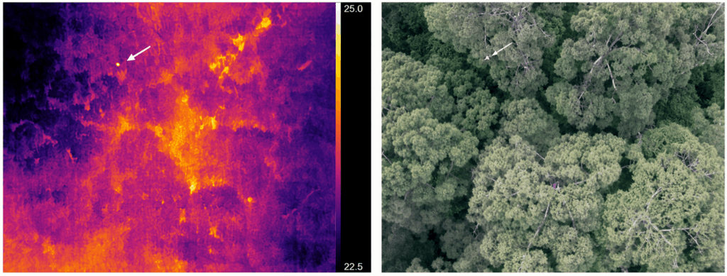
Thermal imagery is not, however, a standalone species-identification method. Thermal signatures vary between flights, individuals, and environmental conditions, so the data is better treated as an additional source of information.
Its usefulness depends on the species, habitat, weather, time of day, and temperature difference between the animal and its surroundings. For nocturnal wildlife or animals that are difficult to see in vegetation, thermal data can significantly improve aerial surveys.
Drone video can be used to study movement, group formation, social interactions, activity patterns, and responses to environmental conditions. A consistent aerial viewpoint allows researchers to observe these behaviours without moving through the same space as the animals.
In a 2025 study, researchers from Save the Elephants and the University of Oxford conducted 35 drone trials involving 14 known elephant families in Kenya’s Samburu and Buffalo Springs National Reserves. They recorded the elephants’ behavioural responses to the aircraft and examined whether those responses changed with repeated exposure.
The results were encouraging, but they also showed why it is difficult to simply describe drones as “non-invasive.” Elephants initially reacted to the aircraft in some trials, but these responses decreased within minutes. Nearly half of the trials showed no detectable disturbance.
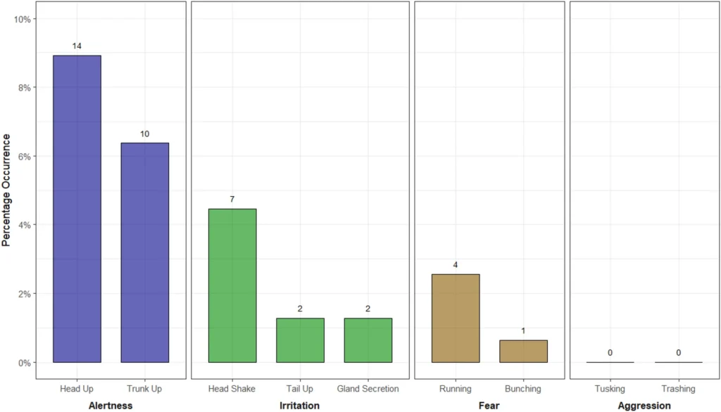
This is important for behavioural studies because the observation method itself can affect the behaviour being measured. If animals consistently react to the drone, it becomes harder to determine whether the recorded behaviour reflects normal activity.
A wildlife survey can produce thousands of images, but the photographs are only the starting point. The next step is turning them into spatial data that can be measured, compared, and revisited.
Mapping and photogrammetry software can convert aerial imagery into orthomosaics, 3D models, point clouds, and terrain data. Thermal cameras can provide additional information about animal presence or activity, while multispectral sensors can help assess vegetation and habitat conditions. Tools such as DJI Terra, Pix4Dmapper, Agisoft Metashape, and 3Dsurvey can process these datasets into georeferenced outputs for further analysis.
This allows researchers to map animal observations, assess the surrounding habitat, and compare the same area across repeated surveys.
AI can further automate parts of this workflow by detecting animals, counting individuals, or flagging areas for closer inspection. Even without fully automated wildlife recognition, consistent data collection and processing can make drone surveys more useful for long-term ecological monitoring.
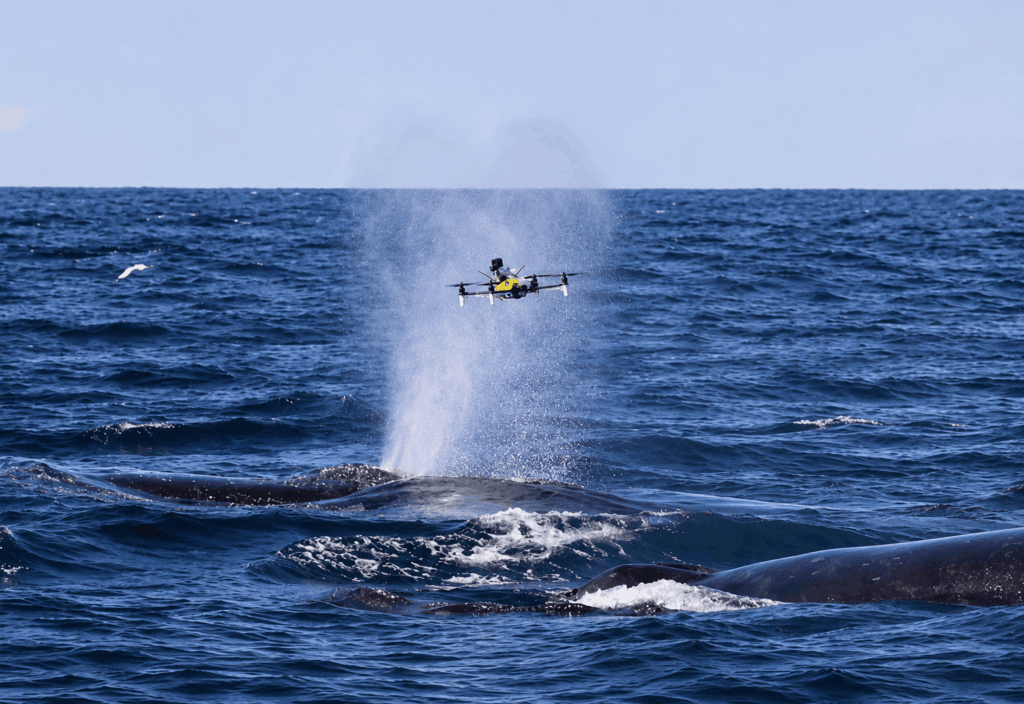
Wildlife conservation often requires information about the environment as well as the animals living in it. Drones can carry specialized payloads to collect physical samples or measure environmental conditions that are difficult to assess with standard aerial imagery.
Equipment | What it collects | Potential conservation applications |
Physical water samples | Water quality monitoring, pollution assessment, aquatic ecosystems | |
Hyperspectral data | Water quality, vegetation and forest monitoring, soil and ecosystem assessment | |
Dual-frequency acoustic data | Shallow-water bathymetry, river and lake surveys, underwater habitat mapping | |
Dual-frequency acoustic data | Bathymetry, sediment and underwater environment surveys |
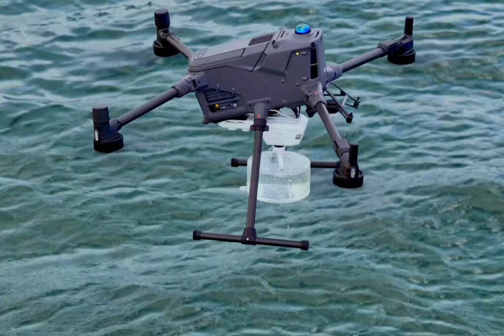
The Speedip V2 can collect physical water samples rather than relying only on remote sensing. Mounted on a compatible DJI enterprise drone, it can take samples at predefined locations and depths, with a maximum sampling depth of 10 m and a sample volume of up to 2 L. The system includes depth control, a downward-facing camera, mmWave radar, rope-tangling detection, and an emergency release mechanism.
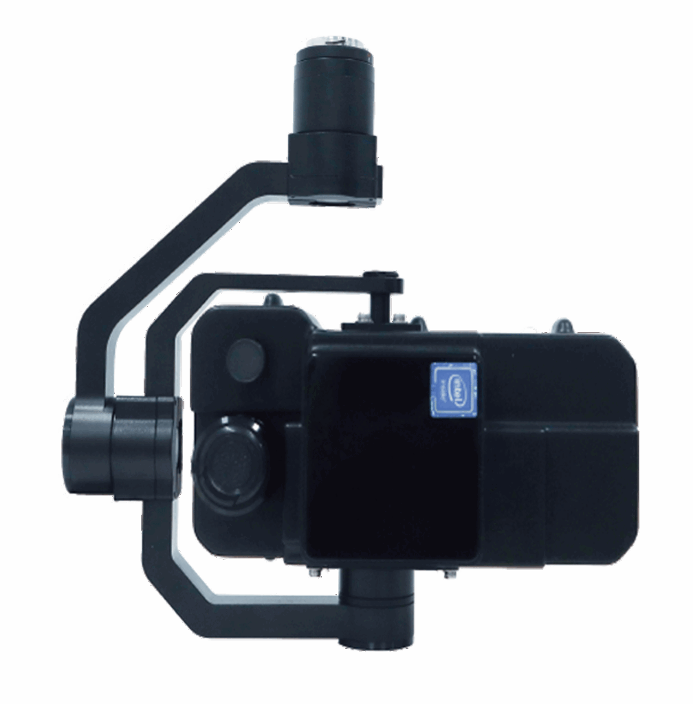
When physical sampling is not required, hyperspectral imaging can provide additional information about environmental conditions. The CHN FS6B covers the 400–2500 nm range across the VIS-NIR and SWIR bands and is designed for applications including water quality monitoring, soil analysis, forestry, and ecological monitoring. Its measurements can reveal spectral differences that are not visible in conventional RGB imagery.
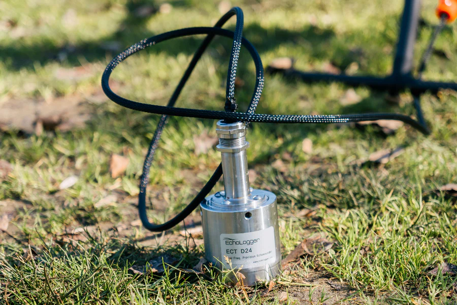
Underwater surveys require a different type of sensor. The ECT D24S and ECT D052S are dual-frequency echo sounders designed for integration with DJI enterprise drones. The D24S operates at 200/450 kHz and is suited to shallow ponds, lakes, and rivers. The D052S uses 50/200 kHz, combining depth measurement with greater penetration into soft sediments.
Wildlife data becomes much more useful when it can be linked to the environment.
An animal count by itself says little about why animals are using a particular area. A georeferenced UAV survey can add information about the surrounding habitat:
High-resolution RGB imagery can be processed into orthomosaics and other spatial products, while thermal and multispectral sensors provide additional information about environmental conditions.
Repeated UAV surveys also make it possible to compare the same area over time and track changes in both habitat and wildlife distribution.
This puts animal observations into context: not just where wildlife was found, but what the surrounding environment looked like at the time.
Wildlife conservation also means managing situations where animals come into contact with human infrastructure.
Railways, roads, farms, settlements, and other developments can create recurring conflict zones. In these cases, the most useful output from a drone may be an alert rather than a map.
Thermal imaging is well suited to this type of monitoring. It can detect animals in low-light conditions and make them easier to distinguish from the surrounding landscape.
Similar systems are also being deployed from fixed locations. In India’s Bandipur Tiger Reserve, forest authorities have introduced AI-enabled thermal cameras to monitor wildlife movement, with elephants among the main targets. The system is designed to support early detection, reduce human-wildlife conflict, and help field teams respond more quickly.
A UAV-based system can follow the same basic workflow:
detect → locate → alert → dispatch a response team
In this setup, the drone becomes part of an operational conservation system rather than simply a tool for collecting survey data.
Drones are becoming more useful in wildlife conservation as new sensors and data-processing tools become available. The same UAV platform can carry RGB, thermal, multispectral, hyperspectral, LiDAR, or other payloads depending on the task. The resulting data can be turned into maps, 3D models, measurements, environmental datasets, and targeted observations.
A single monitoring workflow can therefore combine several of these capabilities. A conservation team might survey a large area, identify locations that need closer inspection, collect additional data with another sensor, and compare the results with previous surveys or GIS datasets.
Automation can reduce the amount of manual work involved. Object detection, image classification, automated mapping, and other computer-vision methods can help process large datasets and identify areas that require further attention. As these tools improve, UAVs may also help determine where additional data collection is most useful.
The technology still has practical limitations. Flight regulations, weather, battery life, sensor performance, and the risk of disturbing wildlife all affect how drones can be used. Effective conservation work therefore depends on appropriate mission planning, equipment, and operating procedures as much as on the aircraft itself.
The best drone system is not necessarily the one with the most advanced sensor or highest-resolution camera. It is the one that produces reliable data for a specific conservation task, can be deployed repeatedly, and fits into the existing workflow of researchers and field teams.
For wildlife conservation, that is where UAVs provide their most practical value: bringing aerial observation, environmental sensing, mapping, and field data collection into the same workflow.
Yes. Thermal cameras can operate in darkness, making them useful for nocturnal wildlife surveys. However, weather, vegetation, animal behaviour, and the temperature difference between the animal and its surroundings can affect detection.
Yes. Specialized payloads allow drones to collect physical samples as well as remote-sensing data. For example, the Speedip V2 drone-based water sampling system can collect water from predefined locations and depths for subsequent laboratory analysis.
Common payloads include RGB cameras, thermal cameras, multispectral and hyperspectral sensors, LiDAR, and specialized environmental equipment such as water samplers and echo sounders. The choice depends on whether the mission focuses on animals, vegetation, terrain, water, or habitat conditions.
Battery life, weather, flight regulations, sensor performance, vegetation cover, animal behaviour, and the risk of disturbance can all limit drone surveys. Data processing and validation can also require significant time and specialist expertise.
There is no single best drone for every wildlife survey. A compact thermal drone such as the DJI Matrice 4T or Mavic 3 Thermal can be a practical choice when portability, flight time, and minimal equipment are priorities. Larger platforms such as the Matrice 400 make more sense when a project requires heavier or multiple payloads, such as LiDAR, thermal cameras, hyperspectral sensors, or environmental sampling equipment.
Yes, provided the aircraft supports the required payload and the combined weight remains within its limits. For example, larger DJI enterprise platforms can be configured for different sensors and specialized equipment. A Matrice 400 can therefore serve as a common platform for aerial observation, mapping, thermal surveys, and certain environmental sampling tasks.