Water sampling across the Gulf region is becoming both more important and more difficult.
Environmental teams are expected to monitor larger areas more frequently, often across industrial coastlines, reservoirs, wastewater systems, and remote infrastructure sites. At the same time, many sampling locations remain difficult — and sometimes unsafe — to access using traditional field methods.
This is one of the reasons UAV-based water sampling systems such as Speedip V2+ are gaining attention. Instead of sending personnel directly to the water source, operators can collect physical samples remotely using drone-based deployment workflows.
Across the UAE, Saudi Arabia, Oman, and neighboring Gulf countries, environmental monitoring programs continue to expand alongside coastal development, desalination infrastructure, industrial facilities, and large-scale water management projects.
For field teams, however, access is often the biggest challenge. Sampling operations may involve steep coastal structures, tidal zones, unstable embankments, contaminated water, marshlands, offshore infrastructure, or remote inland reservoirs — frequently under extreme heat conditions.
Traditional collection methods still rely heavily on boats or direct personnel access. In practice, this can increase preparation time, operational cost, and safety exposure for field crews.
UAV-based sampling changes that workflow entirely. Rather than bringing personnel to the sampling point, the drone carries the collection system directly to the target location and returns the sample to the operator.

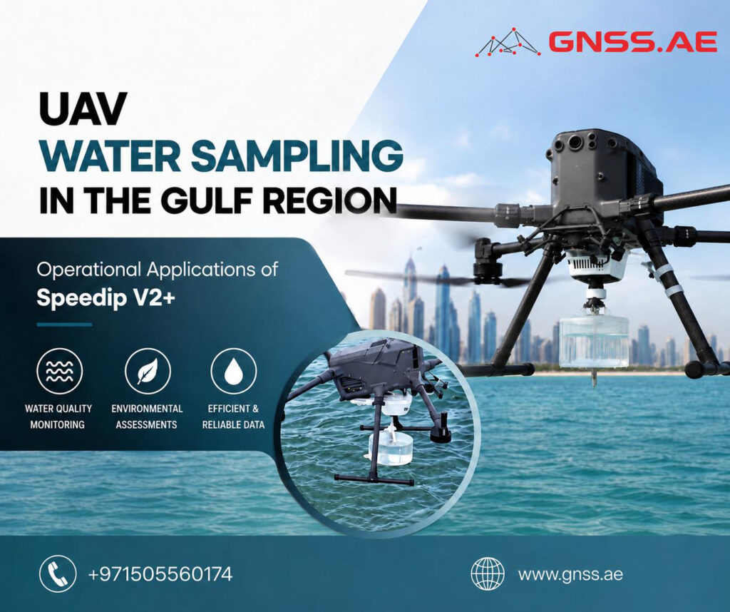
The AIRINS Speedip V2+ is a UAV-based water sampling system designed for collecting physical liquid samples in locations that are difficult, hazardous, or operationally inefficient to access using traditional field methods.
Mounted on UAV platforms such as the DJI Matrice 400 and other compatible systems, the payload enables operators to collect water samples at predefined coordinates and controlled depths without direct contact with the water body.
In practice, Speedip V2+ is used across environmental monitoring programs, industrial inspections, emergency response missions, and recurring sampling operations where conventional access may require boats, restricted site entry, unstable terrain navigation, or additional safety procedures.
At the core of the system is a controlled, repeatable sampling mechanism. The motion control logic dynamically adjusts the descent and retrieval speed of the sampling container depending on the operational stage, ensuring smooth water entry, stable depth positioning, and improved consistency of collected samples across repeated missions.
Speedip V2+ integrates onboard sensing and monitoring functions to support stable operation in real field conditions. A mm-wave radar system and downward-facing camera provide environmental awareness during deployment, helping operators maintain control in complex or low-visibility scenarios.
These systems are designed to support safe operation during BVLOS-style workflows and improve situational understanding during approach, descent, and retrieval phases


One of the main operational risks in UAV-based water sampling is rope instability during deployment and retrieval. Speedip V2+ addresses this through continuous rope tension and tangling detection.
The system monitors cable behavior in real time and alerts the operator if abnormal conditions occur, including potential entanglement or unintended ground contact.
If the sampling container becomes trapped, an emergency release mechanism allows the UAV to detach the rope and return safely.
When integrated with compatible DJI platforms, Speedip V2+ supports fully automated waypoint missions.
Operators can perform the complete workflow — takeoff, flight to the sampling point, controlled collection, and return — within a single automated mission sequence, helping reduce field workload and improve repeatability.


Four types of sampling containers are available, including PMMA and stainless-steel variants. These allow adaptation to different environmental conditions and analytical requirements, including standard water sampling and chemically sensitive applications.
Specification | Speedip V2+ |
Supported UAV Platforms | |
Maximum Sampling Depth | Up to 10 m |
Maximum Sampling Volume | Up to 2 L |
Main Body Weight | ~540–750 g depending on configuration |
Mission Type | Fully autonomous waypoint sampling |
Integrated Sensors | mm-wave radar, downward-facing camera |
Safety Functions | Rope tangling detection, grounding detection, emergency rope release |
Container Options | PMMA and stainless-steel containers |
Typical Applications | Environmental monitoring, industrial inspection, emergency response, aquatic research |
In many environmental and industrial projects across the Gulf region, the biggest challenge is simply reaching the sampling location safely and efficiently.
Depending on the site, even a routine mission can involve marine transport, shoreline access coordination, additional safety procedures, or temporary restrictions around active industrial operations. Under extreme heat and difficult terrain conditions, the process quickly becomes resource-intensive.
UAV-based sampling changes the workflow entirely. Instead of sending personnel directly to the water source, operators deploy the sampling system remotely using a drone platform.
What previously required boats, climbing access, or extended field deployment can often be completed from a nearby launch position.
The operational benefits go beyond time savings alone. Remote sampling helps reduce personnel exposure to hazardous environments, minimizes disruption at industrial sites, and makes recurring monitoring programs easier to standardize across multiple inspection cycles.
For environmental teams managing long-term monitoring projects, repeatability is particularly important. Samples can be collected at consistent coordinates and depths over time, helping create more reliable datasets for trend analysis and regulatory reporting.

One of the main applications of UAV-based water sampling across the Gulf region is recurring environmental monitoring in coastal and industrial areas.
Environmental agencies, utility operators, and industrial facilities often need repeated sampling around desalination plants, industrial discharge zones, wastewater infrastructure, ports, retention ponds, and coastal protection areas. Many of these locations are difficult to access consistently due to shallow water, restricted marine zones or active industrial operations.
Using a UAV-based workflow significantly reduces that dependency on physical access. Operators can collect samples remotely while maintaining repeatable coordinates and controlled sampling depths across recurring inspection cycles.
For a broader perspective on how UAV technologies are used in environmental monitoring beyond physical sampling, see our article on advanced aerial sensing for ecosystem and environmental assessment.
Expanding Precision in Environmental and Agricultural Monitoring: Introducing the RedEdge-P Green
Emergency response is another area where UAV-based water sampling can provide a major operational advantage.
During contamination incidents, environmental teams often need to collect samples immediately before pollutants disperse, water conditions change, or affected areas become difficult to access.
Traditional deployment methods may require boats, safety coordination, or additional mobilization time before personnel can safely reach the site. With a UAV-based system, sampling can begin much faster.
According to operational examples published by AIRINS, a mission that traditionally required around 40 minutes by boat was completed in less than 8 minutes using Speedip V2+.
In time-sensitive environmental incidents, that reduction in deployment time can significantly improve the value and reliability of the collected samples.
Despite advances in remote sensing technologies such as multispectral and hyperspectral water analysis, physical water sampling remains a core requirement in many environmental monitoring programs. Regulatory and industrial workflows still rely on laboratory-based validation, where direct samples are needed for chemical analysis, contamination verification, biological assessment, PFAS detection, and formal compliance documentation.
In this context, UAV-based systems such as Speedip V2+ are not positioned as a replacement for sensor-based methods, but as an enabler of reliable physical sampling in environments where access is limited, unsafe, or operationally inefficient. With stainless steel container options and configurations designed for PFAS-sensitive workflows, the system helps preserve sample integrity while reducing contamination risks during collection and retrieval.
This shift directly addresses key operational constraints: reducing field logistics complexity, standardizing repetitive sampling tasks and improving access to remote or hazardous locations.
As environmental compliance and water management requirements continue to expand across industrial, coastal, and inland systems, UAV-integrated sampling solutions such as Speedip V2+ are becoming an increasingly practical part of modern field operations.