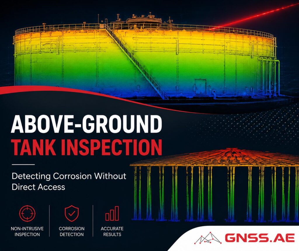
Above-ground storage tanks are among the most important assets in oil and gas operations. Many remain in service for several decades, storing crude oil, refined products, chemicals, and other materials that require ongoing inspection and maintenance to ensure safe operation.
One of the greatest threats to tank integrity is corrosion. If not identified early, corrosion can lead to wall thinning, coating deterioration, leaks, and expensive repairs. Detecting these issues is not always straightforward. Large tanks often contain areas that are difficult to access, requiring personnel to work at height and rely on scaffolding, rope access systems, or other temporary infrastructure.
This article explores how drone inspections support corrosion assessment, improve inspection efficiency, and help create digital records that can be used to monitor asset condition over time.

Storage tanks are designed to remain in service for decades, making inspection planning a demanding task. Large diameters, tall tank walls, fixed or floating roofs, and extensive piping and support systems create numerous areas that are difficult to assess from ground level.
The challenge is particularly evident when working with aging infrastructure. Halo Robotics CEO Eli Mosel described a project involving one of Indonesia’s largest crude oil storage tanks. Operators needed to evaluate the condition of the tank shell before defining the scope of a major maintenance program. Because repair and replacement decisions can involve substantial costs, obtaining reliable condition data was an essential first step.
One of the key questions in projects like this is where detailed inspections should be focused. Examining every accessible surface manually can require significant time, labor, and access equipment, especially at facilities that contain multiple tanks and other large assets. As Mosel explained, operators often need a way to identify potential problem areas before deploying specialized inspection techniques or committing resources to large-scale maintenance work.
To support this process, many companies are integrating remote inspection technologies into their asset management workflows. These tools help teams quickly assess overall tank condition, prioritize areas for further investigation, and make maintenance decisions based on more comprehensive field data.
High-resolution RGB cameras allow inspectors to evaluate large sections of a tank from a safe distance while maintaining a detailed view of critical components.
Modern zoom cameras can capture close-up imagery of tank shells, roof structures, access platforms, piping connections, foam chambers, and other external features without requiring inspectors to physically approach the asset.
This visual data can reveal a variety of conditions, including:

Because imagery is collected digitally, inspection teams can review findings after the flight, compare observations with previous surveys, and document changes over time.
For large facilities, this approach also enables more frequent inspections, helping maintenance teams identify emerging issues before they develop into larger problems.

Visual inspection remains a fundamental part of tank assessment, but many developing issues cannot be identified through visible signs alone.
Thermal cameras complement visual surveys by revealing temperature differences across a structure. These variations may indicate changes in insulation performance, moisture intrusion, product level effects, or other conditions that influence how heat is transferred through the tank.
In storage tank inspections, thermal surveys are commonly used to identify anomalies that deserve closer examination. Localized hot or cold spots can highlight areas where protective coatings have degraded, moisture has accumulated, or structural conditions differ from those of surrounding sections.
While thermal imaging cannot directly measure corrosion or determine wall thickness, it can help inspectors identify where additional testing should be performed. This allows non-destructive testing methods such as ultrasonic thickness measurements to be applied more strategically rather than across large areas of the asset.
By narrowing the scope of detailed inspections, thermal data helps inspection teams focus resources more effectively while reducing the amount of manual access required.
A practical example of this approach comes from the assessment of a 66,000 m³ crude oil storage tank in Indonesia. According to the project team, the asset was the second-largest tank of its type in the country and was scheduled for a major overhaul.
Before defining the maintenance scope, operators needed reliable information about the tank’s actual condition and the likely extent of repairs. Historical records offered only limited support, as the available as-built documentation dated back to the early 1970s. As is often the case with aging infrastructure, decades of modifications and repairs made it difficult to rely solely on archived drawings and reports.

The inspection combined high-resolution visual imagery, thermal data, and 3D spatial modeling. Drone surveys were used to examine the tank shell, foam chambers, and associated piping, allowing engineers to identify visible signs of deterioration and document the condition of external components.
Thermal imaging provided additional insight into temperature distribution across the structure and helped engineers evaluate areas that warranted closer investigation. Combined with the visual and spatial data, the results delivered a comprehensive view of the asset before maintenance work began.
The project also produced updated digital records that can support future inspections, maintenance planning, and long-term condition monitoring throughout the asset’s operational life.

Beyond immediate inspection results, many operators are increasingly interested in creating long-term digital records of critical infrastructure.
LiDAR scanning and photogrammetric modeling make it possible to generate accurate three-dimensional representations of storage tanks and surrounding facilities. These models serve as a reference point for future inspections and maintenance activities.
When inspections are repeated over time, new datasets can be compared with previous surveys to identify structural changes, monitor modifications, and maintain a historical record of asset condition.
For aging infrastructure, this historical perspective can be particularly valuable. Maintenance teams gain access to a continuously updated record of the asset, supporting planning decisions and improving coordination between operators, engineering teams, and contractors.
As digital asset management becomes more widely adopted across the oil and gas sector, these datasets are increasingly becoming part of broader integrity management and digital twin workflows.

Once field data has been collected, the focus shifts to processing and organizing the information for analysis. In the referenced project, point cloud data was processed in CloudCompare, where LiDAR datasets were cleaned, filtered, and visualized before further interpretation.
This step plays an important role in improving data quality. Raw point clouds often contain noise, reflections, and incomplete returns, particularly in industrial environments with dense piping, structural steel, and complex geometries. Processing helps remove these artifacts and produces a more accurate 3D representation of the asset.
A range of software platforms can be used for this work depending on project requirements. Photogrammetry datasets are commonly processed in applications such as Agisoft Metashape and DJI Terra, which generate orthomosaics, dense point clouds, and 3D models from overlapping aerial imagery.
For LiDAR-based projects, platforms such as Lidar360 provide tools for point cloud classification, segmentation, measurement, and feature extraction. DJI Modify can also be used to refine 3D models before visualization, analysis, or reporting.
A more detailed overview of DJI Modify, including its key features and use cases in 3D model editing and post-processing workflows, is available in one of our previous articles: DJI Modify in Practice: Where It Fits — and Where It Doesn’t
Maintaining the integrity of above-ground storage tanks requires reliable information about asset condition, especially in areas that are difficult to access using conventional methods.
Drone-based inspection workflows provide a practical way to collect visual, thermal, and spatial data while reducing the need for extensive access equipment and prolonged work at height. High-resolution imagery helps identify visible signs of deterioration, thermal surveys highlight areas that deserve closer attention, and 3D models create a valuable record for future inspections.
Combined with established non-destructive testing methods, these technologies help inspection teams focus resources where they are needed most and support more informed maintenance decisions throughout the lifecycle of the asset.