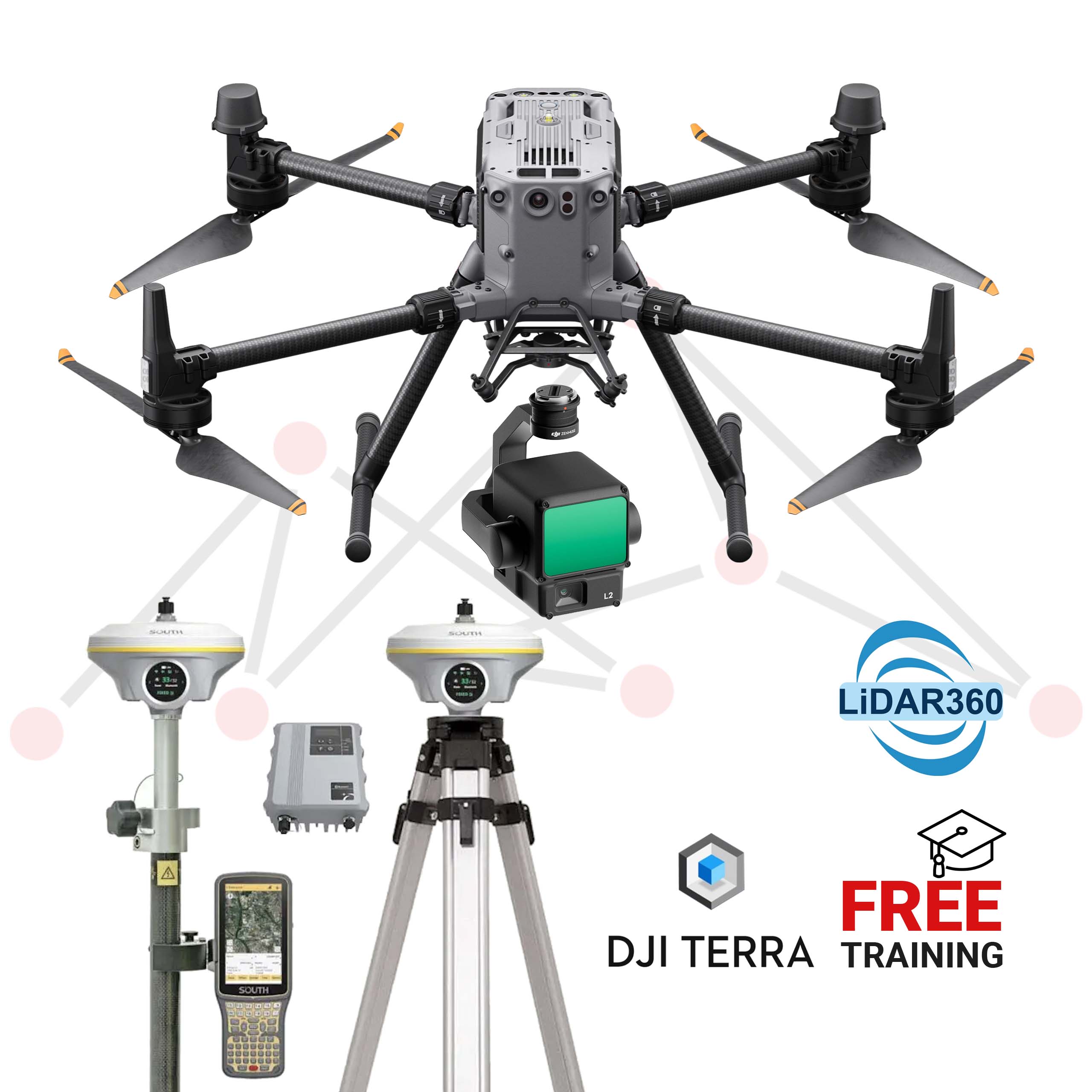
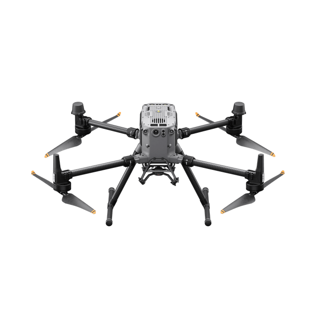
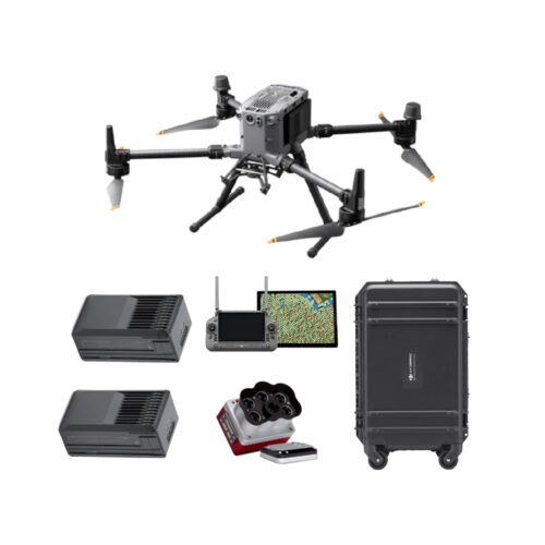
An upgraded flagship drone platform, the Matrice 350 RTK sets a new benchmark for the industry. This next-generation drone platform features an all-new video transmission system and control experience, a more efficient battery system, and more comprehensive safety features, as well as robust payload and expansion capabilities. It is fully powered to inject innovative strength into any aerial operation.


Built tough, the Matrice 350 RTK features powerful propulsion, enhanced protection rating, and excellent flight performance, allowing it to effortlessly tackle a wide variety of challenges.
55 mins
Max Flight Time
IP55
Protection Rating
2.7 kg
Max Payload
7000 m
Max Flight Altitude
12 m/s
Max Wind Speed Resistance
-20° to 50° C
Operating Temperature
Matrice 350 RTK adopts DJI O3 Enterprise Transmission, which supports triple-channel 1080p HD live feeds, [5] and a max transmission distance of 20 km. [6] Both the aircraft and the remote controller have a four-antenna transceiver system, which can intelligently select the two optimal antennas to transmit signals, while the four antennas receive signals simultaneously. In this way, anti-interference capabilities are significantly improved, and transmission stability is optimized.
The O3 video transmission signal can also work in tandem with 4G networks.* In cases where the O3 video transmission signal is interfered with, the Matrice 350 RTK can still maintain stable video transmission via 4G network, effortlessly handling signal obstructions in complex urban structures and environments.
* To use 4G Enhanced Transmission, the aircraft must be equipped with the Matrice 350 RTK 4G Dongle Kit (sold separately), and the remote controller must be equipped with the DJI Cellular Dongle (sold separately) or connected to the internet via Wi-Fi. This service is not available in some countries and regions. Please consult your local dealer for details.
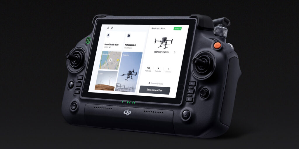
Equipped with a 7-inch high-bright screen, DJI RC Plus supports Dual Operator Mode and comes with a standard WB37 external battery that offers an operating time of up to six hours, meeting various operation needs.

IP54 rated, [2] DJI RC Plus is dustproof and waterproof to operate reliably in bad weather. The operating temperature is -20° to 50° C (-4° to 122° F), supporting around-the-clock operation even in severely hot or cold environments.
There are several buttons and dials on the front, back, and top of the remote controller for fast operation. Button functions can be customized to fit users’ habits and deliver an intuitive and flexible experience.
The DJI Pilot 2 app has been further optimized to clearly present the mission type and flight status. Easy and smooth control of the aircraft and payloads facilitates more efficient operation.
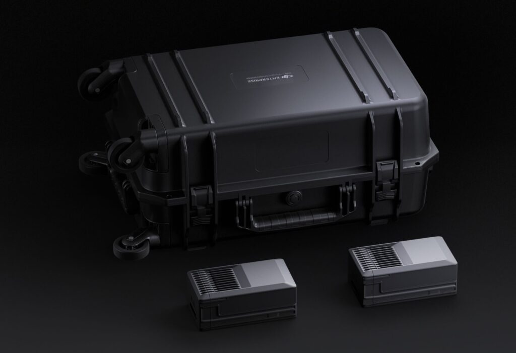
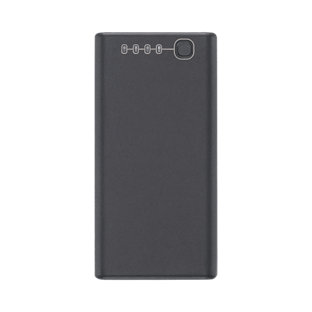
The Matrice 350 RTK is equipped with a new TB65 dual-battery system, which supports battery hot swapping and allows for multiple flights without powering off. The battery can be charged up to 400 cycles, [3] reducing the cost of a single flight.
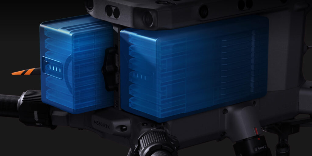
In Storage Mode, charge the battery to 50%, which is good for long-term storage. In Ready-to-Fly Mode, quickly charge multiple battery sets to 90% to start operation at any time and extend the battery life.
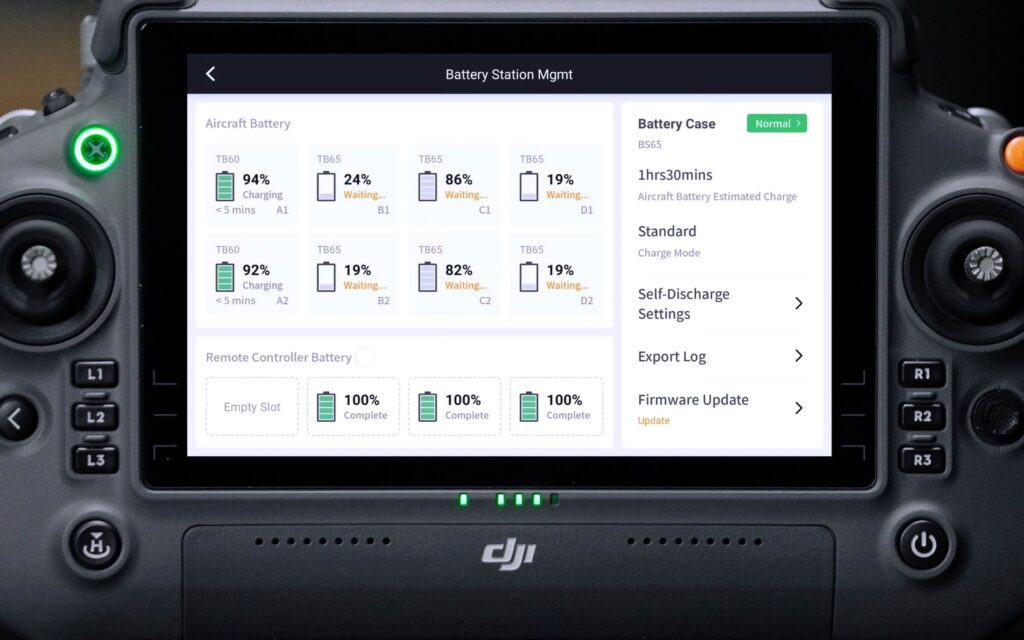
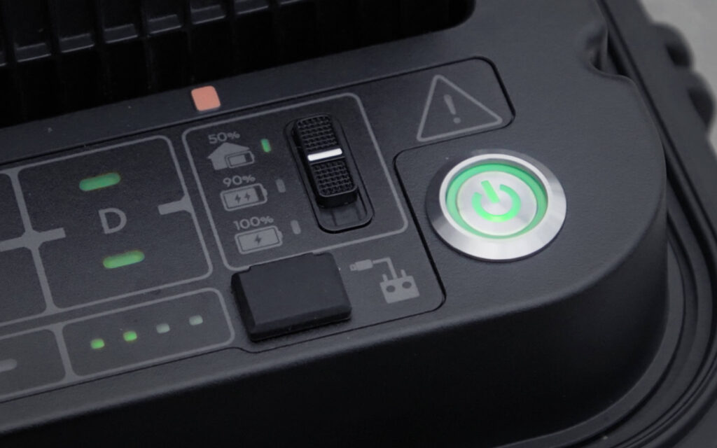
When the battery station is connected to DJI RC Plus, the DJI Pilot 2 app will display the battery status and health information. In addition, you can set the number of self-discharge days, update the firmware, export logs, and access other quick operations with one tap.
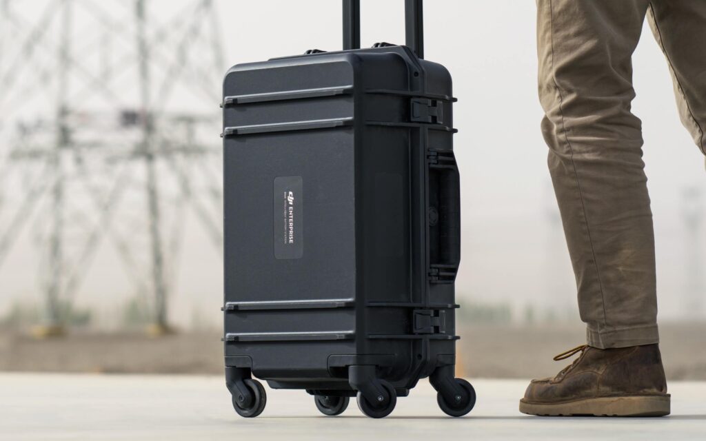
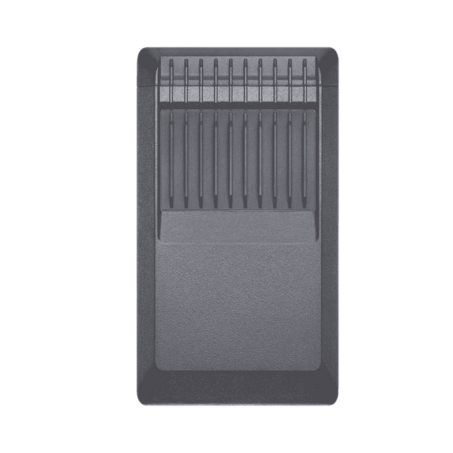
The battery station is designed with 360°-movement wheels for more convenient transportation and transitions.
With the CSM Radar installed, Matrice 350 RTK can detect subtle obstacles upward or within the horizontal 360° range and avoid them in time. [9] The effective detection range is up to 30 m, [10] further improving flight safety.
Thanks to its excellent night vision capabilities, the FPV camera can clearly present the surroundings and obstacles during flight at night. It works in tandem with the PinPoint function to provide better navigation for safe flight, assisting in more confident operation at night.
The Matrice 350 RTK is designed with a six-directional binocular vision system and an infrared sensing system for six-directional awareness, positioning, and obstacle-sensing capabilities, providing comprehensive protection during flight. [7]
The Matrice 350 RTK is designed with a six-directional binocular vision system and an infrared sensing system for six-directional awareness, positioning, and obstacle-sensing capabilities, providing comprehensive protection during flight. [7]
Both the aircraft system and the sensor system of the Matrice 350 RTK adopt a redundancy design to maximumly ensure flight safety, allowing you to cope with harsh operating environments more confidently
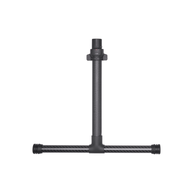
The Matrice 350 RTK supports a single downward gimbal, dual downward gimbals, [11] and a single upward gimbal, [11] and can carry three payloads simultaneously. The aircraft also has an E-Port open interface and a max payload capacity of 2.7 kg, meeting the needs of different operation scenarios like public safety, inspection, and mapping.
The spotlight offers high brightness and long illumination distance, and supports multiple lighting modes, ideal for public safety, emergency rescue, inspection, and other nighttime operations.
The speaker boasts high volume and long broadcast distance, and supports multiple broadcast modes, ideal for scenarios like public safety, emergency rescue, and more.
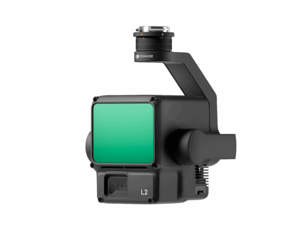
Zenmuse L2 integrates frame LiDAR, a self-developed high-accuracy IMU system, and a 4/3 CMOS RGB mapping camera, providing DJI flight platforms with more precise, efficient, and reliable geospatial data acquisition.
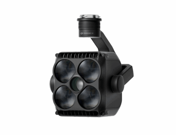
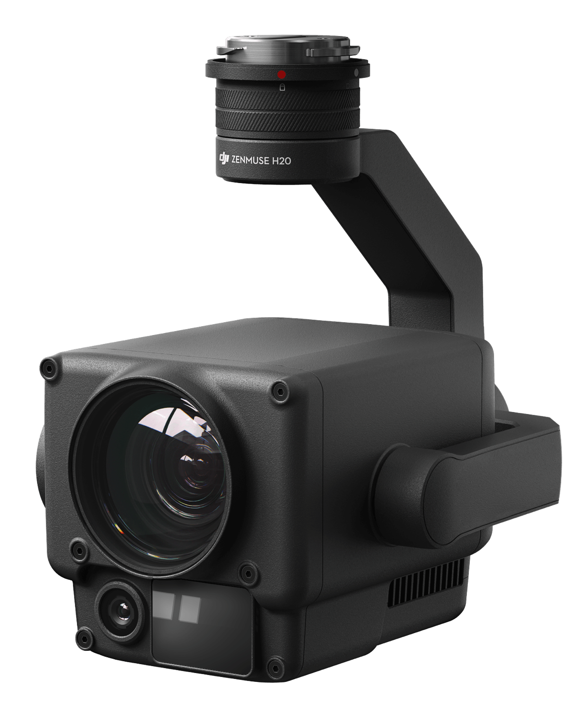
The all-weather, multi-sensor flagship Zenmuse H30 Series integrates five major modules—a wide-angle camera, a zoom camera, an infrared thermal camera, a laser range finder, and an NIR auxiliary light.
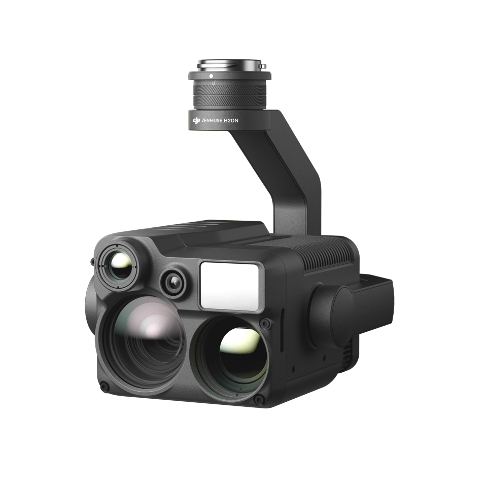
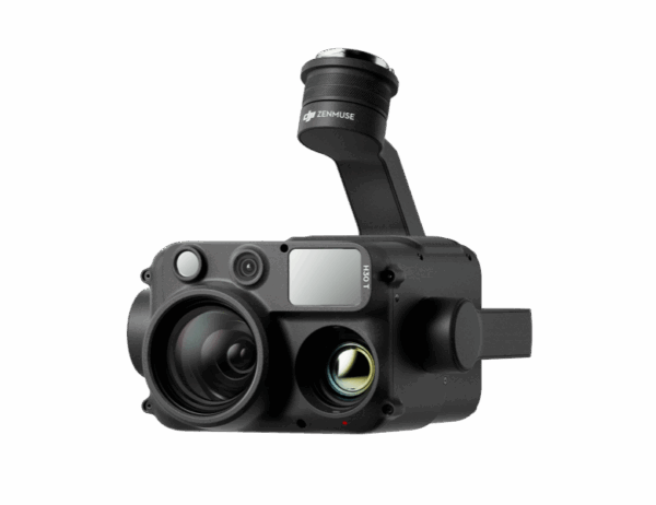
Zenmuse H20N integrates starlight sensors into its zoom and wide-angle cameras. Pair this with dual zoom thermal cameras and a laser rangefinder, and you have a versatile hybrid payload that rises to imaging performance.
The four-sensor system of zoom camera, wide camera, thermal camera, and laser rangefinder works together, supplemented by advanced intelligent algorithms, to deliver outstanding sensing and imaging performance.
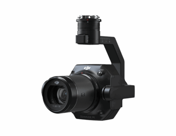
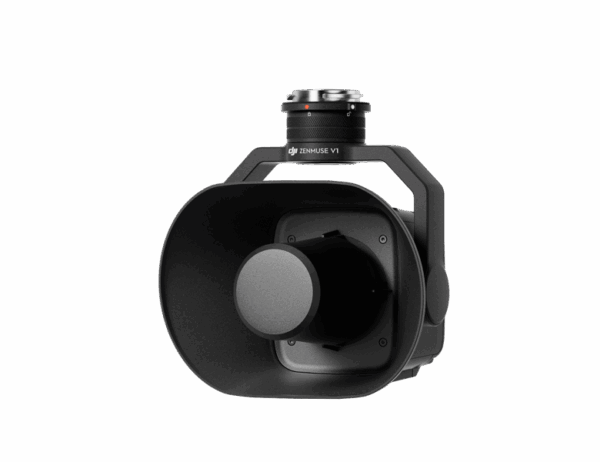
Zenmuse P1 integrates a full-frame sensor with interchangeable fixed-focus lenses on a 3-axis stabilized gimbal. Designed for photogrammetry flight missions, it takes efficiency and accuracy to a whole new level.
Customized payloads like gas detectors, loudspeakers, and multispectral sensors can be combined with Matrice 350 RTK through DJI Payload SDK to expand application fields.
Matrice 350 RTK supports Waypoint, Mapping, Oblique, and Linear Flight missions. You can use Terrain Follow [12] or Smart Oblique [13] for efficient data collection. Together with DJI Terra, you can quickly obtain HD 2D and 3D digital results, enabling high-precision and high-efficiency mapping operation.
With functions like the high-precision PinPoint and cloud-based real-time mapping, [14] the Matrice 350 RTK can link the air, ground, and cloud together. After the aircraft completes image collection, DJI FlightHub 2 can quickly model the operation site and transmit command information to the aircraft and ground operators. Both the remote controller and FlightHub 2 support point, line, surface drawing, and real-time uploading, and can cooperate with the aircraft to livestream the real-time operation view, breaking through communication barriers for air-to-ground collaborative operation.
Through Live Mission Recording, the Matrice 350 RTK can generate and store flight route files that can be used at any time to realize automated operation and make repetitive inspection no longer time-consuming or effort-consuming. When using AI Spot-Check, [15] the Matrice 350 RTK supports automatic framing and manual adjustment of subjects to improve the accuracy of repeated shooting and the quality of inspection operation.
Estimate your Matrice 350 RTK flight time based on the payload configuration.


Zenmuse L2 integrates frame LiDAR, a self-developed high-accuracy IMU system, and a 4/3 CMOS RGB mapping camera, providing DJI flight platforms with more precise, efficient, and reliable geospatial data acquisition. When used with DJI Terra, it delivers a turnkey solution for 3D data collection and high-accuracy post-processing.

Vertical Accuracy: 4 cm;
Horizontal Accuracy: 5 cm

2.5 km2 covered in a single flight

Smaller laser spots, denser point clouds

250m @10% reflectivity, 100klx
450m @50% reflectivity, 0klx


L2 can detect from 250 meters at 10% reflectivity and 100 klx, [3] and up to 450 meters at 50% reflectivity and 0 klx. [3] The typical operational altitude now extends up to 120 meters, notably enhancing operational safety and efficiency.
With a reduced spot size of 4×12 cm @100m, only a fifth of that of L1, L2 not only detects smaller objects with more details, but can also penetrate denser vegetation, generating more accurate digital elevation models (DEM).
In densely vegetated areas, L2 can capture more ground points beneath the foliage.
In both single and multiple return modes, L2 can reach a max point cloud emission rate of 240,000 points per second, allowing the acquisition of more point cloud data in a given time frame.
L2 supports two scanning modes, offering flexibility for users based on their task demands. In repetitive scanning mode, L2’s LiDAR can achieve more uniform and accurate point clouds while meeting high-precision mapping requirements. In non-repetitive scanning mode, it offers deeper penetration for more structural information, making it suitable for power line inspection, forestry surveying, and other scenarios.
The frame-based design results in an effective point cloud data rate of up to 100%. Together with a three-axis gimbal, it brings more possibilities to surveying scenarios.
The high-accuracy self-developed IMU system, combined with the drone’s RTK positioning system for data fusion during post-processing, gives L2 access to highly accurate absolute position, speed, and attitude information. In addition, the IMU system’s enhanced environmental adaptability improves the operational reliability and precision of L2.
Real-time: 0.2°, post-processing: 0.05°
Real-time 0.05°, post-processing 0.025°
The performance of the IMU system has been significantly enhanced, and it is ready for use the moment it’s powered on. And, the accompanying drone is ready to begin tasks immediately once the RTK is in FIX status, delivering an optimized in-the-field experience.
Pixel size has been enlarged to 3.3 μm, and effective pixels now reach 20 MP, resulting in a significant improvement in overall imaging, as well as more enriched true-color point cloud details. The minimum photo interval has been reduced to 0.7 seconds. The mapping camera has a shutter count of up to 200,000 times, further reducing operational costs. When point cloud collection is not needed, the RGB camera can still take photos and videos, or collect images for visible light mapping.
Supports Waypoint, Area, and Linear Route types, for handling surveying tasks in a variety of environments.
During operation, DJI Pilot 2 supports three display modes – RGB, point cloud, and point cloud/RGB side-by-side display, presenting operational results in an intuitive way. Activating RNG (Laser Rangefinder) enables access to the distance information between the LiDAR module and the object in the center of the FOV, enhancing flight safety. It also supports four real-time point cloud coloring modes – Reflectivity, Height, Distance, and RGB.
After the operation, the 3D point cloud model can be viewed directly in the album. 3D Point cloud models of multiple flights can also be merged, enabling on-site decision-making regarding operational quality.
After point cloud data collection, the DJI Pilot 2 app will automatically generate a Task Quality Report so that operators can check operational results in real-time and on-site, making fieldwork more responsive and worry-free.
In complex operational environments, users can set up RTK base stations before the operation to preemptively avoid the loss of RTK data due to interference, video transmission disconnection, or other issues. After the operation, import original files into DJI Terra to use the PPK (post-processing kinematic) process to rebuild high-precision models.
Achieve efficient and reliable one-stop post-processing when importing point cloud data into DJI Terra. Generate a standard-format 3D point cloud model with just a click after point cloud trajectory calculation and accuracy optimization. Upon ground point classification, using Ground Point Type, a DEM can be output. Point cloud quality can be analyzed with the Accuracy Control and Check function.
In coordination with DJI Enterprise flight platforms and DJI Terra, Zenmuse L2 can be applied to land surveying and mapping, electricity, forestry, and infrastructure management, as well as other scenarios.
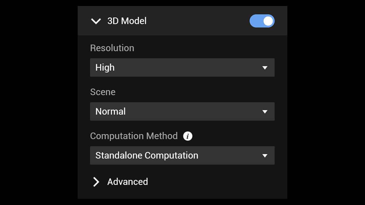
DJI Terra is 3D model reconstruction software that has photogrammetry as its core technology. It supports a range of accurate and efficient 2D and 3D reconstruction of visible light, and data processing through DJI LiDAR.
DJI Terra is a perfect match for DJI Enterprise drones and payloads. It works in conjunction to build a complete application solution that caters to verticals such as land surveying and mapping, power transmission, emergency services, construction, transportation, and agriculture.
400 photos/1GB
(single computer)
6,000 photos/1GB
(cluster processing)
30,000 photos/3 days
(single computer)
30,000 photos/21 hours
(cluster processing)
400 photos/1GB
(single computer)
6,000 photos/1GB
(cluster processing)
5,000 photos/2 hours
(single computer)
5,000 photos/80 minutes
(cluster processing)
A simple and intuitive interface that gets you flying in no time.
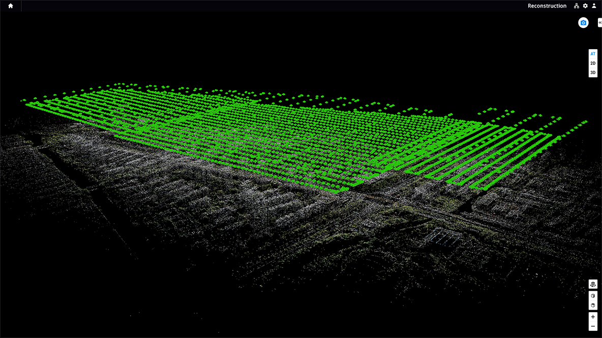
Run reconstruction missions by employing multiple graphics cards simultaneously to improve efficiency.
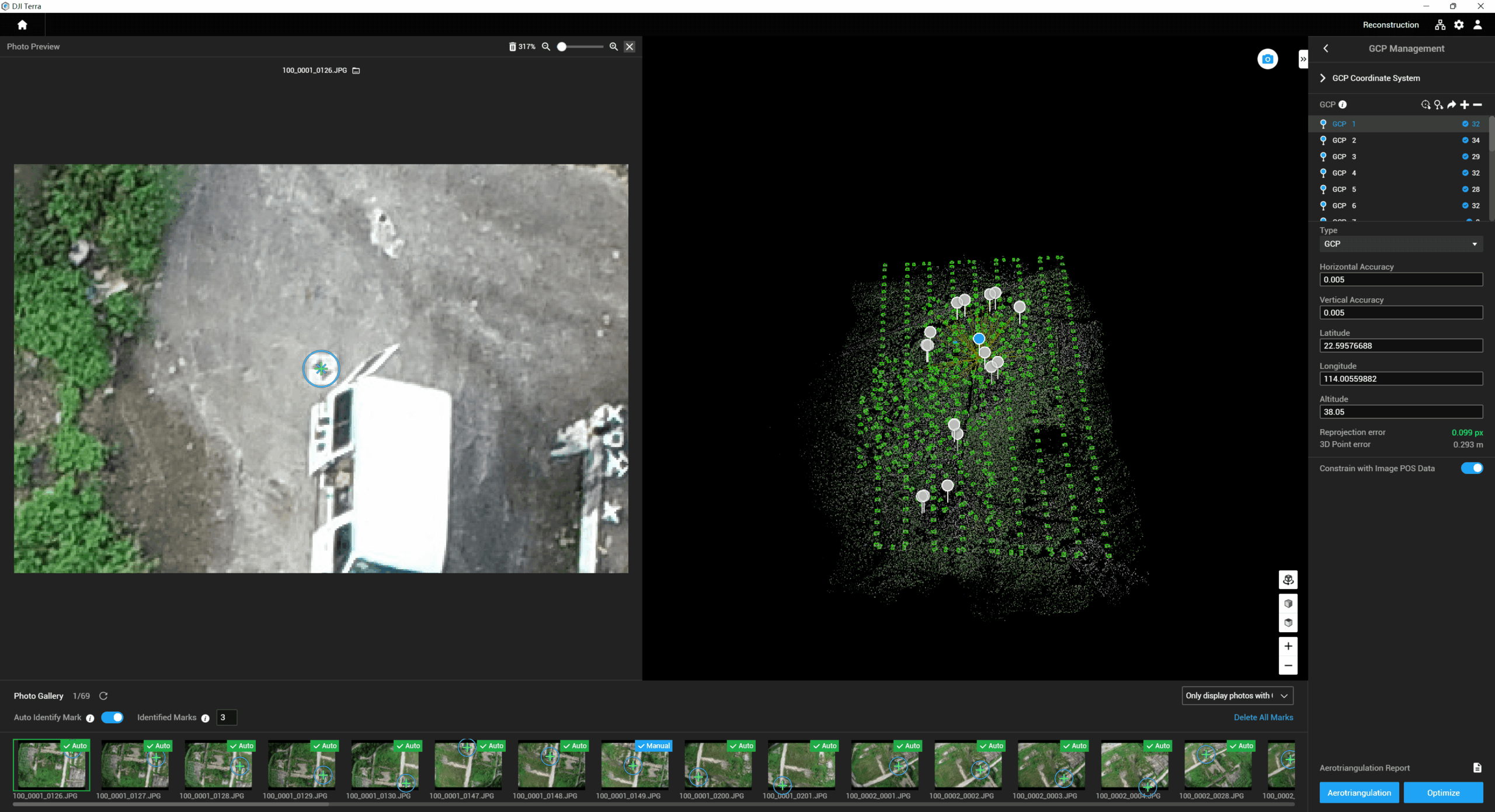
Incorporate POS data, GCPs, or both sets of data to create georeferenced maps and models with enhanced accuracy directly in the target coordinate system required by the project.
Convert the coordinates of your maps and models into 8500+ major coordinate systems by simply selecting the output that fits your needs.
View a quality report of your mission to ensure the results meet your accuracy standards.
Support the auto GCPs for automatic identification of more photos with marking points by simply marking one photo.
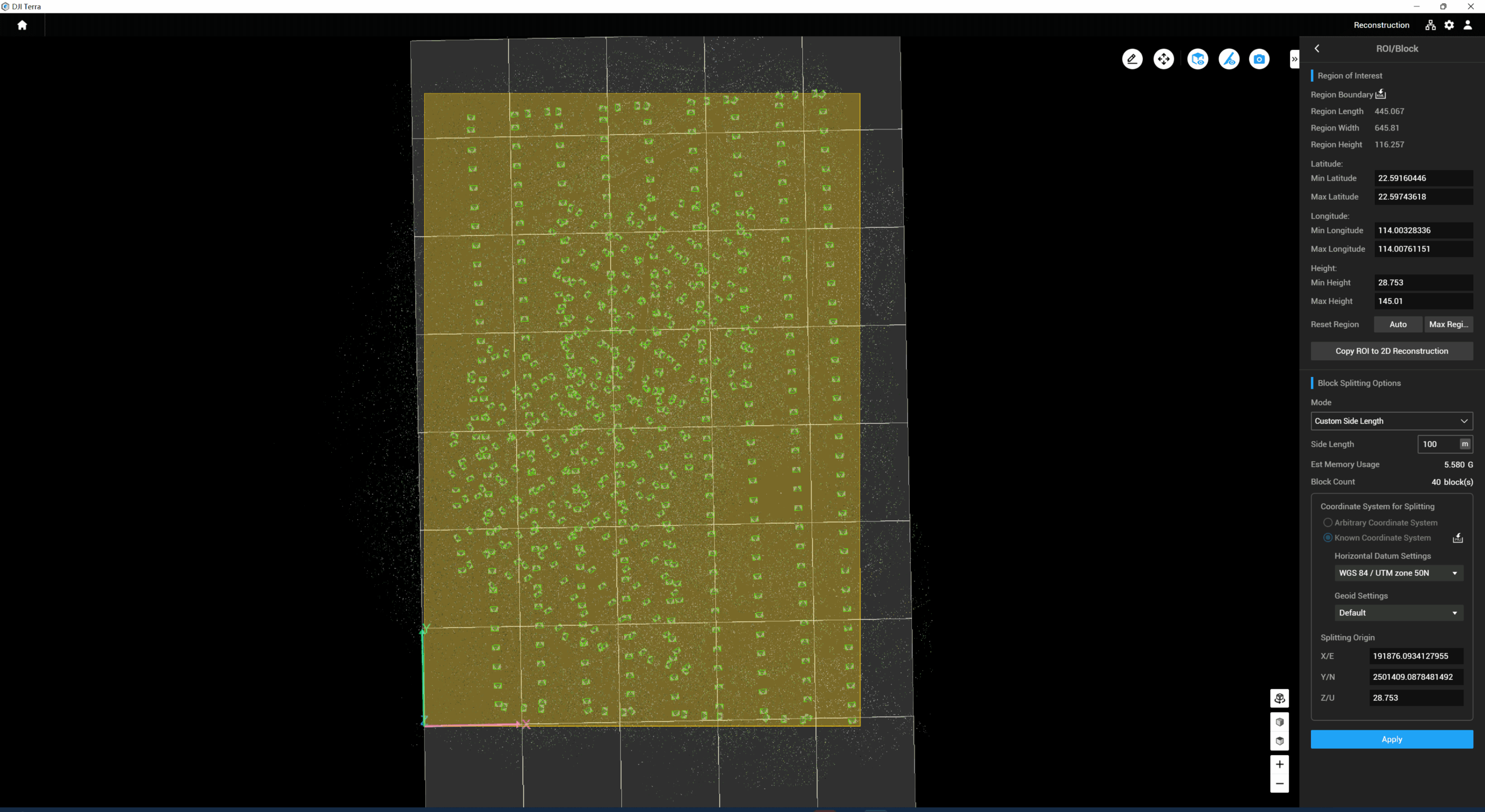
With the Region of Interest (ROI) and block, image reconstruction can be performed to specific target region. In turn, this saves processing time and improves efficiency, while generating a clearer model or point cloud, and completing the large-scale block reconstruction and montage.
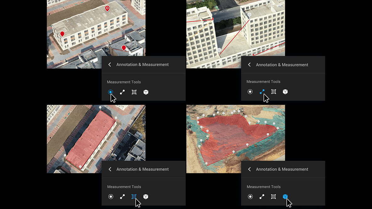
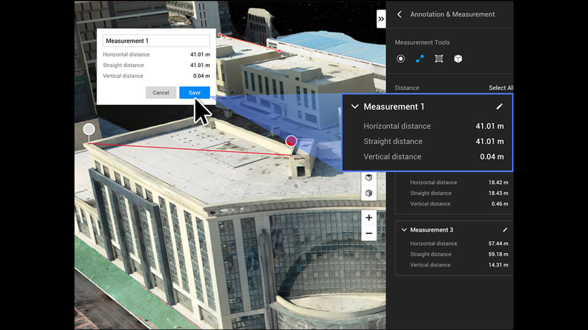
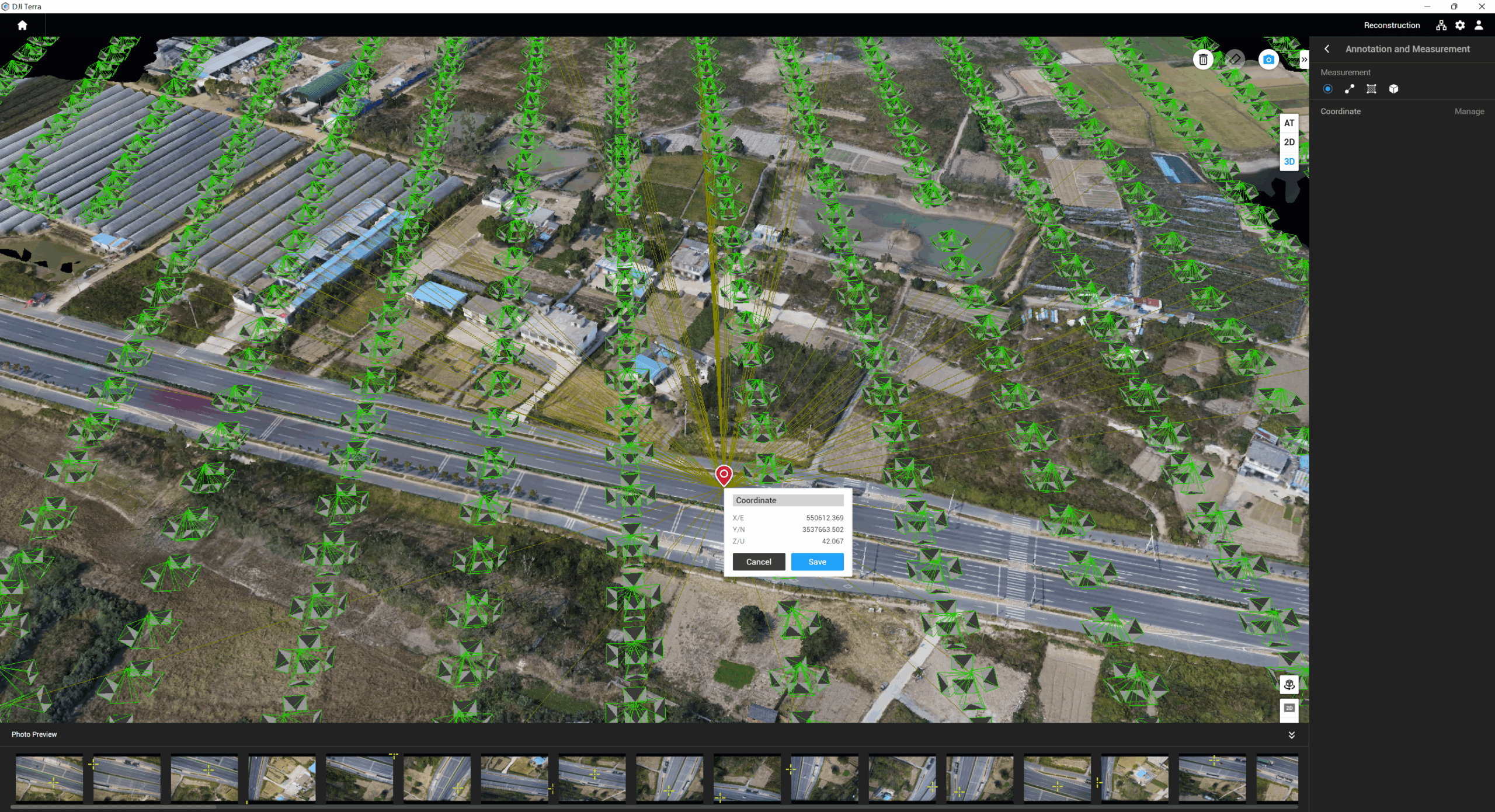
Acquire key dimensions across an array of terrains with easy-to-use analysis tools that enable you to obtain a variety of measurement data based on linear, area and volumetric measurements.
Edit labels of measurements on existing models, which can be used for reporting and improving communication throughout ongoing projects.
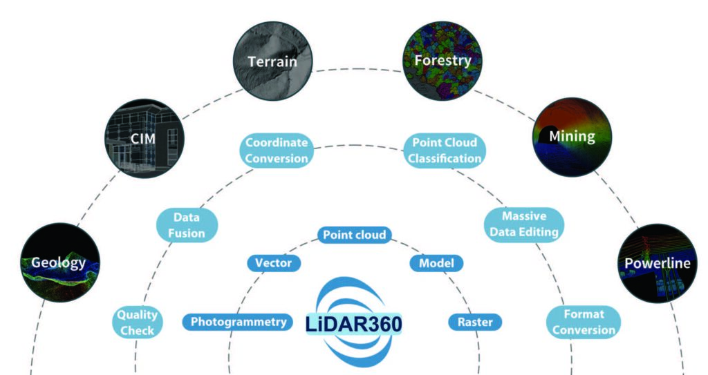
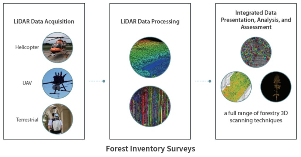
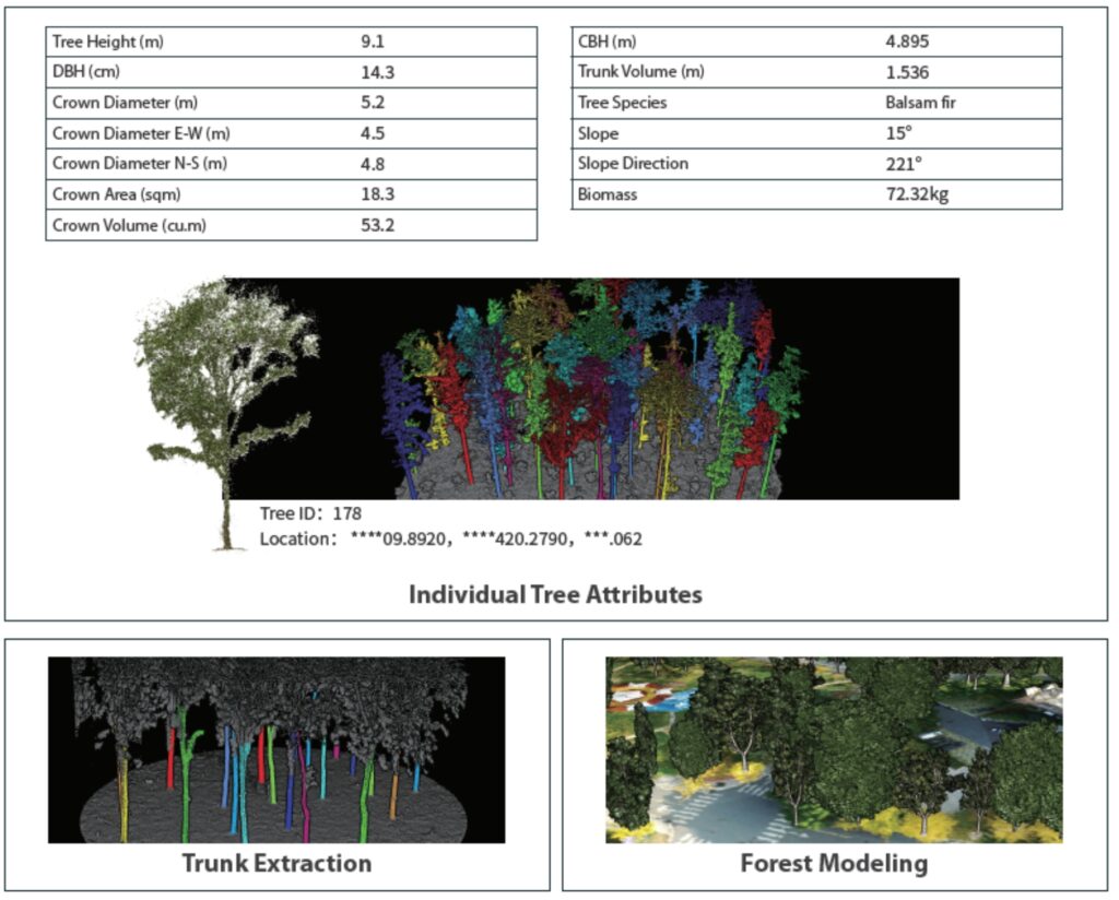
LiDAR has unique advantages in forestry surveys. LiDAR360 can automatically extract forest parameters such as canopy density and clearance rate, as well as single tree attributes such as tree height, diameter at breast height, crown width, and trunk volume based on LiDAR point cloud data and conduct intelligent statistical analysis to help sample plot surveys, carbon sink detection, and other applications, providing unparalleled support for forest resource surveys.
LiDAR technology can penetrate parts of the ground and quickly acquire a wide range of high-precision terrain point cloud data in a short period of time, enabling fast, low-cost, and
large-area ground measurements.
LiDAR360 can automate the processing of terrain observation data, accurately acquire terrain and landscape feature information, produce various data results and high-precision models required for industrial applications, and provide a wealth of analysis tools to help increase the quality and efficiency of terrain mapping.
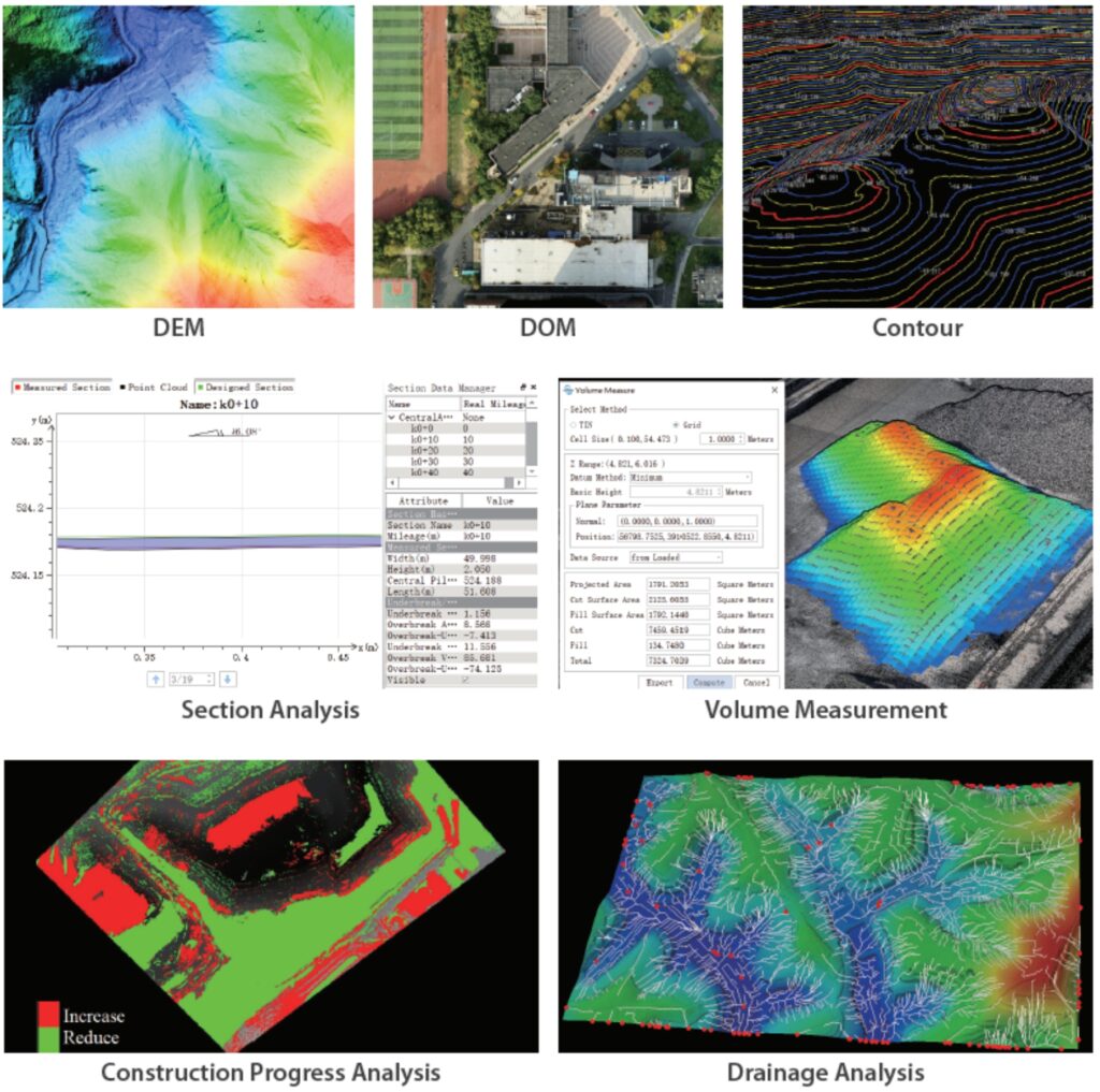
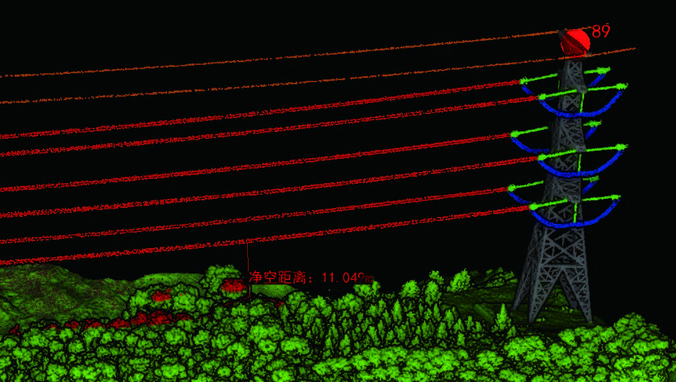
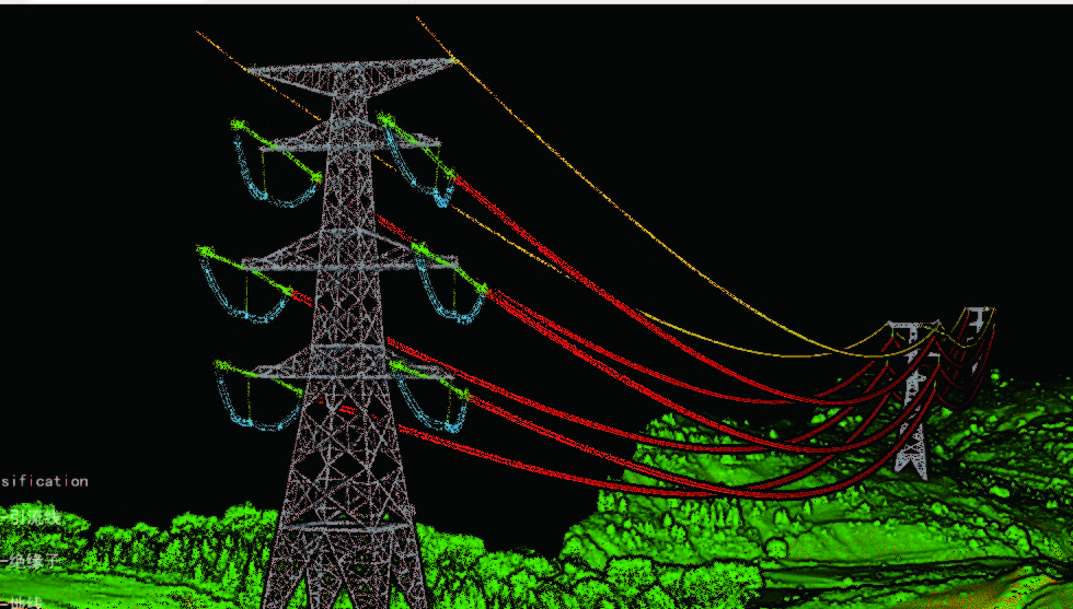
LiDAR360 enables the automatic classification of power line and pylon point clouds, real-time analysis of power line conditions, and the establishment of a sample library of machine learning classification algorithms to accurately and effectively reproduce the topography, geomorphology, and geological conditions within the transmission line corridor. The LiDAR360 software enables unified data management and analysis of transmission line cross-overs, tree barriers, and geology within the transmission line corridor in accordance with relevant transmission line operating regulations, completing a 3D visualization of the transmission line corridor, and enabling rapid and efficient power line hazard detection and identification in the power grid system.
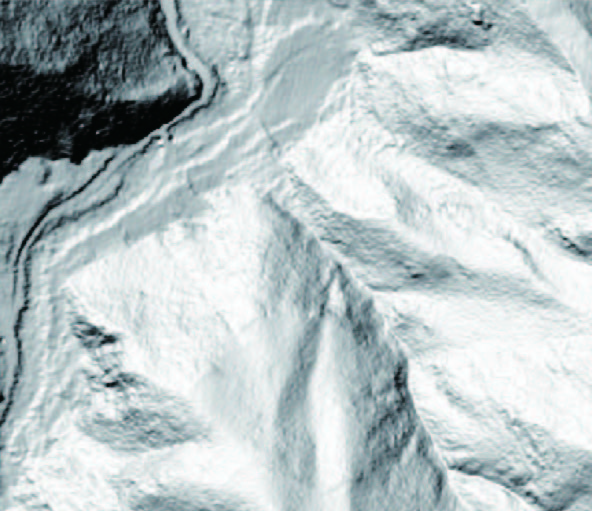
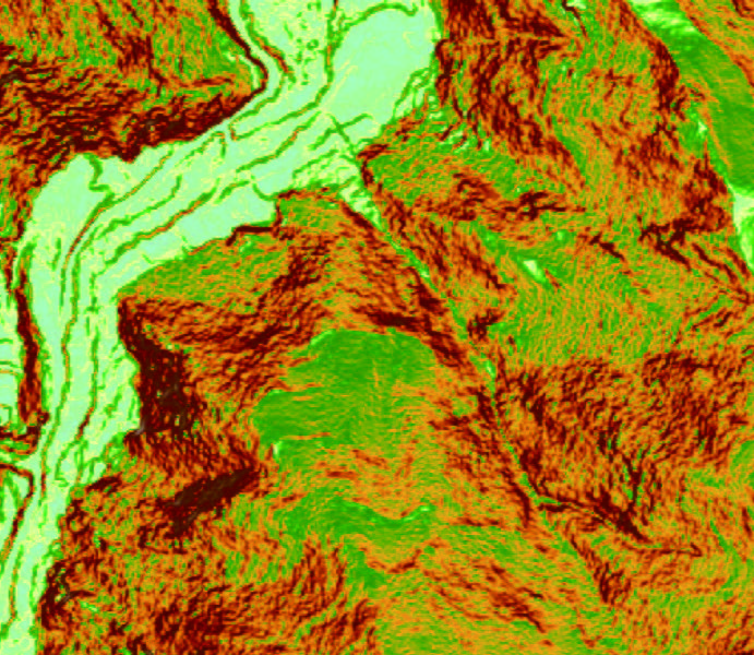
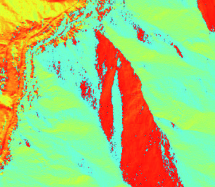
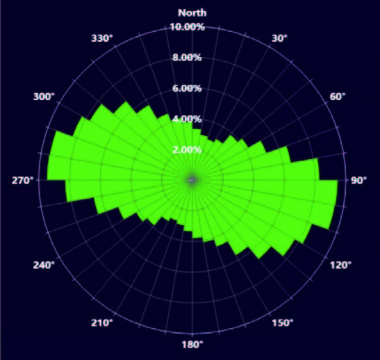
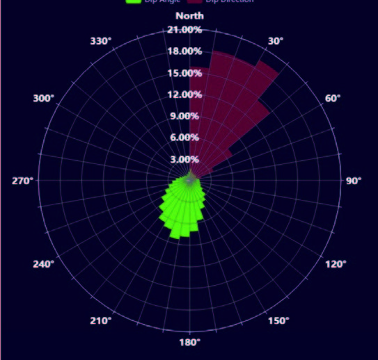
LiDAR is one of the few remote sensing technologies that can penetrate vegetation to obtain ground DEMs. LiDAR360 can accurately extract ground points from LiDAR point clouds and obtain parameters such as slope and slope direction for section and terrain change analysis, providing support for environmental surveys, disaster monitoring, and mining surveys.
Based on the 3D point cloud data obtained from multiple platforms such as airborne and backpack systems, LiDAR360 mining module enables slope line extraction, stockpile volume measurement, and multi-period change analysis of open pit mines, as well as roadway modeling, section analysis, and point cloud classification to meet the needs of applications such as transport step laying, stockpile change monitoring, and construction acceptance, efficiently supporting mining production.
LiDAR360 identifies ground, vegetation, buildings, and other feature targets from massive point cloud data, and employs intelligent algorithms for terrain and feature scene separation, vegetation, and building target monolithic segmentation and modeling to achieve city-level geographic scene and physical replica restoration, helping real-world 3D construction.

Cloud Server Online Processing, Balancing Performance and Efficiency


Surveyors can import the data outcomes from INNO8 into SOUTH UAV and other third- party modeling software for 3D modeling.
SGO (PC version) and SurvStar (Android App) will also support 3D modeling functions in the future. Users can choose the software that best suits the current scenario and task requirements to achieve the highest work efficiency.
Experience INNO8 AR stakeout by following the real-time, real-scene guidance on the data controller display without continuously watching on the compass or leveling the pole.
In addition to points, INNO8 can handle staking out lines and curves with AR, which broaden its applications and is suitable for more complex work demands. With AR stakeout, you can now achieve quick and precise stakeouts with ease.
| Parameter | Value |
|---|---|
| Dimensions (unfolded, without propellers) | 810×670×430 mm (L×W×H) |
| Dimensions (folded, with propellers) | 430×420×430 mm (L×W×H) |
| Diagonal Wheelbase | 895 mm |
| Weight (with single downward gimbal) | Without batteries: ~3.77 kg With two TB65 batteries: ~6.47 kg |
| Single Gimbal Damper’s Max Payload | 960 g |
| Max Takeoff Weight | 9.2 kg |
| Operating Frequency | 2.4000-2.4835 GHz 5.150-5.250 GHz (CE: 5.170-5.250 GHz) 5.725-5.850 GHz<sup>1</sup> |
| Transmitter Power (EIRP) | 2.4000-2.4835 GHz: < 33 dBm (FCC) < 20 dBm (CE/SRRC/MIC)5.150-5.250 GHz (CE: 5.170-5.250 GHz): < 23 dBm (CE)5.725-5.850 GHz: < 33 dBm (FCC/SRRC) < 14 dBm (CE) |
| Hovering Accuracy (with moderate or no wind) | Vertical: ±0.1 m (vision positioning) ±0.5 m (GNSS positioning) ±0.1 m (RTK positioning)Horizontal: ±0.3 m (vision positioning) ±1.5 m (GNSS positioning) ±0.1 m (RTK positioning) |
| RTK Positioning Accuracy (RTK FIX) | 1 cm + 1 ppm (horizontal) 1.5 cm + 1 ppm (vertical) |
| Max Angular Velocity | Pitch: 300°/s Yaw: 100°/s |
| Max Pitch Angle | 30°<sup>2</sup> |
| Max Ascent Speed | 6 m/s |
| Max Descent Speed (vertical) | 5 m/s |
| Max Tilted Descent Speed | 7 m/s |
| Max Horizontal Speed | 23 m/s |
| Max Flight Altitude | 5000 m<sup>3</sup> 7000 m<sup>4</sup> |
| Max Wind Speed Resistance | 12 m/s |
| Max Flight Time | 55 minutes<sup>5</sup> |
| Supported DJI Gimbals | Zenmuse H30, H30T, H20, H20T, H20N, L2, L1, P1, S1, V1 |
| Third-Party Payload | Supports only certified payloads (DJI Payload SDK) |
| Supported Gimbal Configurations | Single downward/upward gimbal Dual downward gimbals Single downward + upward gimbal Dual downward + single upward gimbal |
| Ingress Protection Rating | IP55<sup>6</sup> |
| Global Navigation Satellite System | GPS + GLONASS + BeiDou + Galileo |
| Operating Temperature | -20° to 50° C (-4° to 122° F) |
| Class | C3 (EU) |
| Parameter | Value |
|---|---|
| Screen | 7.02″ LCD, 1920×1200, 1200 nits |
| Weight | ~1.25 kg (without WB37 battery) ~1.42 kg (with WB37 battery) |
| GNSS | GPS + Galileo + BeiDou |
| Built-in Battery | Li-ion (6500 [email protected] V) Charging: 65 W USB-C (2 hrs) Chemistry: LiNiCoAlO2 |
| External Battery (WB37) | 4920 mAh, 7.6 V, Li-ion (37.39 Wh, LiCoO2) |
| Ingress Protection Rating | IP54 |
| Operating Time | Built-in: ~3.3 hrs Built-in + WB37: ~6 hrs |
| Operating Temperature | -20° to 50° C (-4° to 122° F) |
| Operating Frequency | 2.4000-2.4835 GHz 5.725-5.850 GHz |
| Transmitter Power (EIRP) | 2.4000-2.4835 GHz: < 33 dBm (FCC) < 20 dBm (CE/SRRC/MIC)5.725-5.850 GHz: < 33 dBm (FCC) < 14 dBm (CE) < 23 dBm (SRRC) |
| Wi-Fi Protocol | Wi-Fi 6 |
| Wi-Fi Frequency | 2.4000-2.4835 GHz 5.150-5.250 GHz 5.725-5.850 GHz |
| Bluetooth Protocol | Bluetooth 5.1 |
| Bluetooth Frequency | 2.4000-2.4835 GHz |
| Parameter | Value |
|---|---|
| System | DJI O3 Enterprise Transmission |
| Antenna | 4 antennas (2T4R) |
| Max Transmission Distance (unobstructed) | 20 km (FCC) 8 km (CE/SRRC/MIC) |
| Max Transmission Distance (with interference) | Low interference + buildings: 0-0.5 km Low interference + trees: 0.5-3 km Strong interference (urban): 1.5-3 km Medium interference (suburban): 3-9 km Low interference (seaside): 9-20 km<sup>7</sup> |
| Parameter | Value |
|---|---|
| Obstacle Sensing Range | Forward/Backward/Left/Right: 0.7-40 m Upward/Downward: 0.6-30 m |
| FOV | Forward/Backward/Downward: 65° (H), 50° (V) Left/Right/Upward: 75° (H), 60° (V) |
| Operating Environment | Surfaces with patterns, lux > 15 |
| Parameter | Value |
|---|---|
| Obstacle Sensing Range | 0.1-8 m |
| FOV | 30° (±15°) |
| Operating Environment | Reflective obstacles (>10% reflectivity) |
| Parameter | Value |
|---|---|
| Effective Illumination Distance | 5 m |
| Illumination Type | 60 Hz, solid glow |
| Parameter | Value |
|---|---|
| Resolution | 1080p |
| FOV | 142° |
| Frame Rate | 30 fps |
| Parameter | Value |
|---|---|
| Capacity | 5880 mAh |
| Voltage | 44.76 V |
| Type | Li-ion (263.2 Wh) |
| Weight | ~1.35 kg |
| Operating Temperature | -20° to 50° C (-4° to 122° F) |
| Ideal Storage Temperature | 22° to 30° C (71.6° to 86° F) |
| Charging Temperature | -20° to 40° C (-4° to 104° F)<sup>8</sup> |
| Charging Time | 220V: ~60 mins (full), ~30 mins (20-90%) 110V: ~70 mins (full), ~40 mins (20-90%) |
| Parameter | Value |
|---|---|
| Dimensions | 580×358×254 mm (L×W×H) |
| Net Weight | ~8.98 kg |
| Compatible Items | 8× TB65, 4× WB37 |
| Input Voltage | 100-120 VAC / 220-240 VAC (50-60 Hz) |
| Max Input Power | 1070 W |
| Output Power | 100-120V: 750 W 220-240V: 992 W |
| Operating Temperature | -20° to 40° C (-4° to 104° F) |
Frequency restrictions may apply in some regions.
25° in N mode with forward vision enabled.
With 2110s propellers (takeoff weight ≤ 7.4 kg).
With 2112 High-Altitude Propellers (takeoff weight ≤ 7.2 kg).
Measured at 8 m/s, no payload, windless. Actual time varies.
IP rating may degrade over time.
FCC compliance, 120 m altitude. Actual range varies.
Auto-heating below 5° C; recommended: 15-35° C.
| Camera Type | RGB Mapping Camera
|
| Compatibility | DJI Matrice 300 RTK with DJI RC Plus / Matrice 350 RTK |
| Camera Type | LiDAR
|
| Camera Type | Gimbal
|
| System |
|
| System |
|
| Wireless | Yes |
| Mobile App Compatible | No |
| Power Source |
Proprietary Interface
|
| Power Consumption | 28 W (Typical) 58 W (Maximum) |
| Environmental Protection | No |
| Storage Temperature | -4 to 140°F / -20 to 60°C |
| Color | Black |
| Cable Length | Not Specified by Manufacturer |
| Dimensions | 6.9 x 6.1 x 5″ / 176 x 155 x 128 mm |
| Weight | 2 lb / 905 g |
| Equipment | ground, mobile, airborne laser scanners |
| Format | LiData LAS LAS E57 |
| Modules | Forest, Relief, Power lines |
| Product Name | south INNO8 |
| Channels | 1598 |
| GPS: | L1, L1C, L2C, L2P, L5 |
| GLONASS: | L1C/A,L1P,L2C/A,L2P,L3 |
| BDS: | BDS-2: B1I, B2I, B3I, BDS-3: B1I, B3I, B1C, B2a, B2b* |
| GALILEO: | E1, E5A, E5B, E6C, AltBOC* |
| SBAS(WAAS/MSAS/EGNOS/GAGAN): | (WAAS/MSAS/EGNOS/GAGAN): L1* |
| IRNSS: | L5* |
| QZSS: | L1, L2C, L5* |
| MSS L-Band: | BDS-PPP, Galileo HAS |
| Other Features | Positioning output rate: 1Hz~20Hz |
| Code differential GNSS positioning | H: 0.25m+1 ppm RMS V: 0.50m+1 ppm RMS |
| Static(long observations) | H: 2.5mm+0.1 ppm RMS V: 3mm+0.4 ppm RMS |
| Rapid static | H: 2.5 mm + 0.5 ppm RMS V: 5 mm + 0.5 ppm RMS |
| PPK | H: 3 mm + 1 ppm RMS V: 5 mm + 1 ppm RMS |
| RTK(NTRIP) | H: 8 mm + 0.5 ppm RMS V: 15 mm + 0.5 ppm RMS |
| RTK initialization time | 2 ~ 8s |
| BDSPPP | H:10cm V: 20cm |
| Galileo HAS | H: 20cm V: 40cm |
| Operating system | Linux |
| Dimension | 155mm(Φ) *98.5mm(H) |
| Weight | 1.2kg |
| Material | Magnesium aluminum alloy shell |
| Temperature | Working: -45ºC to +75ºC Storage: -55ºC to +85 ºC |
| AR Stakeout Camera | Pixel:2M |
| Visual Angle:75° | |
| I/O Ports | 5-PIN LEMO (external power port + RS232) Type-C(charge+USB+OTG+Ethernet) UHF antenna interface |
| Cellular Network | 4G LTE, 3G WCDMA, 2G GPRS, GSM |
| Feature/Version | Agriculture | Pro | Electricity | Cluster | Education |
|---|---|---|---|---|---|
| Real-time 2D Mapping | |||||
| Agricultural application | |||||
| 2D Reconstruction (Field) | |||||
| 2D Multispectral Reconstruction | |||||
| 2D Reconstruction (Urban) | |||||
| KML file import | |||||
| Output Coordinate System | |||||
| ROI Reconstruction | |||||
| Image POS import | |||||
| Multi-GPU Reconstruction | |||||
| 3D Reconstruction | |||||
| 3D Mission planning | |||||
| Real-time 3D Mapping | |||||
| GCPs | |||||
| LiDAR Point Cloud Accuracy Optimization | |||||
| LiDAR Point Cloud Smoothing | |||||
| Categories of ground points of LiDAR point cloud | |||||
| Electricity Application | |||||
| Detailed Inspection | |||||
| Cluster Computation | |||||
| Bind Device 16 | 3 devices | 1 device | 1 device | 1 Device 3 nodes | Contact Us |
| Authorization mode13 | Online | Online/Offline | Online | Offline | Online |
| Validity Period | 1 year | 1 Year / Permanent14 (Free update for the first year, paid update from the next year) |
1 year | Permanent14(Free update for the first year, paid update from the next year) | Permanent |
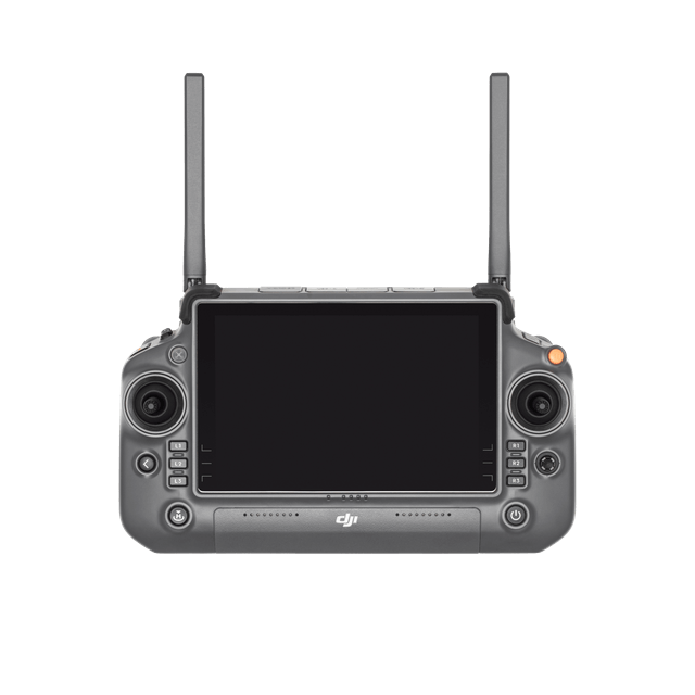


DJI RC Plus has a 7-inch screen with a brightness of up to 1,200 nits as well as multiple buttons, delivering a smooth control experience. It comes with a standard WB37 external battery and supports battery hot swapping. It can operate for up to 6 hours when combining internal and external batteries for use.
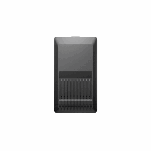
The battery station provides a one-stop solution for battery charging, storage, and transport. The new Storage Mode and Ready-to-Fly Mode improve charging efficiency and extend the battery life. The new design of 360°-movement wheels facilitates more convenient transportation and transitions.
The TB65 Intelligent Flight Battery adopts high-performance and high-energy cells and can be charged up to 400 cycles, [3] reducing the cost for a single flight. Meanwhile, it has enhanced heat dissipation performance and an auto-heating system.
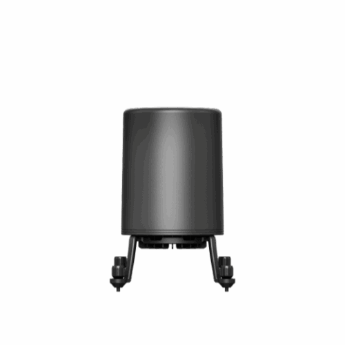
The CSM Radar can be mounted on top of the drone to further ensure flight safety. The effective detection range can reach 30 m. [10] The radar can accurately detect subtle obstacles upward or within the horizontal 360° range to avoid them in time.
This kit enables the aircraft to access 4G networks for Enhanced Transmission when used in conjunction with a remote controller connected to the internet, easily handling signal obstructions for safer flight operations.
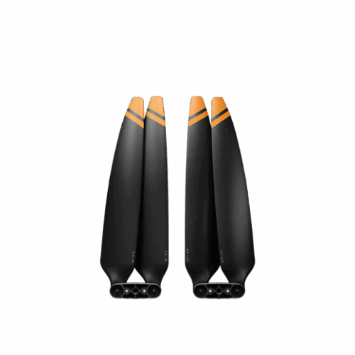
The high-altitude low-noise propellers guarantee flight performance at high altitudes of 3,000-7,000 m, and the noise of the blades is reduced by 2 decibels compared with the standard 2110s propellers.
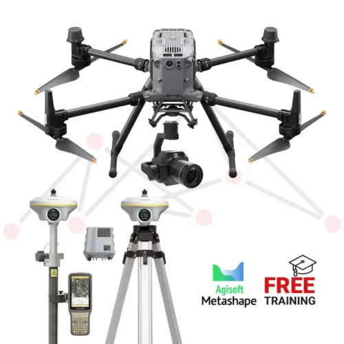
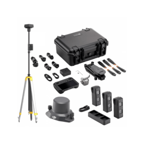
Inquire price for DJI Matrice 350 RTK with DJI L2 Aerial LiDAR and Ground Surveying Bundle using South GNSS