Mining has always depended on accurate information. Every decision—from where to drill to how to restore a site after extraction—relies on understanding what is happening both above and below the ground.
For years, drones were mainly used to replace traditional surveying. Today, their role is much broader. Modern UAV platforms generate high-resolution spatial data that supports exploration, drilling, production planning, safety monitoring, environmental restoration, and virtually every stage in between.
This article explores how drone technology is being integrated throughout the mining lifecycle, highlighting practical applications, real-world results, and the technologies that make these workflows possible.
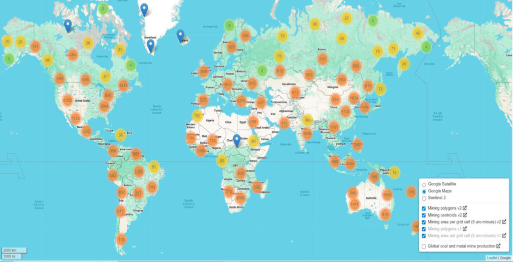
The mining industry continues to expand. Today, there are more than 15,000 active mines worldwide, with open-pit operations accounting for approximately 70–80% of metal mines and more than 90% of coal mines.
At the same time, mining companies face growing pressure from rising labor costs, workforce shortages, stricter environmental regulations, and increasingly complex deposits. As easily accessible resources become scarcer, every operational decision has greater financial consequences.
Across different mine types, the challenges are remarkably similar:
Many of these problems have one thing in common: they require reliable, frequently updated spatial information.
Finding economically viable ore bodies has always been one of the most difficult stages of mining.
Traditional exploration relies on field surveys, GPS measurements, total stations, geological mapping, and extensive manual sampling. These methods are often slow, expensive, and difficult to perform in remote or hazardous terrain. More importantly, surface observations alone rarely provide enough information to identify complex mineral systems.
Instead of replacing existing methods, many mining companies are now combining multiple data sources into a single exploration workflow.
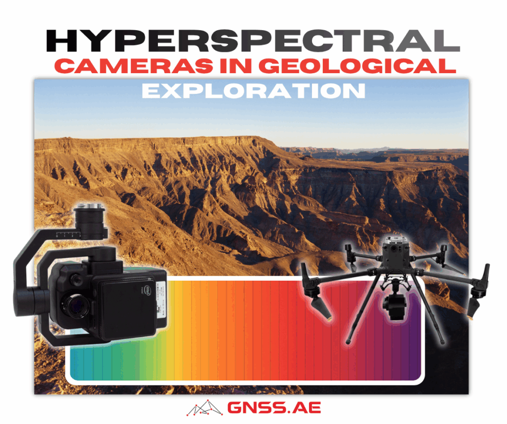
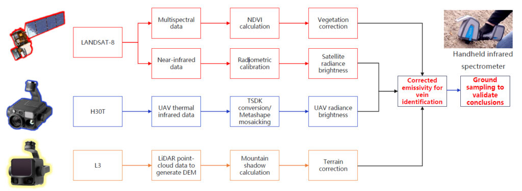
Satellite imagery provides regional coverage, drones deliver higher-resolution terrain and thermal information, while field measurements verify anomalies identified remotely.
A typical workflow includes:
The combination allows geologists to narrow down promising targets before expensive ground investigations begin.
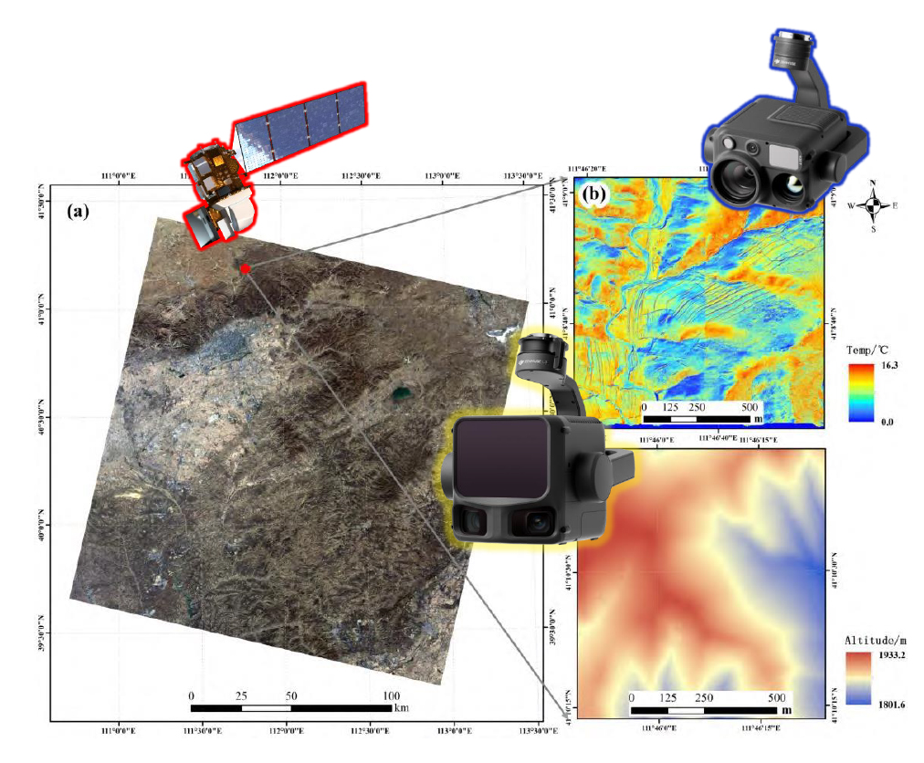
One practical example comes from Hutou Mountain in China. The workflow combined Landsat satellite imagery, thermal data collected with the DJI Matrice 30T, terrain information from the Zenmuse L3 LiDAR, and ground-based spectral measurements.
The integrated approach achieved 93% vein identification accuracy, while the number of newly identified exposed mineral veins approximately doubled compared to traditional exploration methods.
The approach does have limitations. Thermal imaging typically detects only shallow surface features—generally within about five meters of depth. For deeper exploration, airborne magnetic surveys remain necessary.
Fortunately, modern UAV platforms can also carry specialized geophysical sensors. Systems such as optical pumping magnetometers can be integrated with industrial drone platforms, allowing rapid low-altitude aeromagnetic surveys that help identify concealed ore bodies hundreds of meters below the surface.
Once the ore body has been identified, the next challenge is extracting it efficiently.
Poor drilling accuracy or poorly designed blast patterns increase dilution, waste valuable ore, consume excessive explosives, and create oversized rock fragments that reduce downstream productivity.
Drone mapping has introduced a much more data-driven approach.
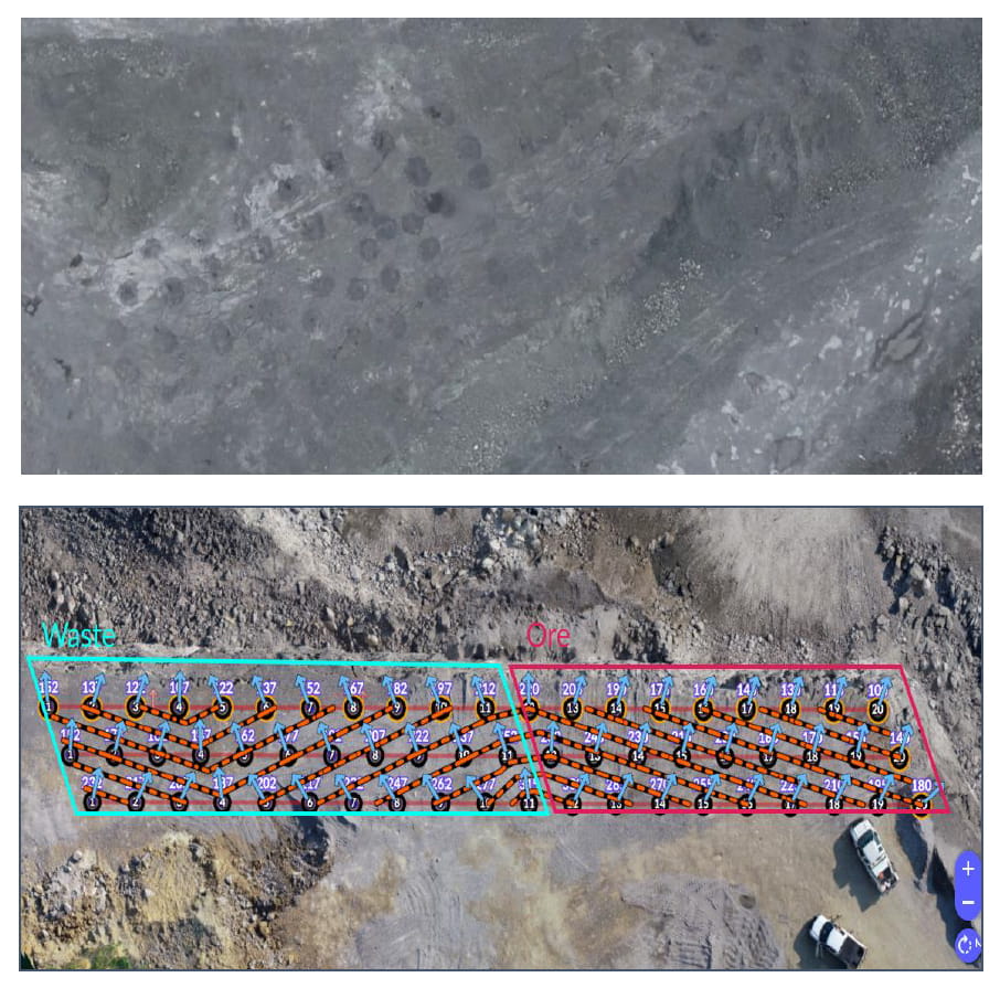
Before blasting, UAVs equipped with RTK positioning capture highly accurate terrain data that is processed into detailed 3D models. These models are imported into mine planning software, where engineers optimize blast design based on actual site conditions rather than assumptions.
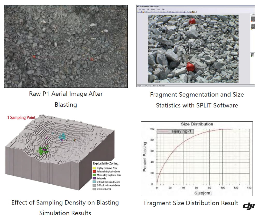
After blasting, another drone survey evaluates fragmentation quality. Image analysis automatically measures rock particle size distribution, allowing engineers to compare actual results with predicted outcomes and continuously improve future blast designs.
One tungsten mining project demonstrated how this feedback loop reduced uncertainty in explosive planning.
By combining UAV mapping, LiDAR point clouds, and blasting simulation software, the prediction error for explosive consumption was reduced to only 0.15 kg per cubic meter, while significantly reducing the need for manual sampling.
Interestingly, engineers also found that three physical validation samples per blast area provided nearly all the accuracy benefits. Collecting additional samples produced only marginal improvements while increasing fieldwork.
Haulage often represents one of the largest operating costs in open-pit mining.
Road conditions directly affect fuel consumption, tire wear, vehicle maintenance, and cycle times. Yet inspections are frequently performed manually and only after visible deterioration appears.
Drone surveys enable a more proactive approach.
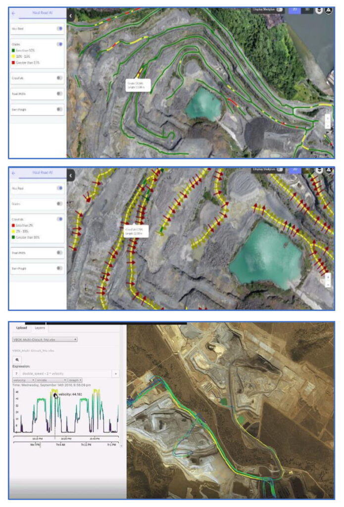
Regular flights capture the entire haul road network, while photogrammetry software generates detailed digital twins. AI-based analysis identifies potholes, rutting, drainage issues, and surface deformation long before they become major maintenance problems.
Because inspections can be repeated regularly, mines can measure how road improvements affect fuel usage and vehicle wear, turning maintenance decisions into measurable cost-saving initiatives rather than reactive repairs.
Mining operations change every day. Excavation progresses, stockpiles grow, pit geometry evolves, and production managers need current information—not data collected several weeks earlier.
Drone surveys allow mines to produce accurate volumetric calculations and production reports within hours.
One example highlighted during the webinar comes from the KCGM gold mine in Australia. The operation covers approximately 5.7 km², with an open pit reaching depths of around 580 meters. Using a DJI Matrice 400, Zenmuse L3 LiDAR, and RTK positioning, the entire pit can be scanned in about 20 minutes.
Processing the point cloud requires roughly one hour, while complete production analysis—including pit advancement, excavation progress, and volume calculations—can be delivered in approximately two hours
This enables daily production reporting rather than relying on periodic surveys.
Safety remains one of mining’s highest priorities.
Highwalls, unstable slopes, underground voids, and post-blast environments all present risks that are difficult—and often dangerous—to inspect manually.
Instead of sending survey teams into hazardous areas, drones can collect repeatable datasets from a safe distance.
Repeated photogrammetry or LiDAR surveys allow engineers to compare successive terrain models and detect subtle deformation before failures occur.
For example, monitoring systems developed for large open-pit mines combine UAV imagery with geotechnical analysis software to:
In one Queensland mining project, high-resolution imagery with a ground sampling distance (GSD) of 3–4 cm allowed engineers to identify small cracks across highwalls. Processed terrain models were then analyzed in specialized geotechnical software to assess slope stability and prioritize preventive action.
Instead of reacting after failures occur, mines gain the ability to identify potential hazards much earlier.
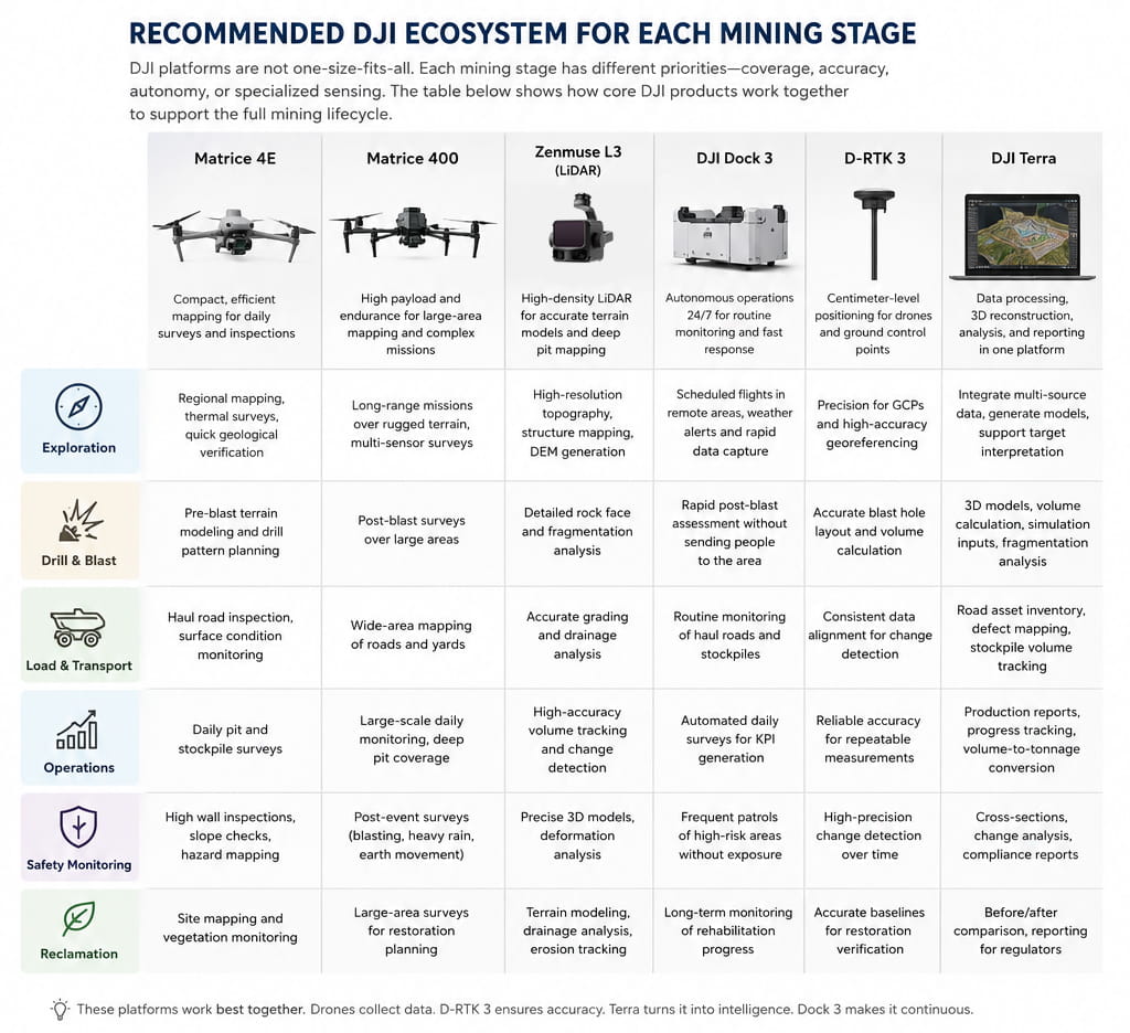
Perhaps the biggest shift in modern mining is not the drone itself—it is the way drone data is used.
A single survey may support exploration, engineering design, production planning, safety analysis, environmental monitoring, and reporting simultaneously.
Instead of collecting new data for every department, many mining companies are building integrated digital workflows around continuously updated spatial models.
The result is a digital representation of the mine that evolves alongside operations, allowing teams to make faster, better-informed decisions throughout the entire lifecycle.
As drone platforms continue to support more advanced sensors—including LiDAR, thermal cameras, multispectral payloads, and geophysical instruments—their role in mining is likely to expand even further. Rather than serving as standalone surveying tools, drones are increasingly becoming the foundation of data-driven mining operations.