Drone mapping workflows—whether they rely on photogrammetry, LiDAR, or a mix of both—are usually built on a few key assumptions: the environment is visually structured, surfaces remain relatively stable during data capture, and atmospheric conditions do not significantly distort sensor measurements.
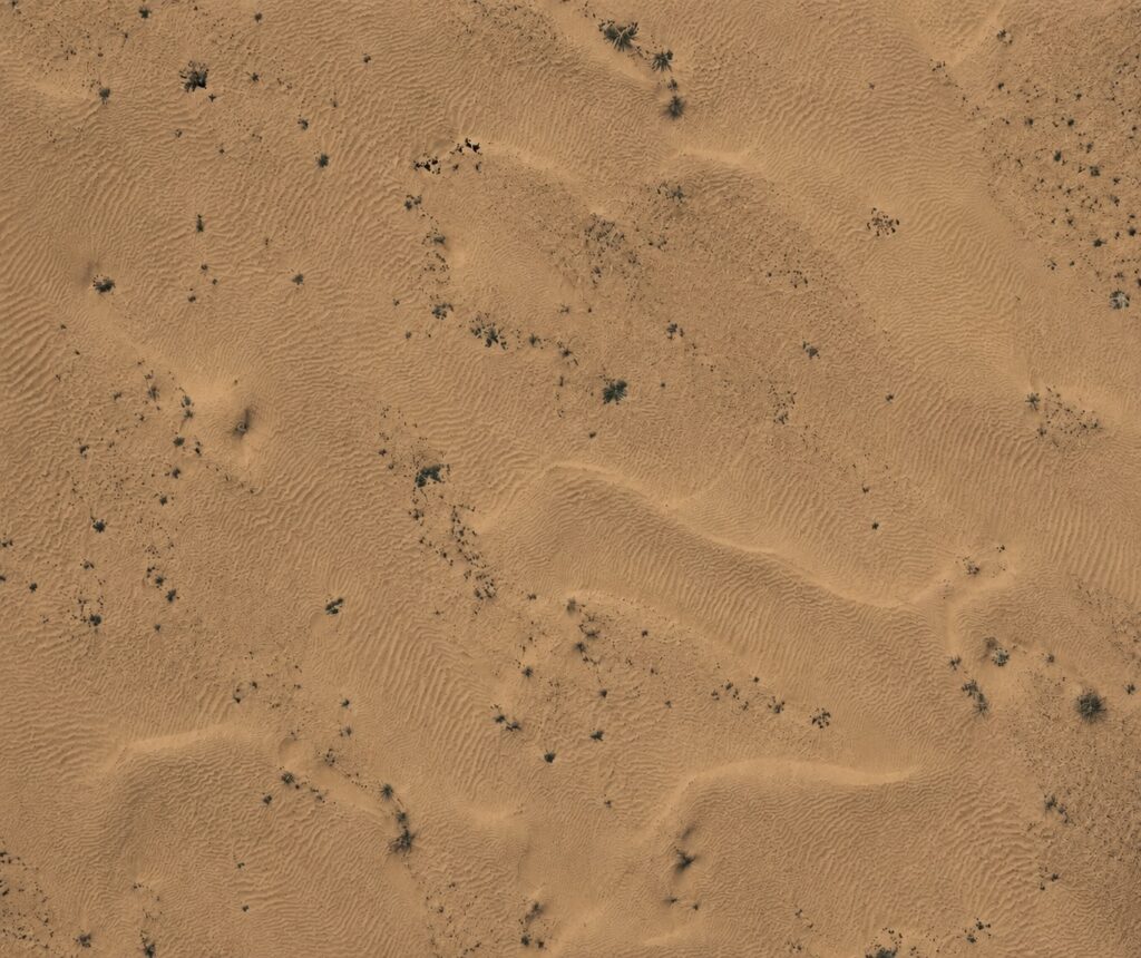
All three are broken in deserts. Instead of providing a stable geometric and visual framework, a desert creates an environment defined by repetition, instability, and radiometric extremes. Surfaces are often featureless, highly reflective under intense solar exposure, and constantly reshaped by wind. At the same time, high temperatures and airborne particles affect the propagation of both light and laser signals.
The result is a systematic breakdown of the assumptions that mapping algorithms rely on—affecting photogrammetry, LiDAR, and even GNSS-supported workflows in different ways.
However, many of the limitations that once made desert mapping unreliable are now being addressed through new generations of integrated drone systems. In this article, we will explore how modern DJI technologies are changing the way these environments are captured, processed, and analyzed—transforming challenges that were once considered critical limitations into manageable operational conditions.
Photogrammetry relies on stable visual features to generate reliable tie points and reconstruct geometry through Structure-from-Motion (SfM) algorithms.
In desert environments, reconstruction quality can be affected by several terrain characteristics, including:
As a result, feature matching may become less consistent, potentially reducing alignment stability and reconstruction accuracy.
This can lead to:
Modern DJI surveying platforms, combined with RTK positioning, optimized flight planning, and advanced photogrammetry software, significantly improve data reliability and reconstruction performance even in challenging desert conditions.
Desert sand reflects more light than many natural surfaces commonly encountered in mapping workflows. Under strong sunlight, this can reduce local contrast and make subtle surface details less visible in some areas of an image.
However, modern aerial imaging cameras—especially DJI cameras used in professional mapping systems—are increasingly designed to operate reliably in these environments. Features such as:
allow modern photogrammetry workflows to compensate for extreme illumination conditions far more effectively than earlier-generation systems.
In most practical surveying scenarios, proper flight planning, calibrated exposure settings, and the use of modern DJI imaging systems are sufficient to maintain reliable image quality and stable reconstruction performance, even under intense desert sunlight.

GNSS technologies such as RTK and PPK can provide highly accurate positioning in open desert environments due to strong satellite visibility and minimal signal obstruction.
However, precise georeferencing alone does not fully guarantee reconstruction quality in photogrammetry or LiDAR workflows. The final model accuracy still depends on factors such as:
As a result, a dataset may be accurately georeferenced while still containing local geometric distortions or reconstruction artifacts if the source imagery lacks sufficient detail or consistency.
Ground control points, checkpoints, and proper survey validation remain important for confirming overall model reliability.
A more detailed breakdown of how hybrid positioning strategies improve robustness—especially in challenging survey conditions—can be found in one of our previous articles on hybrid workflows: Hybrid RTK + PPK Workflows: Improving Reliability in Drone Mapping
High surface temperatures create strong vertical temperature gradients in the air. These gradients can affect the propagation of electromagnetic signals, including GNSS.
While the impact on positioning is usually subtle, it can:
These atmospheric conditions can also influence optical and LiDAR-based sensing systems, introducing additional uncertainty into data acquisition and increasing inconsistencies between different sensor outputs.
Modern DJI surveying platforms partially mitigate these effects through tightly integrated GNSS, IMU, and sensor synchronization systems, helping maintain stable positioning and more consistent data alignment under challenging environmental conditions.

Desert terrain often consists of relatively smooth and geometrically uniform surfaces compared to urban, rocky, or densely vegetated environments.
As a result, LiDAR datasets captured in sandy areas may naturally contain fewer distinct geometric features and sharper surface transitions.
This does not necessarily represent a limitation of LiDAR itself, but rather reflects the physical characteristics of the terrain being surveyed.
Higher point density can improve sampling resolution and surface precision, while the resulting model will still accurately represent the naturally smooth geometry of the environment.
For modern high-density LiDAR systems such as the DJI Zenmuse L3, this is generally not considered a significant limitation. Advanced scanning performance, high point density, and precise IMU/GNSS integration allow the system to capture highly accurate terrain models even in geometrically uniform desert environments.

Desert environments do not affect all systems equally. In practice, performance depends on how specific platforms and payloads respond to three dominant stress factors:
The difference between systems is not whether they “work” or not—but how quickly their limitations become dominant.
High ambient temperatures directly affect UAV platforms, payloads, and onboard electronics. In desert environments, it is common to operate near the upper boundary of specified temperature ranges.
System Type | Example Systems | Typical Operating Range | Behavior Near Limits |
UAV platform | ~ -20°C to +50°C | reduced flight time, battery efficiency drops, thermal warnings | |
Dock-based system | up to ~50°C (with active cooling) | mission scheduling becomes temperature-dependent | |
LiDAR payload | ~ -20°C to +50°C | IMU drift increases, signal stability may degrade | |
RGB mapping camera | DJI Zenmuse P1 / SHARE mapping cameras | typically up to ~45–50°C | reduced contrast, potential sensor overheating, exposure instability |
Oblique cameras | BLV mapping cameras | typically up to ~45–50°C | radiometric inconsistency, increased glare sensitivity |
Multispectral | Airinov multispectral sensors | typically up to ~45–50°C | calibration drift, reduced radiometric stability |
At these temperatures, systems do not stop working—but performance becomes less predictable. Flight time, sensor stability, and data consistency all begin to degrade simultaneously.
Even with high protection ratings, fine airborne particles remain a persistent issue. The impact is gradual rather than immediate, which makes it harder to detect during acquisition.
Modern enterprise UAV systems are specifically designed to operate in harsh environments, including dust exposure. Platforms such as the DJI Matrice 400 and DJI Dock 3 incorporate sealed airframe designs and protected internal components to reduce the impact of particle ingress.
System | Protection Approach | Practical Behavior in Desert |
DJI Matrice 400 | Sealed airframe design | resists coarse dust, but fine particles accumulate over time |
DJI Dock 3 | Enclosed docking system | protects system at rest, not during active flight |
LiDAR payloads | Partial sealing + optical window | dust contamination reduces signal clarity |
Cameras (RGB / multispectral) | exposed optics | lens contamination directly reduces image quality |
These systems are typically rated according to Ingress Protection (IP) standards, which define resistance to dust and moisture. While high IP ratings significantly improve durability, they do not fully eliminate the effects of fine particles—especially on exposed elements such as:
A detailed explanation of how IP ratings apply to UAV systems—and what they actually protect—was covered in one of our previous articles IP Rating in Industrial Drones: What IP55 and IP67 Really Mean in the Field
Across all categories, a consistent pattern emerges:
No system operates independently of environmental constraints. Each one shifts the limitation to a different part of the workflow.
Desert environments do not eliminate the possibility of drone mapping — they simply redefine the operational conditions in which mapping workflows must perform.
The limitations discussed throughout this article are not failures of the technology itself, but predictable characteristics of working in low-structure, high-energy, and dynamically changing environments.
In practice, successful desert mapping depends on several key factors:
At the same time, many of the challenges traditionally associated with desert surveying are now significantly reduced — or in some cases practically eliminated — through the use of modern DJI ecosystems.
Advanced DJI platforms combine:
Systems such as the DJI Matrice series and Zenmuse payloads are specifically designed to maintain reliable data acquisition even in demanding desert conditions involving heat, dust, uniform terrain, and large operational areas.
As a result, modern desert mapping is no longer limited by many of the issues that historically affected aerial surveying workflows. The focus today is not whether accurate desert mapping is possible, but how efficiently the workflow is designed and how effectively the available technology is utilized.
The result is controlled, reliable, and engineering-grade data suitable for analysis, measurement, inspection, and decision-making across a wide range of industries.