Drone mapping workflows used to be built around relatively predictable environments: open terrain, stable GNSS conditions, and surfaces with sufficient visual texture for reconstruction. Under these conditions, both LiDAR and photogrammetry can deliver consistent, high-accuracy results.
A dense urban environment such as Dubai, or AbuDhabi, provides a very different operating environment. Glass facades, reflective surfaces, vertical geometry, and confined airspace mean that classic assumptions are no longer valid.
In these environments, the limiting factor is neither sensor resolution nor nominal accuracy. It’s the stability of data collection in adverse conditions.
In urban canyon conditions, GNSS errors are no longer bounded within centimeter-level tolerances.
Even RTK systems, which are designed to deliver centimeter-level precision, show a clear degradation pattern in urban conditions. In open environments, typical accuracy remains around ~2–3 cm. However, in dense urban areas, average errors increase to ~5 cm, while intermittent deviations exceeding 10 cm become common. In more complex scenarios, positioning accuracy can degrade to meter-level and, in extreme cases, tens of meters in dense city corridors.
The core issue is not that part of the dataset is inaccurate, but that the error profile is unstable and often not immediately detectable. False fixed solutions (“false fix” events) can occur, where the system reports a stable RTK lock while the actual position is systematically offset. This makes the error particularly dangerous, as it appears valid at system level.
In urban environments, three major limitations of GNSS were the main triggers for technological change:
1. Multipath as an unavoidable error source:
Multipath continues to be one of the most stubborn GNSS error mechanisms. In crowded cityscapes, signals bounce off buildings and interfere with the direct paths from satellites, and unfortunately, no post-processing algorithm can completely get rid of this effect.
2. NLOS (Non-Line-of-Sight) signal propagation:
In the narrow spaces between tall buildings, receivers often depend on reflected signals instead of having a clear line of sight to satellites. This can lead to a systematic bias, causing a consistent positional offset rather than just random noise.
3. Satellite geometry degradation and signal loss:
In particularly challenging urban settings, the number of satellites that can be seen may fall below what’s needed for stable positioning, or the arrangement of those satellites might be too weak to provide a reliable solution.
These limitations directly changed the assumptions of traditional drone mapping workflows:
For instance, RTK could no longer be taken for granted as a reliable option in urban settings. PPK, while improving post-processing accuracy, could not fully compensate for corrupted or biased measurements. More details about the hybrid RTK + PPK workflows can be found in one of our previous articles Hybrid RTK + PPK Workflows: Improving Reliability in Drone Mapping.
Photogrammetry workflows suffered from poor geometry and inconsistent tie point generations. This combination of failures led to a system-level constraint: no single positioning or reconstruction method remained stable across all urban conditions.
As a result, the industry shifted toward:
In practice, these failure modes had serious operational consequences:
The key takeaway was that GNSS in urban settings is fundamentally unpredictable. Errors aren’t just random; they’re systematic, depend on the environment, and often go unnoticed at the system level. This realization prompted a significant architectural shift in drone mapping systems: relying on a single positioning source just doesn’t cut it anymore.

To address these challenges, modern systems are moving away from GNSS-centric positioning toward multi-sensor fusion approaches.
Instead of relying primarily on satellite positioning, fusion-based systems combine:
This allows the system to:
The DJI Matrice 400 is an example of how technology is evolving towards a more integrated approach.
Instead of merely trying to improve sensor quality, the platform introduces capabilities designed to make mapping in challenging dense urban or industrial settings feasible.
Fusion positioning
The full 360 omnidirectional sensing performance by rotating LiDAR, high-precision mmWave radar and full-color low-light fisheye vision sensor equips the Matrice 400 with powerful positioning ability. It is able to fly stably toward glass-facade building or wind turbine blade, return safe from building edges, mountain bases or bridge side even the return point is not update.
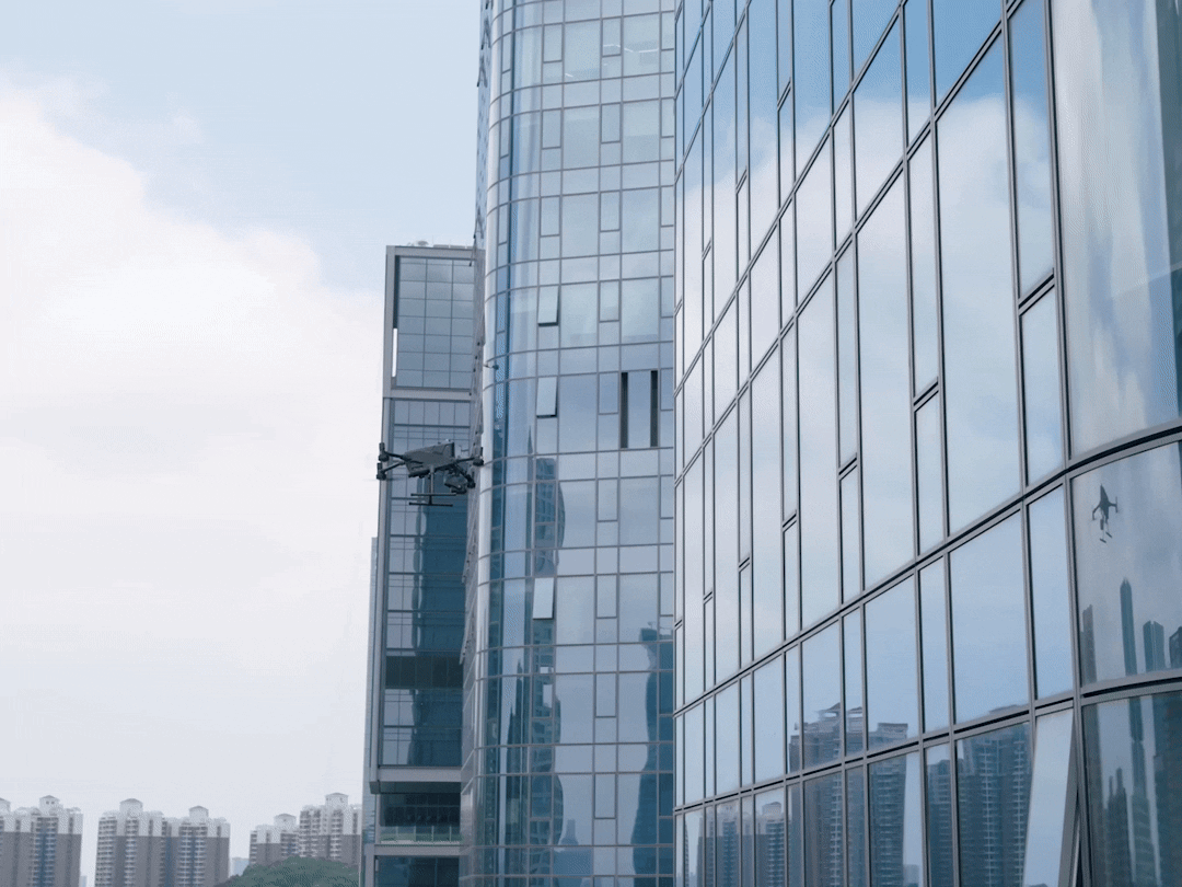

Advanced obstacle sensing enables safer operation in confined and complex spaces, where proximity to structures is unavoidable. This is critical for facade inspections and operations in dense infrastructure environments.
Improved flight stability contributes to more consistent data acquisition under turbulent conditions, helping maintain overlap and reducing motion-related artifacts.


Multi-sensor compatibility allows operators to adapt workflows depending on the scene, combining LiDAR and imaging where necessary to compensate for limitations of individual methods.
Inertial measurement system (IMU)
Onboard inertial measurement system (IMU) operates as a high-frequency motion reference layer, continuously estimating short-term changes in position, velocity, and orientation. While GNSS provides absolute positioning, the IMU maintains trajectory continuity during short-term signal degradation.
It means that even when GNSS becomes unstable due to multipath or obstruction, the system can preserve a consistent flight path over short intervals.

Robust Communication in High-Interference Environments
The DJI Matrice 400 uses the DJI O4 Enterprise Enhanced transmission system, which is designed to maintain a reliable link in environments with high electromagnetic interference and signal reflection.
Unlike single-frequency communication systems, this architecture operates across multiple frequency bands (sub-1 GHz, 2.4 GHz, and 5.8 GHz) and dynamically adapts transmission parameters based on environmental conditions.
Key characteristics include:
In dense urban environments, where signal reflection and obstruction affect not only GNSS but also control links, this multi-layer communication approach reduces the risk of signal loss in urban canyons, unstable video transmission during inspection, and delayed or interrupted operator control
Even with advanced platforms, successful mapping in UAE environments requires adjustments at the workflow level.
In practice, this includes:
These adaptations reflect a broader shift: workflows must be designed not for ideal conditions, but for consistent performance under constraint.
Drone mapping in glass-and-steel cities exposes the limitations of traditional approaches. In these environments, achieving high accuracy is not simply a matter of better sensors or higher resolution.
The core challenge is maintaining data integrity under unstable conditions.
Platforms such as the DJI Matrice 400 address this challenge by shifting the focus from individual components to integrated system behavior. Through fusion positioning, advanced sensing, and improved flight stability, these systems reduce dependency on any single source of error.
As a result, mapping workflows become more resilient to the combined effects of GNSS degradation, visual ambiguity, and environmental instability.
In modern urban environments, accuracy is no longer the primary constraint. It is the outcome of a system that can remain stable when conditions are not.