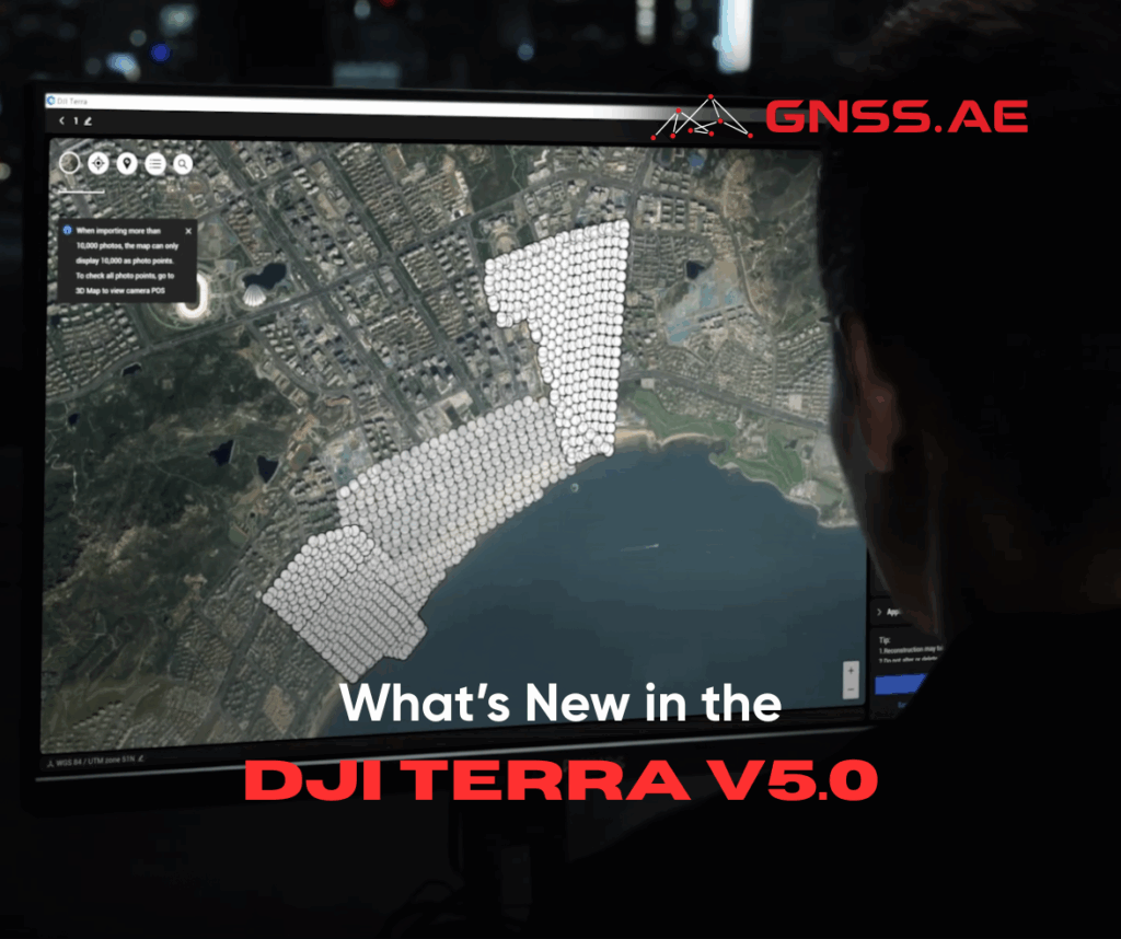
Released July 17, 2025, DJI Terra V5.0 sets a new standard for photogrammetry software with the introduction of 3D Gaussian Splatting and powerful new capabilities that streamline aerial surveying, enhance modeling accuracy, and accelerate large-scale data processing.
At the heart of the DJI Terra update is the 3D Gaussian Splatting—a powerful new reconstruction algorithm that redefines the way photogrammetry models are created. Unlike traditional oblique photogrammetry, Gaussian Splatting produces photo-realistic 3D models that faithfully represent complex environments, including transparent structures, fine architectural details, reflective surfaces, and vegetation. This technique delivers distortion-free orthomosaics and a natural rendering style, making it ideal for documenting cultural heritage, urban areas, scenic landscapes, and architectural assets.
Crucially, this technology isn’t just about aesthetics—it’s about performance. With the ability to process around 500 photos per hour, DJI Terra V5.0 can model large scenes (10,000 photos) in half the time compared to previous versions. The result: faster turnarounds for large-scale reconstruction projects.
DJI Terra now empowers users to perform city-scale 3D modeling with unmatched efficiency. Leveraging Gaussian Splatting and optimized memory utilization, the software can process 300–400 photos per 1 GB of RAM—supporting datasets of up to 30,000 images per modeling task. Whether capturing an entire city district, an industrial park, or a sprawling infrastructure network, DJI Terra delivers the scale and accuracy needed for urban digitalization and smart city planning.
Impressively, this level of performance is now accessible on entry-level hardware. With only 4 GB GPU memory and 32 GB RAM, professionals can execute high-quality modeling tasks without investing in high-perforamnce computing systems—expanding access to advanced 3D workflows.
To ensure seamless integration with industry ecosystems, DJI Terra supports one-click export to standardized 3D formats such as PLY and B3DM (3D Tiles). These outputs are ready for use across surveying, mapping, gaming, and film production environments, making Terra a highly versatile platform for spatial data processing and visual applications.
DJI Terra continues to be a top-tier solution for precision photogrammetry, capable of generating centimeter-level 2D/3D models without requiring ground control points. Integrated RTK positioning and intelligent reconstruction algorithms allow DJI Terra to meet the 1:500 mapping standard, even in complex terrain.
Users can control the level of detail with mesh density and resolution settings for point clouds, digital surface models (DSMs), and orthophoto maps.
Speed and efficiency are hallmarks of the DJI Terra software. For small projects, real-time on-site results are now possible. For larger-scale jobs, DJI Terra supports cluster processing, reducing modeling time dramatically. For example:
2D Reconstruction: 5,000 photos processed in under 2 hours (standalone) or 80 minutes (cluster reconstruction).
3D Modeling: 30,000 photos processed in 3 days using cluster mode.
Such capabilities make DJI Terra an optimal choice for industries with high-frequency data collection needs and urgent delivery schedules, such as emergency response, construction, and infrastructure monitoring.
DJI Terra V5.0 supports 2D–3D fusion modeling by integrating LiDAR and visible light data. A single acquisition using Zenmuse LiDAR can produce point clouds, 2D maps, and 3D mesh models, increasing model completeness—especially in structurally complex areas such as bridges and substations.
Leveraging RTK and PPK, Terra delivers centimeter-level accuracy for LiDAR point clouds without requiring ground control points. The software supports the automatic generation of waypoints and flight routes based on local 3D reality models or third-party point clouds. Users can visualize simulated camera views for precise waypoint selection and automated inspection planning.
New drone compatibility includes DJI Matrice 4T and Matrice 4TD, broadening support for inspection across industries.
For large-scale LiDAR data, DJI Terra handles 1 GB of point cloud data per 1 GB of RAM. A computer with 32 GB of RAM can process up to 120 GB of data, covering an area of around 10 square kilometers. Workstations with 128 GB of RAM are also supported for city-scale data processing.
In agriculture, DJI Terra continues to shine with robust support for multispectral imagery from DJI Mavic 3 Multispectral and Phantom 4 Multispectral. Users can generate vegetation index maps (NDVI, NDRE) and reflectance maps for plant health analysis.
More importantly, DJI Terra now facilitates variable-rate prescription mapping, allowing users to create crop-specific treatment plans (for field crops or fruit trees) and export them directly to DJI Agras drones. This end-to-end integration streamlines precision farming, maximizing yield while minimizing input costs.
DJI Terra is optimized for deep integration with DJI Enterprise hardware. When used with equipment like the DJI Matrice 4E, Matrice 400, Zenmuse P1, Zenmuse L2, and D-RTK 3, the software provides cost-effective visible-light and LiDAR mapping solutions across diverse scenarios.
Additionally, DJI Terra now enables direct model transfer to DJI Modify for editing. DJI Modify offers intelligent post-processing of mesh and point cloud models, including smoothing, noise reduction, downsampling, and classification. It can also output terrain results compatible with GIS and CAD systems, forming a complete workflow from data acquisition to editing and application.
With the updated DJI Terra sofware, DJI delivers a major leap forward in 3D modeling and aerial data processing. From the introduction of Gaussian Splatting to real-time on-site reconstruction, city-scale data handling, and deep hardware integration, this update establishes DJI Terra as a comprehensive platform for surveying, mapping, infrastructure, agriculture, and inspection workflows.
The result is a truly scalable, accessible, and professional-grade solution that streamlines the entire aerial surveying pipeline—from data collection to actionable insights.