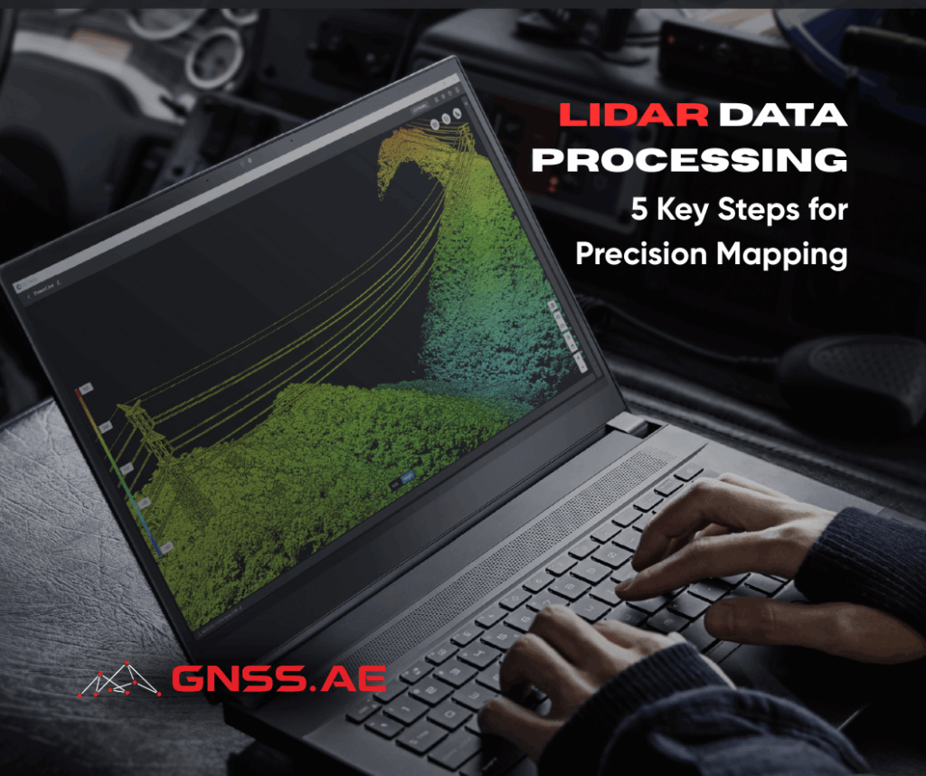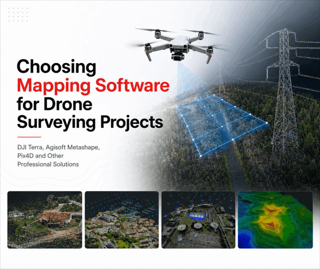
Drone mapping software has evolved far beyond simple image stitching. Today’s platforms generate survey-grade orthomosaics, point clouds, terrain models, 3D meshes, volumetric measurements, and, in many cases, support LiDAR, multispectral, and thermal datasets within a single workflow.
With dozens of solutions available, selecting the right platform depends on your projects, accuracy requirements, and preferred workflow. This article compares the leading drone mapping software for surveying professionals, highlights the strengths of each platform, and explains how to choose the best option for your needs.
Almost any drone mapping application can generate an orthomosaic, but professional surveying projects require much more.
The software must deliver reliable accuracy, support multiple sensor types, integrate with CAD, BIM, and GIS workflows, and process large datasets efficiently
Photogrammetric accuracy underpins every mapping deliverable. Modern software uses Structure-from-Motion (SfM) algorithms to reconstruct 3D geometry from overlapping images, and the quality of that reconstruction directly affects orthomosaics, point clouds, terrain models, and other outputs.
Differences between platforms lie in image alignment, camera calibration, bundle adjustment, and error correction. More advanced processing engines maintain geometric consistency across large projects and minimize distortion, particularly in complex terrain or dense urban environments.


RTK (Real-Time Kinematic) and PPK (Post-Processed Kinematic) positioning significantly improve survey accuracy by correcting GNSS measurements, typically reducing horizontal and vertical errors to just a few centimeters.
Workflow | Horizontal Accuracy | Vertical Accuracy |
Standard GNSS | 1–3 m | 2–5 m |
RTK | 1–3 cm | 2–5 cm |
PPK | 1–3 cm | 2–5 cm |
Although RTK-equipped drones can substantially reduce the number of Ground Control Points (GCPs) required, GCPs remain the standard method for validating accuracy on engineering, cadastral, and infrastructure surveys.
Professional mapping software should support:
Dataset size plays a major role in overall processing performance. While a small topographic survey may include only a few hundred images, corridor mapping, mining operations, or city-scale digital twin projects often involve more than 10,000 photographs or billions of LiDAR points.
Most platforms use one of two processing approaches.
Desktop processing performs reconstruction on a local workstation, providing full control over processing parameters, offline operation, and unrestricted access to raw data. Large projects, however, often require high-performance hardware, including multi-core CPUs, dedicated NVIDIA GPUs, 64–256 GB RAM, and fast NVMe SSD storage.
Cloud processing shifts reconstruction to remote servers, reducing hardware requirements and simplifying collaboration. The trade-offs include subscription costs, upload times for large datasets, internet dependency, and data security considerations.
Modern drone mapping extends far beyond standard RGB imagery. Depending on the project, operators may combine RGB, LiDAR, multispectral, and thermal data to generate more detailed and actionable geospatial products.
Professional mapping software should support multiple sensor types within a single workflow.

The value of mapping software lies not only in data processing but also in how easily results integrate with existing engineering workflows. Professional platforms should export standard formats such as GeoTIFF, LAS/LAZ, DXF, SHP, and OBJ/FBX, ensuring compatibility with CAD, BIM, and GIS software including AutoCAD, Civil 3D, ArcGIS, QGIS, and Revit.
Equally important is the ability to preserve coordinate systems, metadata, and georeferencing throughout the workflow, reducing unnecessary conversions and minimizing the risk of positional errors.
Before comparing individual software packages, it’s worth asking a simple question:
What problem are you actually trying to solve?
A surveyor creating cadastral maps values centimeter-level accuracy and robust coordinate handling above everything else. An infrastructure company inspecting bridges may prioritize high-quality 3D reconstruction and LiDAR integration. Agricultural specialists often need multispectral analysis and vegetation indices rather than dense point clouds, while construction firms usually focus on fast processing, progress tracking, and easy collaboration between engineers, project managers, and clients.
DJI Terra is designed specifically for DJI Enterprise drones, making it a practical choice for organizations that already rely on DJI hardware for surveying and mapping.
Category | Details |
Platform | Desktop software for photogrammetry and LiDAR processing, developed for DJI Enterprise drones. |
Supported Hardware | DJI Matrice 4E, DJI Matrice 400, DJI Zenmuse L3 and other DJI Enterprise payloads. |
Main Outputs | Orthomosaics, dense point clouds, Digital Surface Models (DSM), Digital Terrain Models (DTM), textured 3D meshes, contour maps, and volume calculations. |
Key Features | Native processing of DJI LiDAR datasets, RTK workflows, Ground Control Point (GCP) integration, check point validation, oblique image reconstruction and seamless processing of multi-flight datasets. |
Typical Applications | Topographic surveying, construction monitoring, mining, stockpile measurement, utility inspections, forestry, emergency response, and digital twin creation. |
Strengths | Tight integration with DJI Enterprise hardware, efficient processing of DJI datasets, native LiDAR support, offline desktop processing, and rapid support for new DJI sensors and payloads. |
Limitations | Designed primarily for DJI hardware, less suitable for mixed drone fleets, and available only for Windows. |
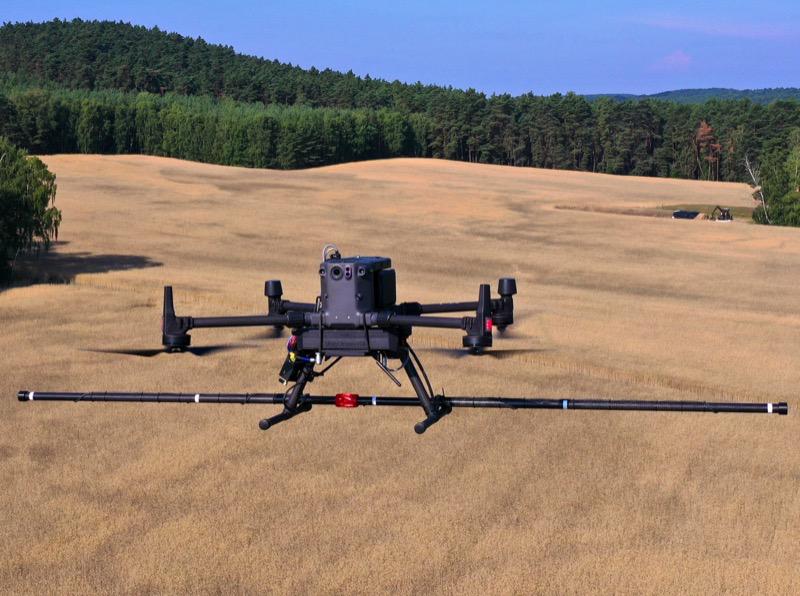
Large infrastructure projects particularly benefit from Terra’s ability to combine photogrammetry with LiDAR data.
For example, power transmission corridors often contain dense vegetation where conventional photogrammetry struggles to reconstruct the terrain. Processing LiDAR data captured with a Zenmuse L3 allows surveyors to generate accurate terrain models beneath tree canopies while simultaneously producing detailed 3D models of towers and conductors.

If DJI Terra is designed around workflow simplicity, Agisoft Metashape prioritizes flexibility and precise control over every stage of photogrammetric processing.
Used by geospatial professionals for more than a decade, Metashape has become one of the industry standards in surveying, archaeology, mining, forestry, and scientific research. Its image-based reconstruction engine is valued for producing consistent, high-accuracy results, particularly when working with large or complex dataset.
Category | Details |
Platform | Desktop photogrammetry software focused on high-accuracy image-based 3D reconstruction with extensive user control. |
Primary Outputs | Orthomosaics, orthophotos, dense point clouds, DSM, DTM, digital elevation models (DEM), textured 3D meshes, tiled models, and contour maps. |
Supported Workflows | RTK and PPK processing, Ground Control Points (GCPs), check points, camera calibration, multispectral and thermal imagery processing, Python scripting, and distributed network processing across multiple workstations. |
Large Project Support | Optimized for projects containing thousands of images while allowing detailed control over reconstruction quality and processing parameters. |
Advanced Controls | Feature detection, tie point filtering, dense cloud generation, mesh creation, texture resolution, coordinate systems, and camera optimization. |
Typical Applications | Cadastral surveying, mining, quarry volume calculations, archaeology, cultural heritage preservation, geological mapping, forestry, scientific research, and environmental monitoring. |
Strengths | Excellent reconstruction accuracy, highly configurable processing, powerful automation through Python scripting, efficient handling of large datasets, extensive export formats, and cross-platform support for Windows, macOS, and Linux. |
Limitations | Steeper learning curve than many commercial alternatives. Achieving optimal results often requires experience with processing parameters and workflow optimization. |
One of Metashape’s key advantages is its support for automation. Python scripting allows organizations to build repeatable processing workflows, reducing manual effort when handling large numbers of projects.
Metashape also performs well on large mapping projects involving thousands of images. Although processing is carried out locally and may take longer than some cloud-based platforms, users retain full control over reconstruction settings and output quality. For engineering, surveying, and scientific applications where positional accuracy is a priority, that level of control is often more important than shorter processing times.

Pix4D has become one of the most recognizable names in drone photogrammetry, largely because it offers not a single application but an ecosystem of specialized products.
Instead of trying to address every workflow through one interface, Pix4D separates surveying, agriculture, emergency response, and large-scale reconstruction into dedicated software packages.
Product | Primary Purpose | Typical Outputs / Features |
General photogrammetry for surveying, construction, mining, and infrastructure mapping. | Orthomosaics, DSM, DTM, dense point clouds, contour maps, textured 3D meshes, and volume calculations. | |
High-performance processing of very large aerial datasets. | Optimized for thousands of images with multi-core CPU and GPU acceleration, making it suitable for corridor mapping, city-scale projects, and digital twins. | |
Pix4Dfields | Precision agriculture and crop analysis. | NDVI, NDRE, crop vigor maps, field zoning, prescription maps, and multispectral analysis. |
Converting photogrammetric data into engineering deliverables. | Extraction of vectors, breaklines, terrain models, and CAD-ready outputs compatible with Civil 3D and other surveying software. |
Strengths

Unlike most commercial photogrammetry platforms, OpenDroneMap (ODM) is an open-source project developed and maintained by a global community of contributors. It enables organizations to process aerial imagery without recurring licensing costs while keeping both the software and the data under their own control. Its browser-based interface, WebODM, provides a user-friendly way to manage processing workflows through local or self-hosted deployment.
Category | Details |
Platform | Open-source photogrammetry software with the browser-based WebODM interface for local or self-hosted processing. |
Primary Outputs | Orthomosaics, DSM, DTM, point clouds, textured 3D meshes, contour maps, and volumetric measurements. |
Supported Workflows | RTK imagery, Ground Control Point (GCP) integration, local processing, Docker deployment, and self-hosted servers. |
Typical Users | Universities, municipal authorities, NGOs, research organizations, educational institutions, and small surveying companies. |
Strengths | No recurring license fees, complete data ownership, active open-source community, flexible deployment options, and support for standard photogrammetry products. |
Limitations | Installation, maintenance, and performance optimization require greater technical expertise. Processing speed depends heavily on available hardware. |
Because all processing takes place on local infrastructure, organizations maintain full control over their datasets. This makes OpenDroneMap particularly attractive for projects involving sensitive information or institutions that prefer self-hosted solutions over cloud-based services.

RealityCapture is a professional photogrammetry platform optimized for rapid large-scale reconstruction. Its reconstruction engine makes extensive use of GPU acceleration, allowing complex projects containing thousands of photographs to be processed significantly faster than with many traditional photogrammetry applications.
Area | Capabilities |
Core Processing | Ultra-fast image alignment, automatic camera calibration, high-density point clouds, detailed textured meshes, laser scan registration and hybrid reconstruction workflows. |
Surveying & Mapping | Quarry mapping, open-pit mining, large construction sites, infrastructure documentation, and digital twin generation. |
AEC & Industrial | Reconstruction of industrial facilities, bridges, transportation infrastructure, and complex engineering assets. |
Media & Entertainment | Film production, visual effects (VFX), game development, and digital heritage preservation. |
Best Suited For | Large projects requiring rapid reconstruction of highly detailed environments and objects. |
Strengths | Exceptional processing speed, excellent GPU utilization, high-quality mesh generation, strong scalability, and efficient hybrid LiDAR workflows. |
Limitations | Focuses primarily on reconstruction rather than complete surveying workflows. Coordinate management, survey validation, and CAD-oriented deliverables may require additional software. |
RealityCapture is particularly effective for reconstructing complex environments such as industrial facilities, bridges, historical buildings, and dense urban areas, where both geometric detail and processing speed are critical.

A survey-grade topographic survey prioritizes positional accuracy, while construction teams often need rapid progress updates. Agricultural specialists focus on vegetation analysis, whereas infrastructure operators increasingly rely on LiDAR and digital twins.
Below are some common workflows and the software that best supports them.
Recommended software:
Surveyors require centimeter-level accuracy, reliable coordinate management, and seamless integration with CAD and GIS platforms.
All three platforms support RTK and PPK workflows, Ground Control Points, and engineering-grade deliverables such as orthomosaics, terrain models, and dense point clouds.
For organizations operating primarily DJI Enterprise drones, Terra provides the shortest path from data collection to final deliverables.
Construction projects generate new datasets every week—or even every day. Software should process imagery quickly while producing reliable measurements for:
RealityCapture is particularly attractive for very large construction projects where reconstruction speed becomes a bottleneck.
Recommended software:
LiDAR continues to gain popularity because it performs reliably in environments where photogrammetry struggles.
Typical examples include:
Recommended software:
Precision agriculture relies less on highly detailed 3D reconstruction and more on extracting actionable information from multispectral imagery.
Vegetation indices such as NDVI or NDRE help growers identify crop stress, optimize irrigation, and improve fertilizer application.
For research projects requiring detailed terrain analysis alongside multispectral data, Metashape offers additional processing flexibility.
Infrastructure inspections increasingly involve combining RGB imagery, thermal cameras, and LiDAR.
Common applications include:
Fast reconstruction combined with detailed 3D models enables engineers to detect structural changes, measure deformation, and plan maintenance more efficiently.
Instead of asking which platform is “the best,” it is more useful to ask a series of practical questions.
Organizations operating DJI Enterprise aircraft will generally achieve the most streamlined workflow with DJI Terra.
Mixed fleets often benefit from more hardware-agnostic platforms such as Pix4D or Agisoft Metashape.
Standard RGB mapping can be handled by almost any professional platform.
However, projects involving LiDAR, multispectral cameras, or thermal payloads require software specifically designed to process these data types efficiently.
A survey containing several hundred images can be processed comfortably on most modern workstations.
City-scale digital twins, long corridor surveys, or large mining projects often require software optimized for thousands—or even tens of thousands—of images.
If multiple offices, contractors, or clients regularly collaborate on projects, cloud functionality may significantly improve productivity.
If data confidentiality is critical, desktop processing is usually the safer option.
Modern drone mapping software covers far more than image-based photogrammetry. Depending on the platform, it can support RTK and PPK workflows, LiDAR processing, multispectral analysis, automated classification, and direct integration with CAD and GIS environments.
Each solution is designed with different priorities in mind. DJI Terra is a natural choice for organizations working within the DJI Enterprise ecosystem, especially when processing LiDAR data from sensors such as the Zenmuse L3. Agisoft Metashape is well suited to projects that demand precise control over reconstruction workflows and survey-grade accuracy. Pix4D offers a broad ecosystem tailored to surveying, construction, and agriculture, while RealityCapture is known for its ability to process very large image datasets efficiently. For organizations that prefer self-hosted software and full control over their data, OpenDroneMap provides a capable open-source alternative.
The right software ultimately depends on your workflows, hardware, and project requirements. Factors such as sensor compatibility, processing speed, data security, export options, and long-term scalability are often just as important as reconstruction quality when selecting a platform.