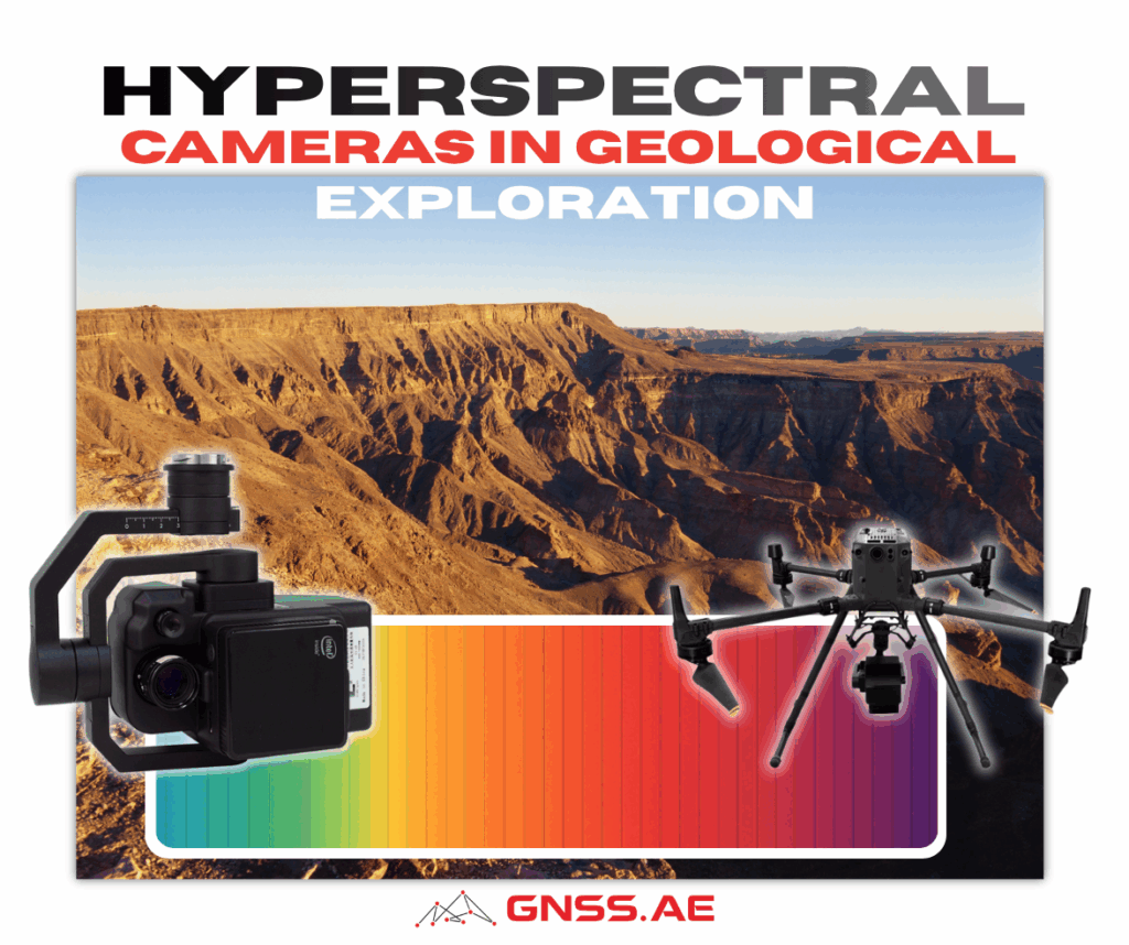
The mining and geological exploration industry has undergone a remarkable transformation in recent decades, driven largely by advances in remote sensing technology. Among these innovations, hyperspectral cameras have emerged as powerful tools that are revolutionizing how geologists detect, map, and characterize mineral deposits. By capturing hundreds of narrow spectral bands across visible, near-infrared, and thermal wavelengths, these sophisticated sensors enable researchers to identify minerals and geological features that would be invisible to the naked eye or traditional imaging systems.
Hyperspectral remote sensing combines two fundamental capabilities: imaging and spectroscopy. As described by Bedini (2017), this technology involves acquiring contiguous reflectance and emittance spectra from sensors mounted on airborne and spaceborne platforms. Unlike conventional cameras that capture just three broad color bands (red, green, and blue), hyperspectral sensors measure hundreds of spectral bands, providing detailed “spectral signatures” for different materials.
The technology works because minerals interact uniquely with electromagnetic radiation at different wavelengths. Electronic transitions and vibrational processes in minerals create diagnostic spectral features in the visible to shortwave infrared range (0.4-2.5 µm) and the thermal infrared region (8-12 µm). These spectral fingerprints allow geologists to remotely identify specific minerals and map their spatial distribution across large areas.

Hyperspectral sensors can be deployed on various platforms, each offering distinct advantages. Airborne platforms, such as aircraft equipped with sensors like NASA’s AVIRIS (Airborne Visible/Infrared Imaging Spectrometer), have been the workhorse of hyperspectral geological mapping for decades. These systems typically achieve spatial resolutions between 4 and 20 meters and can cover extensive areas efficiently.
However, recent innovations have expanded the toolkit significantly. Kirsch et al. (2018) demonstrate how integrating terrestrial (ground-based) and drone-borne hyperspectral sensors creates new opportunities for high-resolution geological mapping. Their research shows that unmanned aerial vehicles (UAVs) can acquire hyperspectral data at spatial resolutions ranging from millimeters to tens of centimeters—far exceeding what’s possible from traditional aircraft. This approach proves particularly valuable in areas with steep outcrops, restricted accessibility, or safety concerns that limit conventional fieldwork.
One of the most significant advantages of modern hyperspectral systems is their ability to capture data across multiple wavelength ranges, each revealing different geological information.
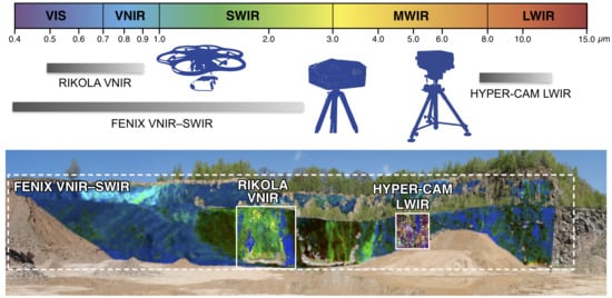
Visible to Near-Infrared (VNIR, 0.4-0.9 µm): This range is sensitive to iron oxides, hydroxides, and sulfates, as well as rare earth elements. These minerals often indicate weathering processes or mineralization zones.
Shortwave Infrared (SWIR, 0.9-2.5 µm): Perhaps the most widely used range in mineral exploration, SWIR imagery excels at identifying alteration minerals such as phyllosilicates (clays and micas), hydroxylated silicates, sulfates, carbonates, and ammonium minerals. These “alteration minerals” frequently serve as pathfinders to ore deposits, as they form in the same hydrothermal systems that create economically valuable mineralization.
Long-Wave Infrared (LWIR, 7.7-11.8 µm): This emerging technology represents a frontier in geological remote sensing. As Kirsch et al. (2018) explain, LWIR hyperspectral imaging complements VNIR-SWIR data by detecting molecular vibrations of rock-forming minerals like quartz and feldspars—minerals that lack distinctive features in shorter wavelengths. This capability enables geologists to discriminate between different rock types, such as marbles, quartzites, or various generations of intrusive rocks, that appear identical in standard photographs.
Hyperspectral remote sensing has proven valuable for exploring numerous types of mineral deposits. According to Bedini’s (2017) comprehensive review, the technology has found successful application in studying and exploring:
The review also identifies deposit types where hyperspectral technology remains underexplored, including chromite deposits, nickel sulfides in ultramafic rocks, rare-metal pegmatites, and uranium deposits in sedimentary basins, suggesting opportunities for future research and application.
One of the most exciting developments in hyperspectral geological mapping is the integration of spectral data with three-dimensional outcrop models. Kirsch et al. (2018) present an innovative workflow that combines hyperspectral imagery with Structure-from-Motion Multi-View Stereo (SfM-MVS) photogrammetry to create “hyperclouds”—geometrically accurate 3D representations enriched with spectral information.
This integrated approach offers several advantages over traditional methods:
The practical value of hyperspectral remote sensing for mineral exploration is demonstrated by Rahman’s (2024) work in Saudi Arabia’s mineral-rich terrain. The study focused on the Mahd adh Dhahab region, an area with significant historical mining activities and known deposits of gold, copper, and other valuable minerals.
Rather than deploying specialized hyperspectral aircraft or drones, Rahman utilized ASTER (Advanced Spaceborne Thermal Emission and Reflection Radiometer) satellite imagery processed through Google Earth Engine (GEE)—demonstrating how accessible cloud-based platforms are democratizing hyperspectral exploration technology.
The study leveraged ASTER’s unique capabilities in the Shortwave Infrared (SWIR) and Thermal Infrared (TIR) ranges, which are particularly well-suited for detecting mineral compositions due to their distinctive spectral signatures. Key techniques employed included:
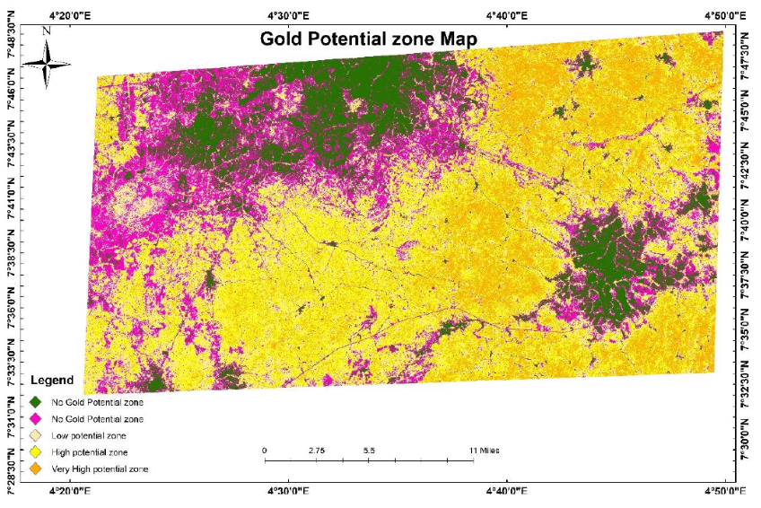
The above visualization demonstrates how hyperspectral remote sensing can efficiently identify and prioritize exploration targets across large areas, helping geologists focus field investigations on the most promising zones while minimizing costs and exploration risks.
The research successfully identified hydrothermal alteration zones commonly associated with gold and other mineral deposits. By overlaying the results with known deposit locations, Rahman validated the accuracy and reliability of the remote sensing approach. This case study demonstrates that effective mineral exploration using hyperspectral techniques doesn’t always require expensive airborne campaigns—satellite-based imagery processed through accessible platforms like Google Earth Engine can provide valuable reconnaissance-level information with minimal field data and lower costs.
The adoption of hyperspectral technology in mineral exploration and mining operations offers compelling benefits:
Safety: Remote sensing allows characterization of dangerous, unstable, or inaccessible terrain without exposing personnel to risk.
Efficiency: As noted by Bedini (2017), an airborne hyperspectral survey can reveal zoning patterns and mineral assemblages that might take years to find through conventional methods—or might never be found at all.
Statistical rigor: Complete spatial coverage enables more representative sampling strategies, as geologists can target specific spectral anomalies rather than relying on limited, potentially biased sample locations.
Speed: Modern processing workflows, including machine learning algorithms and batch processing routines, can generate preliminary geological maps shortly after data acquisition, enabling rapid decision-making in the field.
Versatility: The same datasets support multiple analytical approaches, from simple band ratios to sophisticated unmixing algorithms, allowing geologists to extract different types of information as projects evolve.
Despite its tremendous potential, hyperspectral remote sensing faces certain limitations that practitioners must consider:
Spatial resolution: While airborne systems typically achieve resolutions of 4-20 meters, and drone-based sensors can reach centimeter-scale detail, planned satellite hyperspectral missions will offer only moderate resolution (around 30 meters). This may limit their effectiveness for detailed deposit-scale mapping, though they will excel at regional reconnaissance.
Validation requirements: Hyperspectral data must be validated through ground truthing, including field observations, petrographic analysis, and geochemical sampling. Remote sensing supplements rather than replaces traditional geological fieldwork.
Atmospheric and topographic effects: Hyperspectral data requires careful correction for atmospheric interference and topographic influences, necessitating sophisticated processing workflows.
Cost: While becoming more accessible, airborne hyperspectral surveys still represent significant investments. As Bedini (2017) notes, they are best applied where commitments to a property or district are strong.
Indirect detection: Most ore metals lack distinctive spectral features in the visible to thermal infrared range. However, associated alteration minerals provide excellent proxies and pathfinders for mineralization.
The future of hyperspectral remote sensing in geological exploration appears bright, with several promising developments on the horizon:
Improved satellite systems: Future spaceborne hyperspectral missions will make this technology more widely available to researchers and exploration companies worldwide, enabling cost-effective reconnaissance over vast areas.
Miniaturization: Ongoing sensor development is producing smaller, lighter hyperspectral cameras that can be deployed on increasingly compact drone platforms.
Machine learning integration: Advanced algorithms are improving classification accuracy by fusing topographic and spectral data, automating mineral identification, and reducing processing time.
Real-time processing: Emerging hardware and software solutions promise near-instantaneous processing of photogrammetric and hyperspectral data, allowing geologists to view preliminary results while still in the field.
3D resource modeling: Integration of hyperspectral surface data with subsurface information from drill cores and geophysics will enable fully three-dimensional structural and mineral resource models.
Hyperspectral cameras represent a transformative technology in geological exploration and mining. By revealing the invisible spectral signatures of minerals across visible, near-infrared, and thermal wavelengths, these sensors enable geologists to map alteration zones, discriminate rock types, and identify mineralization vectors with unprecedented detail and efficiency.
The integration of multi-platform hyperspectral imaging—from satellites to aircraft to ground-based systems and drones—with three-dimensional photogrammetric models creates a powerful framework for modern geological investigation. This approach enhances safety, improves sampling strategies, accelerates discoveries, and provides statistically robust datasets for resource evaluation.
As Kirsch et al. (2018) demonstrate, the combination of terrestrial and drone-borne multi-sensor remote sensing techniques significantly improves the reliability, safety, and efficiency of geological activities during both exploration and mining monitoring. While hyperspectral technology will not replace traditional fieldwork, it has become an indispensable complement to conventional geological methods, offering insights that would be difficult or impossible to obtain otherwise.
For exploration companies, research institutions, and mining operations, hyperspectral remote sensing is no longer an exotic experimental technology—it is an established tool delivering tangible results. As sensors improve, costs decrease, and processing becomes more automated, hyperspectral cameras will play an increasingly central role in discovering and developing the mineral resources that society needs.
Bedini, Enton. (2017). The use of hyperspectral remote sensing for mineral exploration: a review. Journal of Hyperspectral Remote Sensing. 7. 189. 10.29150/jhrs.v7.4.p189-211.
Kirsch, M., Lorenz, S., Zimmermann, R., Tusa, L., Möckel, R., Hödl, P., Booysen, R., Khodadadzadeh, M., & Gloaguen, R. (2018). Integration of Terrestrial and Drone-Borne Hyperspectral and Photogrammetric Sensing Methods for Exploration Mapping and Mining Monitoring. Remote Sensing, 10(9), 1366. https://doi.org/10.3390/rs10091366
Rahman, M. M. (2024). Mapping mineral potential zones using hyperspectral imagery in Google Earth Engine: A case study from Saudi Arabia.