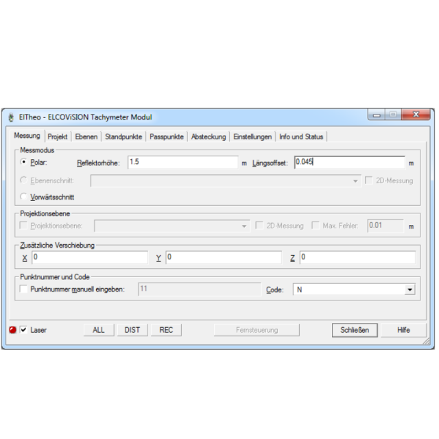
ELCOVISION 10 ElTheo is a “device driver” for total stations with serial or Bluetooth interface, which enables a CAD program to communicate directly with the total station. The main advantage is that every function of the CAD system becomes a measurement function. The total station can be used like a 3D Digitizer. A digital 3D drawing of the object is created on site. Visit our website to download a evaluation version of ELCOVISON ELTheo!

Inquire Now
ELCOVISION 10 ElTheo is a “device driver” for total stations with serial or Bluetooth interface, which enables a CAD program to communicate directly with the total station. The main advantage is that every function of the CAD system becomes a measurement function. The total station can be an be used like a 3D Digitizer. A digital 3D drawing of the object is created online.
The integration of the measuring instrument into the CAD environment also offers the advantage that design and measurement are one. However, not only 3D measurement is supported, but also distances measured with a folding rule or the Leica DISTO can be incorporated without any additional effort.
ELCOVISION 10 ElTheo offers multiple methods to stationing a total station and supports multiple measurement modes like polar measurement, plane intersection and forward intersection.
ELCOVISION 10 ElTheo is seamlessly integrated into AutoCAD 2019-2022 and BricsCAD V19-V22 and offers multiple additional drawing functions especially suited for 3d reconstruction.
|
Data management |
|
| Save standardization for drawings/maps | |
| Spatial reference system | |
|
Geometry types |
|
| Points | Point, Multipoint, Symbol, Text |
| Lines | Line segment, Polyline, Multiline, Arc, B-spline, Others |
| Surfaces | Polygon, Circle, Multipolygon, Others |
|
Other |
|
| License or freeware | License |
| Training | Y |
| Main users | Surveyors, Architects, Archaeologists, Craftsman |
| Main applications | 3D Plans, Floor Plans, Documentation |
| Extensions | none |
| Related products | ELCOVISION 10 Photogrammetry |
|
2D Editing |
|
| Select | By drawing attributes, Select by administrative attributes, Spatial selection, Multiple select, Others |
| Remove | |
| Graphic transformations | |
|
2D Construction |
|
| Positioning on virtual raster | Y |
| Positioning by coördinates | Y |
| Positioning by snapping | Y |
| Positioning by Dimensions | Y |
| Positioning in relation to other element | Parallel, Extend, Collinear, Perpendicular, Particular angle, Others |
|
Storage |
|
| Type of data storage | File, Database |
| Native storage format | DWG, DXF |
| Input formats | Dwg, Dxf, Jpg, Others |
| Export formats | Dwg, Dxf, Others |
|
Visualisation |
|
| Types | Color, Pattern, Hatch, Gradient color |
| Change view | Zoomfactor, Target point, Twist angle |
|
Data analysis |
|
| Merge | Others |
| Measurement | |
| Topology | Others |
| Clip | Y |
|
Interoperability |
|
| Web standards | None |
| Spatial database management systems | None |
| Messaging protocols | None |
| Extensions | None |
| Publish standards | None |
|
General |
|
| Year of introduction | 1998 |
| Year of last update | 2022 |
| Supported operation system | Windows |
Inquire price for ELCOVISION ELTheo