DJI Terra

DJI Terra is 3D model reconstruction software that has photogrammetry as its core technology. It supports a range of accurate and efficient 2D and 3D reconstruction of visible light, and data processing through DJI LiDAR.
DJI Terra is a perfect match for DJI Enterprise drones and payloads. It works in conjunction to build a complete application solution that caters to verticals such as land surveying and mapping, power transmission, emergency services, construction, transportation, and agriculture.

Features

DJI Terra

Make the World Your Digital Asset

DJI Terra is 3D model reconstruction software that has photogrammetry as its core technology. It supports a range of accurate and efficient 2D and 3D reconstruction of visible light, and data processing through DJI LiDAR.
DJI Terra is a perfect match for DJI Enterprise drones and payloads. It works in conjunction to build a complete application solution that caters to verticals such as land surveying and mapping, power transmission, emergency services, construction, transportation, and agriculture.

Area Mapping

3D Models

Realistic 3D models can be generated in three resolutions—high, medium and low. Water surfaces in the model are automatically optimized through AI technology, and the formats commonly used in the industry are exported for image reconstruction in diverse scenarios, such as surveying and mapping, accident sites, power grid equipment, and progress-tracking for construction projects.

400 photos/1GB

(single computer)

Scale

6,000 photos/1GB

(cluster processing)

30,000 photos/3 days

(single computer)

Efficiency

30,000 photos/21 hours

(cluster processing)

Accuracy

Centimeter-level accuracy

2D Maps

The algorithm is optimized according to the different scenarios to significantly improve processing efficiency, effectively avoid image warping and deformation, and obtain detailed and accurate measurement results for all your target objects and survey areas.

400 photos/1GB

(single computer)

Scale

6,000 photos/1GB

(cluster processing)

5,000 photos/2 hours

(single computer)

Efficiency

5,000 photos/80 minutes

(cluster processing)

Accuracy

Centimeter-level accuracy

LiDAR

With just one click, you can perform highly accurate processing of the point cloud data captured by the Zenmuse LiDAR in DJI Terra, including route calculation, precise fusion of point cloud and visible light data, optimization of point cloud accuracy, ground point extraction, DEM generation, and mission report output.

Multispectral

Using multispectral data from DJI Mavic 3 Multispectral and P4 Multispectral, vegetation index maps including NDVI and NDRE can be produced to provide insight into plant growth and health, radiometric correction is supported and reflectance maps can be generated for remote sensing research. Prescription maps can be created for variable rate application using DJI’s Agras drones to improve crop yields while driving down costs.

DJI Terra and DJI Modify Seamless Workflow

With one click, DJI Terra can launch DJI Modify. DJI Terra can also easily generate files for model editing with another click. These simple steps make the subsequent model editing process quick and convenient. DJI Modify is DJI’s first intelligent 3D model editing software. It features a streamlined and intuitive interface that is simple to use to complete 3D model editing efficiently. It accurately identifies floating parts, holes, and vehicles in the models. Mesh can be repaired with a single click, with true-to-life textures generated quickly, significantly simplifying the model editing process. Paired with a DJI Enterprise drone and DJI Terra, it forms a comprehensive solution from aerial surveying, modelling, and model editing to sharing these models easily to meet operational needs in surveying and mapping, firefighting, emergency response, and transportation.

More highlights

With one click, DJI Terra can launch DJI Modify. DJI Terra can also easily generate files for model editing with another click. These simple steps make the subsequent model editing process quick and convenient. DJI Modify is DJI’s first intelligent 3D model editing software. It features a streamlined and intuitive interface that is simple to use to complete 3D model editing efficiently. It accurately identifies floating parts, holes, and vehicles in the models. Mesh can be repaired with a single click, with true-to-life textures generated quickly, significantly simplifying the model editing process. Paired with a DJI Enterprise drone and DJI Terra, it forms a comprehensive solution from aerial surveying, modelling, and model editing to sharing these models easily to meet operational needs in surveying and mapping, firefighting, emergency response, and transportation.

Seamless Workflows, Accurate Results

Unparalleled efficiency and user experience

A simple and intuitive interface that gets you flying in no time.

Run reconstruction missions by employing multiple graphics cards simultaneously to improve efficiency.

Meet and exceed your project standards

Incorporate POS data, GCPs, or both sets of data to create georeferenced maps and models with enhanced accuracy directly in the target coordinate system required by the project.

Convert the coordinates of your maps and models into 8500+ major coordinate systems by simply selecting the output that fits your needs.
View a quality report of your mission to ensure the results meet your accuracy standards.

Support the auto GCPs for automatic identification of more photos with marking points by simply marking one photo.

With the Region of Interest (ROI) and block, image reconstruction can be performed to specific target region. In turn, this saves processing time and improves efficiency, while generating a clearer model or point cloud, and completing the large-scale block reconstruction and montage.

Intuitive and Effortless

Acquire key dimensions across an array of terrains with easy-to-use analysis tools that enable you to obtain a variety of measurement data based on linear, area and volumetric measurements.

Edit labels of measurements on existing models, which can be used for reporting and improving communication throughout ongoing projects.

Mission Planning

Digitize the World Around You

Surveying and Mapping

A groundbreaking aerial survey solution that takes automation and data utilization to a whole new level, delivering unparalleled cost benefits and efficiency to mapping professionals.

Transforming the Power Industry

The refined modeling of power cables, poles, transmission towers, and other infrastructure revamps automated inspections and galvanizes the digital transformation of electrical grids.

Public Safety

DJI Terra facilitates customers in the public safety sector in make scientific decisions with advanced 3D situational awareness and by harnessing key on-site information.

Revolutionizing Oil and Gas

DJI Terra plays a crucial role in site management, pipeline inspection, and prospecting operations, by improving productivity while reducing business costs, bringing unprecedented change to the technology of the energy industry.

Specification

Terra License Plans

Feature/Version Agriculture Pro

Electricity

Cluster

Education

Real-time 2D Mapping
Agricultural application
2D Reconstruction (Field)
2D Multispectral Reconstruction
2D Reconstruction (Urban)
KML file import
Output Coordinate System
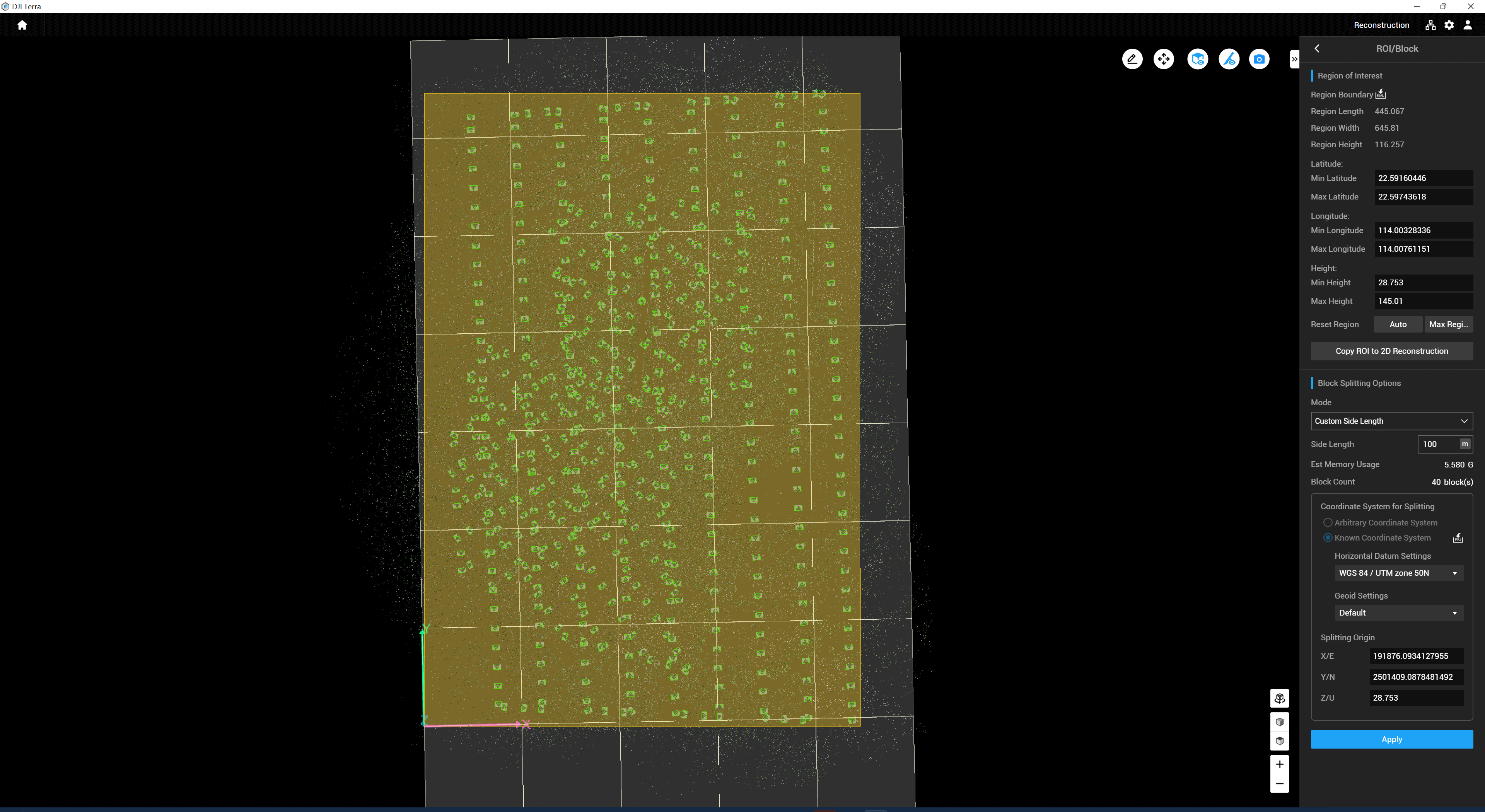
ROI Reconstruction
Image POS import
Multi-GPU Reconstruction
3D Reconstruction
3D Mission planning
Real-time 3D Mapping
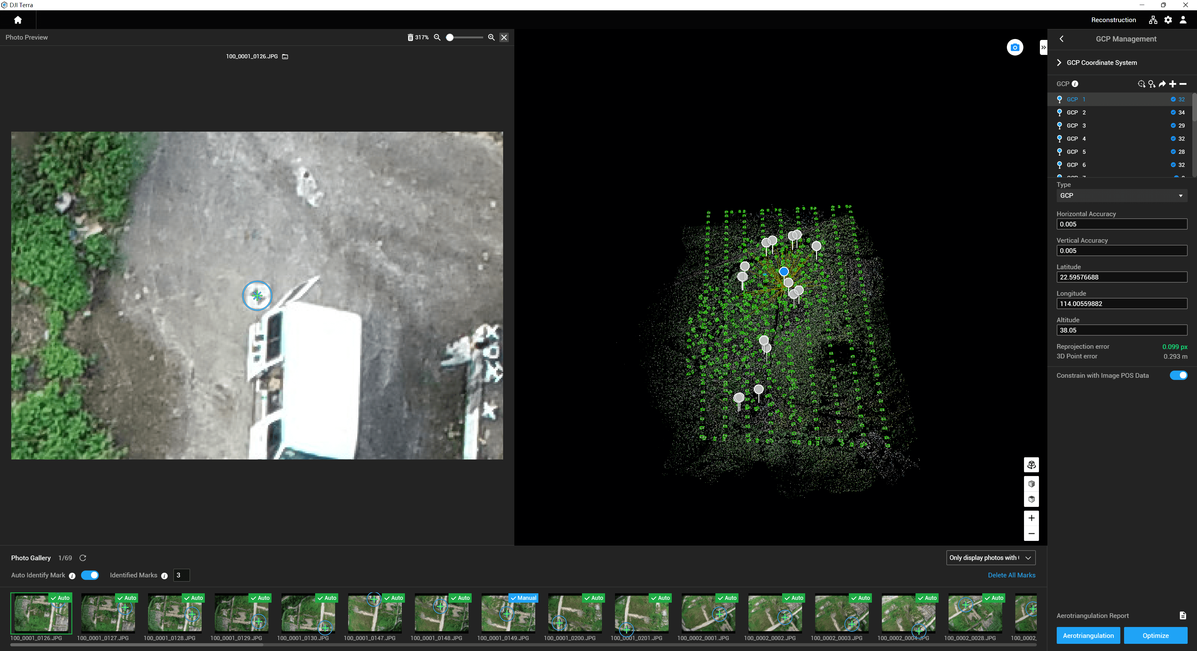
GCPs
LiDAR Point Cloud Accuracy Optimization
LiDAR Point Cloud Smoothing
Categories of ground points of LiDAR point cloud
Electricity Application
Detailed Inspection
Cluster Computation
Bind Device 16 3 devices 1 device 1 device 1 Device 3 nodes Contact Us
Authorization mode13 Online Online/Offline Online Offline Online
Validity Period 1 year 1 Year / Permanent14 (Free update for the first year, paid update from
the next year)
1 year Permanent14(Free update for the first year, paid update from the next year) Permanent

Download brochure

    By submitting this message, you agree with the privacy policy and the processing of personal data.


    * - required fields

    Inquire price for DJI Terra