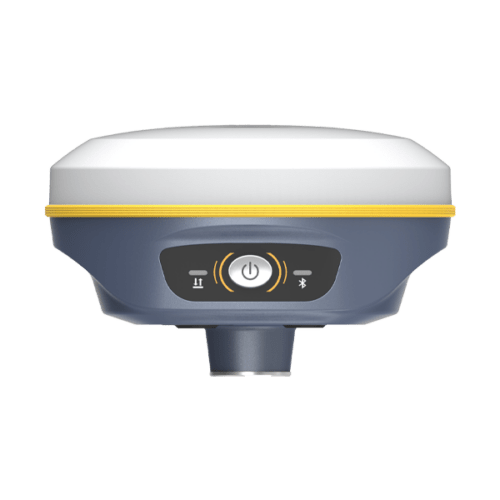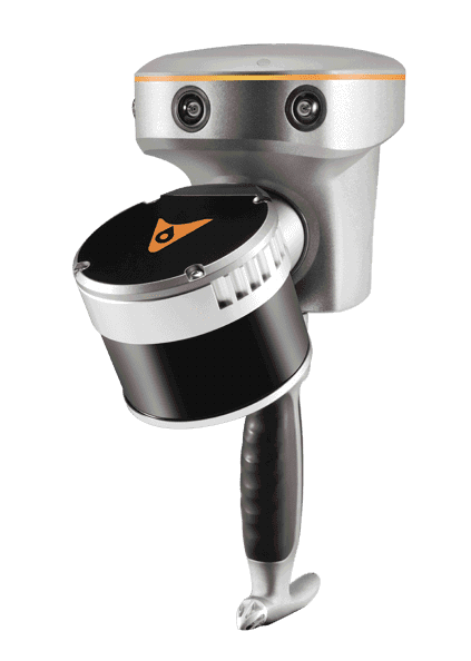
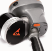
The RS10 combines GNSS RTK, laser scanning, and visual SLAM technologies for precise 3D scanning and surveying in diverse environments, offering versatility and accuracy for professionals in surveying, civil engineering, construction, mining, and other industries.
The RS10 brings a new approach to geospatial surveying by integrating GNSS RTK, laser scanning
and visual SLAM technologies into a single platform designed to improve the efficiency and accuracy of indoor and outdoor 3D scanning and surveying tasks. The RS10 is a versatile solution for surveying, civil engineering and BIM professionals, as well as for applications such as agricultural and forestry surveying, power line inspection, material pile volume calculation and data collection in underground spaces. With the RS10, surveyors are able to overcome the challenges of surveying in areas with poor or no GNSS signals, bringing a new level of flexibility and accuracy to their work. By supporting both traditional GNSS RTK surveying and innovative 3D reality capture, the RS10 simplifies fieldwork and improves data reliability.
The RS10 is the result of CHCNAV’s expertise in GNSS technology development. Featuring a 4th generation air dielectric GNSS antenna, it provides RTK positioning accuracy of better than 3 cm in a variety of challenging environments. Combined
with the system’s high-precision LiDAR and three HD cameras, it fuses RTK, laser and visual SLAM to deliver 5 cm absolute measurement accuracy. From detailed architectural surveys to complex infrastructure projects, the RS10 gives professionals the tools they need to efficiently collect rich and accurate data.
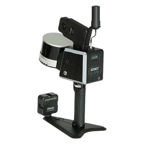
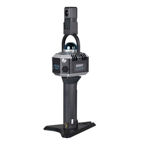
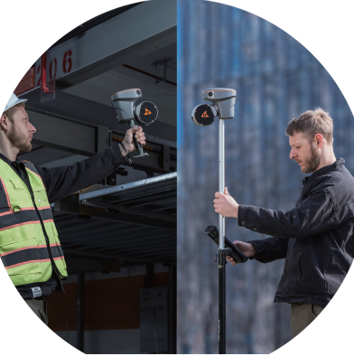
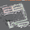
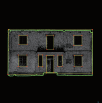
Equipped with a powerful on-board processor, the RS10 provides real-time SLAM (Simultaneous Localization and Mapping) capabilities to create georeferenced point clouds directly in the field without the need for post-processing. With immediate feedback on the collected data, users can make adjustments on the fly to ensure complete and detailed scan coverage. The RS10 can map large areas up to 13,000 square meters in real time, making it ideal for rapid or complex surveying projects where time and accuracy are critical.
The integration of high-precision GNSS and SLAM technologies eliminates the need for traditional loop closure, which often complicates the data collection process for handheld scanners. By enabling loop-free path planning, the RS10 streamlines field data collection and significantly reduces the time and effort required to complete projects.
The RS10’s Vi-LiDAR technology offers a
new mode of RTK surveying that combines
GNSS rover capabilities with laser scanning for contactless offset measurements. By simply selecting the point to be measured in the image scene of LandStar™ software, its threedimensional coordinates are calculated in real time from the intersection of the RTK-origin line and the LiDAR point cloud to an accuracy of 5 cm within 15 m (50 ft).
Operates in rover mode with CHCNAV LandStar™ software for easy use and minimal training.
Runs for 60 minutes on a single battery, allowing for easy replacement without powering off the unit.
When used as a SLAM scanner, SmarGo provides real-time accuracy information for on-thespot improvement.
Using the CHCNAV software ecosystem, the RS10 data can be sent to CoProcess for instant drawing extraction.
The RS10 brings a new approach to geospatial surveying by integrating GNSS RTK, laser scanning, and visual SLAM technologies into a single platform designed to improve the efficiency and accuracy of indoor and outdoor 3D scanning and surveying tasks. The RS10 is a versatile solution for surveying, civil engineering, and BIM professionals, as well as for applications such as agricultural and forestry surveying, power line inspection, material pile volume calculation, and data collection in underground spaces.
With the RS10, surveyors are able to overcome the challenges of surveying in areas with poor or no GNSS signals, bringing a new level of flexibility and accuracy to their work. By supporting both traditional GNSS RTK surveying and innovative 3D reality capture, the RS10 simplifies fieldwork and improves data reliability.

General System Performance |
||
| Absolute accuracy | H: < 5 cm RMS(1) V: < 5 cm RMS(1) |
|
| Relative accuracy | <1 cm | |
| Power supply mode | Lithium battery, supports hot-swapping and portable charger | |
| Working time from a single battery(2) | 1 h | |
| Data storage | 512 GB | |
| Field of view | 360° × 270° | |
| Weight | 1.9 kg (including RTK and battery) | 1.7 kg (including RTK and battery) |
| Loop-free data acquisition | Yes | |
| Real-time accuracy assessment | Yes | |
Laser Scanner |
||
| Laser product classification | Class 1 Eye Safe | |
| Range | 0.5 to 120 m | 0.5 to 300 m |
| Channel | 16 | 32 |
| Point cloud thickness | 2 cm | 1 cm |
| Range capability | 80 m @10% reflectivity (Channels 5 to 12) 50 m @10% (Channels 1 to 4, 13 to 16) | 80 m @10% Reflectivity |
| FOV (Horizontal) | 360° | |
| Horizontal angle resolution | 0.18° (10 Hz) | |
| FOV (Vertical) | 30° (-15° to +15°) | 40.3°(–20.8° ~ +19.5°) |
| Max. effective measurement rate | 320,000 points/sec | 640,000 points/sec |
| Selectable scan speed | 10 Hz | |
| Max. Number of return pulses | 2 | |
| Wavelength | 905 nm | |
GNSChannelsS Performance(3) |
||
| Channels | 1408 channels with iStar2.0 | |
| GPS | L1C/A, L2C, L2P(Y), L5 | |
| GLONASS | L1, L2, L3* | |
| Galileo | E1, E5a, E5b, E6* | |
| BeiDou | B1I, B2I, B3I, B1C, B2a, B2b | |
| QZSS | L1C/A, L1C, L2C, L5, L6* | |
| NavIC/IRNSS | L5* | |
| PPP | B2b-PPP | |
| SBAS | EGNOS (L1, L5) | |
GNSS Accuracies |
||
| Real time kinematic | H: 8 mm + 1 ppm RMS (RTK)(4)
V: 15 mm + 1 ppm RMS Initialization time: <10 s Initialization reliability: >99.9% |
|
| Post-processing kinematic (PPK) | H: 3 mm + 1 ppm RMS
V: 5 mm + 1 ppm RMS |
|
| PPP | H: 10 cm
V: 20 cm |
|
| High-precision static | H: 2.5 mm + 0.1 ppm RMS
V: 3.5 mm + 0.4 ppm RMS |
|
| Static and rapid static | H: 2.5 mm + 0.5 ppm RMS
V: 5 mm + 0.5 ppm RMS |
|
| Code differential | H: 0.4 m RMS
V:0.8 m RMS |
|
| Visual-assisted positioning | Yes | |
IMU |
||
| IMU update rate | 200 Hz | |
| Auto initialization | Yes | |
| Attitude accuracy after post-processing | 0.005° RMS pitch/roll,
0.010° RMS heading |
|
| Position accuracy after post-processing | 0.010 m RMS horizontal,
0.020 m RMS vertical |
|
Camera |
||
| Number of cameras | 3 | |
| Resolution | 15 MP (5 MP*3) | |
| Sensor size | 2592 (H) × 1944 (V) | |
| Pixel size | 2.0 µm | |
| FOV | 210° × 170° | |
Environments |
||
| Operating temperature | -20°C to +50°C | |
| Storage temperature | -20°C to +60°C | |
| Ingress protection | IP64(5) (according to IEC 60529) | |
| Humidity (operating) | 80%, non-condensing | |
Electrical |
||
| Input voltage | 9 – 20 V DC | |
| Power consumption | <30 W | |
| Battery capacity | 24.48 Wh | |
Equipped Software |
||
| SmartGo software | Data acquisition control, real-time point cloud display,etc | |
| CoPre intelligent processing software | POS process, Adjust & Refine, Generate point cloud, modeling, etc | |
| CoProcess efficient feature extraction software | Building feature extraction, road feature extraction, volume calculation, etc | |
| LandStar Field Survey APP | Topographic survey, Point stakeout, Line stakeout, Elevation check, Facade survey | |
Inquire price for CHCNAV RS10