As modern GIS workflows increasingly depend on centimeter-level accuracy, a solid understanding of geodetics has become essential for professionals working with high-precision GNSS data. Accurate coordinates do not come from hardware alone. They rely on correct datums, epochs, transformations and projections configured throughout the workflow. A single mismatch can introduce errors large enough to compromise entire datasets.
This article explores the fundamentals of coordinate systems and geodetic principles, highlights common configuration challenges, and explains why proper geodetic setup is critical for reliable GIS data collection.
To understand how coordinate systems influence GIS data accuracy, it’s important to review several foundational geodetic concepts.

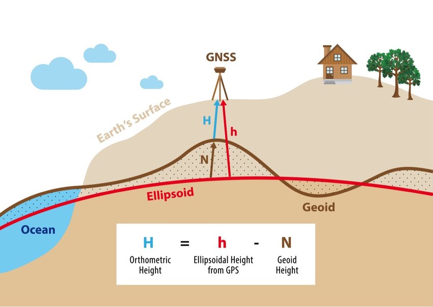
A datum provides a reference model for describing locations on Earth. Most GNSS systems rely on global, Earth-centered datums such as WGS84 or ITRF, which represent the Earth using an ellipsoid and define coordinates in latitude, longitude and ellipsoidal height.
However, global datums are dynamic—coordinates change over time due to tectonic plate movement.
Local datums, on the other hand, are often fixed to a region where tectonic motion is uniform. These static datums maintain consistent coordinates over long periods, making them suitable for countries like Australia. Some modern local datums are also dynamic, updating coordinates over time to reflect surface motion.
An epoch specifies the moment in time to which coordinates are referenced. Epochs are critical for dynamic datums because the Earth’s surface is constantly moving. For example, two coordinates collected at different epochs may differ even if measured at the same physical location.
Including epoch information ensures accurate comparison, transformation and integration of spatial data.
A datum transformation converts coordinates from one reference frame to another. Transformations range from simple XYZ shifts to complex conversions involving rotation, scale and time-dependent parameters.
For dynamic datums, time-dependent transformations are essential because tectonic plate movement must be accounted for when converting between epochs.
GNSS provides heights relative to the WGS84 ellipsoid, not mean sea level. To convert these to orthometric heights, a geoid model is required. This correction aligns GNSS-measured heights with vertical datums commonly used in engineering, surveying and infrastructure applications.
Projections translate the Earth’s curved surface onto a flat map. Every projection introduces distortion—whether of area, shape or distance. Selecting an appropriate projection ensures spatial data is represented correctly for the intended use.
Achieving high-accuracy GNSS results relies on differential correction, where a base station with a known position calculates and broadcasts corrections to field GNSS receivers. This can occur in real time (RTK, VRS) or after data collection (post-processing).
A critical geodetic principle is that the corrected output inherits the reference frame and epoch of the base station.
For example, if the base station is defined in ETRS89, the corrected rover data will also be referenced to ETRS89.
Because correction services typically maintain modern datums and realizations, inconsistencies often arise when integrating their outputs into older GIS systems. Therefore:
Always confirm the reference frame and epoch of your correction source before beginning fieldwork.
Incorrect or missing transformations at this stage are among the most common causes of positional error.
Understanding geodetics is only half the challenge—proper configuration is essential for maintaining accuracy across the workflow.
Accurate QA/QC requires comparing field results to trusted control points. National geodetic agencies maintain authoritative benchmarks, but existing GIS datasets may vary in quality or lack clear lineage.
Legacy datasets may have been visually adjusted rather than accurately georeferenced. Meanwhile, site calibrations used in local surveys may not align with national or regional reference frames. Always evaluate the coordinate system, accuracy and history of any reference dataset.
Misconfigured coordinate systems can cause field data to appear:
Typical issues include:
Since horizontal and vertical coordinate systems are often configured separately, Z-value errors are common and can significantly affect 3D or engineering applications.
Missing or incorrect transformations can introduce coordinate shifts of several meters. High-accuracy GNSS workflows often involve multiple coordinate systems—including the GIS database, field software and correction source—each requiring properly configured transformations.
Before starting production data collection, it is essential to test your configuration using known control points.
Even with correct configurations, certain limitations remain:
In regions near plate boundaries or areas undergoing crustal deformation, ignoring epoch or deformation models can result in significant positional discrepancies.
As demand for high-accuracy GIS data grows across sectors—from infrastructure and utilities to environmental monitoring—geodetic literacy is becoming a critical skill for GIS professionals. Understanding datums, epochs, transformations and coordinate systems ensures that GNSS data is collected, transformed and integrated correctly.
By identifying common configuration challenges and applying proper geodetic principles, GIS teams can dramatically improve positional accuracy and reliability, reducing errors and ensuring datasets remain consistent across time, systems and applications.
High-accuracy GIS is no longer optional, it is foundational. And its success depends on getting geodesy right.