A methane sensor can show a plume crossing an industrial site. On its own, however, the reading cannot determine whether the gas came from a valve 30 meters upwind, a storage area behind a building or a more distant source carried into the survey zone.
That interpretation depends heavily on the air around the measurement. Wind controls the direction and speed of plume movement, while temperature and atmospheric stability affect how emissions rise, mix and disperse. Humidity and pressure provide further context for environmental observations.
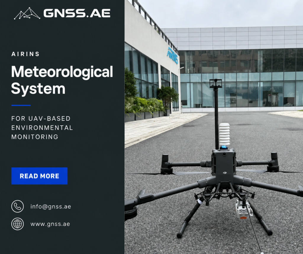
A nearby weather station may offer a useful regional reference, but local conditions can be different. Buildings redirect airflow, heated surfaces create convection and wind speed changes with height. The AIRINS Meteorological System was developed to collect these measurements where an inspection is taking place, either from a DJI Matrice 400 in flight or from a fixed position on the ground.
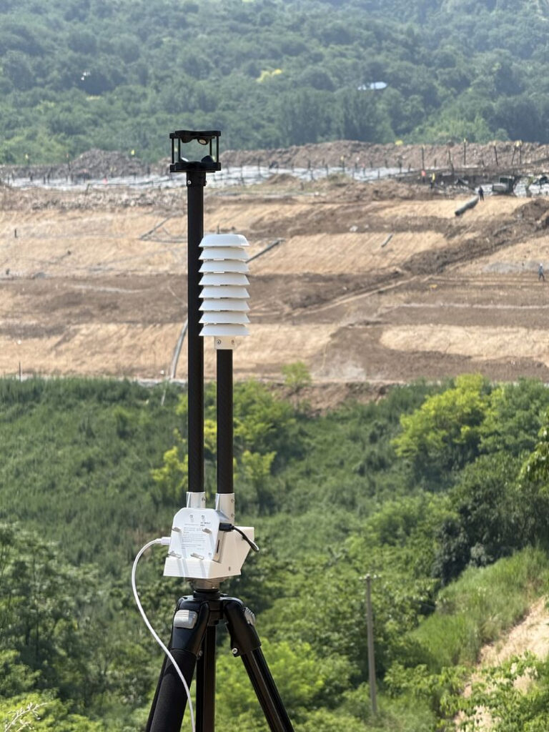
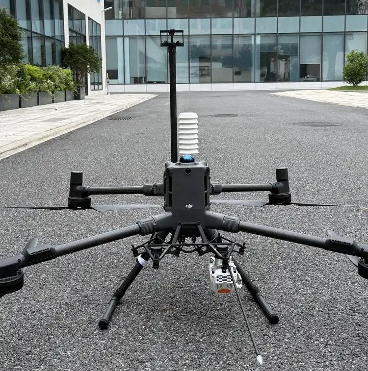
The AIRINS Meteorological System is a compact set of sensors and data-processing components designed for high-precision atmospheric measurements. Its primary aerial platform is the DJI Matrice 400, although the system can also operate as a stationary weather station when installed on a tripod.
It measures:
An integrated GNSS receiver connects every reading with its location and measurement time. During an aerial mission, the system also records the aircraft’s position, attitude and motion, producing a detailed account of both the atmosphere and the movement of the measurement platform.
The system can be flown as a standalone payload or used alongside AIRINS gas-detection equipment such as MetScan and Sniffer4D. This combined configuration is especially useful when an operator needs to relate a detected gas concentration to the wind field responsible for transporting it.
Fixed weather stations remain essential for long-term monitoring, forecasting and regional records. Their limitation appears when a project needs to describe the atmosphere at a specific height or around a particular structure.
Consider an inspection at a natural gas facility. The nearest weather station may report a steady north-westerly wind, while pipes, tanks and buildings create small areas of recirculating or turbulent air inside the site. A methane plume can bend around a structure, rise above it or become trapped in a sheltered area. Measurements taken several kilometers away cannot fully describe these effects.
Height introduces another variable. Wind close to the ground is slowed by friction and obstacles. Above the structures, it can be faster and more consistent. Temperature may also change with altitude, affecting the way air mixes. A drone carrying meteorological sensors can fly repeated profiles or follow the same route as a gas-detection payload, collecting atmospheric data within the survey volume rather than relying only on a distant reference.
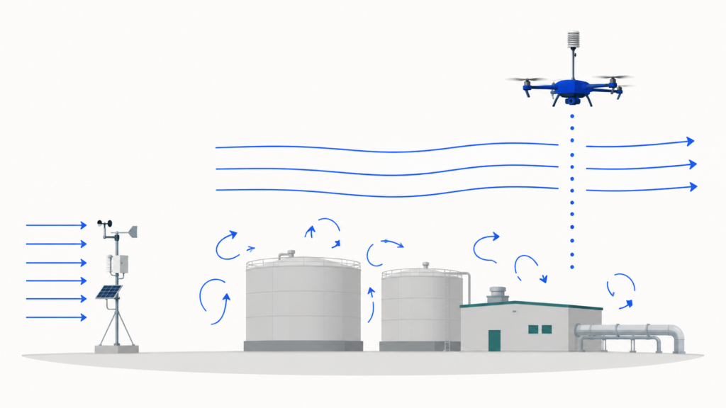
This does not make the fixed station redundant. Ground and aerial measurements can be used together: one provides continuous background conditions, while the other captures the local and vertical variations relevant to the mission.
Collecting reliable wind data from a multirotor aircraft presents an obvious engineering problem. The platform is moving, changing direction and producing its own airflow through the propellers.
AIRINS addresses this partly through the physical position of the sensor. The wind head sits on a mast 57 cm above the Matrice 400 rotor plane, where it is exposed to cleaner airflow and much less propeller wash than a sensor mounted close to the aircraft body.
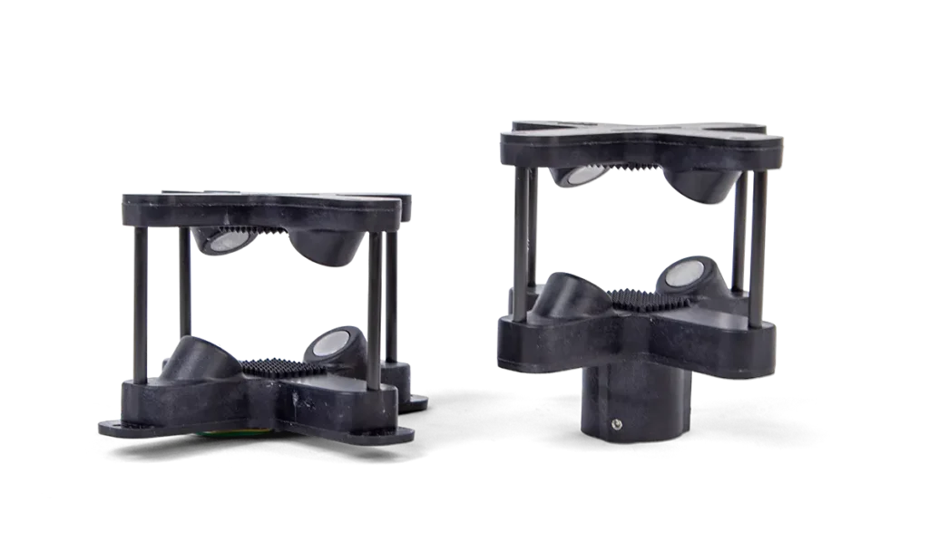
Wind is measured with a LI-COR TriSonica Mini three-dimensional ultrasonic anemometer. Instead of cups or other rotating parts, the instrument sends ultrasonic signals between several transducers. Moving air changes the time required for the signals to travel in different directions. From these differences, the sensor calculates three wind components: two horizontal components and one vertical component.
The anemometer itself can measure wind speeds from 0 to 50 m/s, with a resolution of 0.01 m/s. Its stated accuracy is ±0.2 m/s at speeds up to 10 m/s and ±2% from 11 to 30 m/s.
Orientation must also be considered. A north-facing stationary sensor has a stable reference, whereas a drone can turn several times during one flight. The AIRINS onboard algorithm accounts for aircraft heading and outputs the horizontal wind angle together with north and east wind components. Aircraft attitude, position and movement are stored with the meteorological readings for post-flight analysis.
The elevated mast and compensation algorithms substantially reduce two major sources of error, but mission planning still matters. Abrupt manoeuvres, rapid acceleration and flight close to large structures can produce highly disturbed airflow. Steady flight segments and repeatable routes generally provide more interpretable data.
Temperature and humidity are measured with a Vaisala HMP110 probe. The component covers a humidity range of 0–100% RH and offers accuracy of ±1.5% RH across most of that range under moderate temperatures. Its temperature measurement range extends from −40°C to +80°C, with accuracy reaching ±0.1°C within the central part of the range.
Installing a high-quality probe on a drone is only part of the solution. Direct sunlight can heat the sensor housing and raise the measured temperature above that of the surrounding air. A slowly ventilated probe can also lag behind real atmospheric changes as the aircraft moves between different heights or areas.
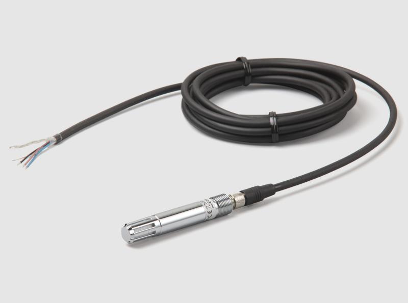
AIRINS places the temperature and humidity probe inside a custom radiation shield with an active fan. The shield limits direct solar heating, while the fan draws ambient air across the sensor. This arrangement supports a faster response and makes measurements taken at different points along the flight path easier to compare.
The AIRINS Meteorological System records data at 10 Hz, producing ten sets of measurements per second. Each record can include meteorological variables as well as GNSS position, time, aircraft attitude and motion.
Live readings and system settings are available in the DJI Pilot 2 app through DJI Payload SDK integration. The complete dataset is saved to an SD card in CSV format, allowing it to be reviewed in analysis, GIS or scientific software after the mission.
The combination of measurement frequency and georeferencing is particularly useful for mobile surveys. Instead of receiving a single average wind value for the entire site, analysts can compare atmospheric conditions at different positions and heights. They can also align changes in wind with gas-concentration peaks collected during the same inspection.
High-frequency data still requires careful processing. Short fluctuations may represent genuine turbulence, aircraft movement or disturbed flow near an obstacle. Filtering, quality checks and comparison between repeated passes help distinguish consistent site conditions from temporary effects.
The same system supports two distinct measurement methods.
Mounted on a Matrice 400, it can collect horizontal transects, vertical profiles and measurements over areas that would be difficult to instrument from the ground. A vertical flight can show how wind speed, direction and temperature change with altitude. A route across an industrial site can reveal how structures affect the local wind field.
In stationary mode, the system is installed on a tripod and continues to log wind speed, wind direction, temperature, humidity and pressure at 10 Hz. Its built-in GNSS receiver provides positioning and time synchronization without relying on the drone.
Stationary operation is useful when a gas survey needs a consistent wind reference throughout the mission. It can also support controlled-release tests, methane flux studies and emission-rate calculations where the wind must be measured continuously at a known location.
The choice depends on the question being investigated. A fixed position is suitable for monitoring change over time at one point. A drone is better suited to examining spatial and vertical differences. Some projects may benefit from both.
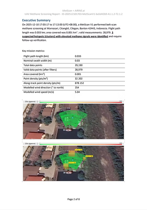
Meteorological data becomes especially valuable when paired with the AIRINS methane-detection workflow.
MetScan can remotely screen infrastructure and identify elevated methane along a pipeline or inside a facility. Sniffer4D measures gas concentration at the aircraft’s location and builds a georeferenced distribution of readings. These systems show where methane was detected during the survey.
Wind data helps explain how it reached that location. If repeated methane peaks appear downwind of a particular group of components, the combined dataset gives the inspection team a stronger basis for selecting the area that requires close-range verification.
The same information contributes to methane quantification. Estimating an emission rate requires more than detecting a high concentration. The calculation must consider how much methane is being transported through the measured plume, making local wind speed and direction central inputs. Poor or unrepresentative wind measurements can introduce substantial uncertainty even when the gas sensor performs well.
This is relevant to oil and gas facilities, pipelines, landfills and wastewater treatment plants. It also supports controlled-release experiments, where a known methane flow is used to validate detection and quantification methods.
The system’s use is not limited to methane. Three-dimensional wind measurements can support air-pollution dispersion studies, research into near-ground atmospheric conditions and the investigation of airflow around structures.
Emergency teams may use local wind information when assessing the likely movement of a hazardous release, provided that measurements can be collected without exposing personnel or operating the aircraft outside safe limits. Vertical profiles can add useful context to atmospheric research, while repeated surveys can document how conditions change by time of day or season.
For these applications, the strength of an aerial system lies in measurement flexibility. Sensors can be taken to the height and location relevant to the problem, rather than requiring the entire analysis to be based on conditions at one ground station.
Gas concentration maps answer an important question: where was an elevated reading observed? The AIRINS Meteorological System adds the atmospheric information needed to interpret that observation—how the air was moving, what conditions surrounded the measurement and how those conditions changed across the site.
With high-frequency wind, temperature, humidity, pressure and GNSS data, the system turns the DJI Matrice 400 into a mobile meteorological platform. Its stationary mode provides an additional option for continuous local wind monitoring.
For methane inspection and quantification, this context can help teams move from detecting an anomaly to investigating its likely origin and scale. For environmental research, it opens access to atmospheric measurements at positions and heights that are difficult to cover with fixed instruments alone.
The AIRINS Meteorological System is a UAV-compatible instrument for measuring local wind and atmospheric conditions. It can be mounted on a DJI Matrice 400 or installed on a tripod as a stationary weather station.
The system records three-dimensional wind speed, wind direction, air temperature, relative humidity and atmospheric pressure. Its GNSS receiver adds accurate position and time information to every measurement.
The system uses a LI-COR TriSonica Mini ultrasonic anemometer with a wind-speed resolution of 0.01 m/s and accuracy of ±0.2 m/s at speeds up to 10 m/s. Its Vaisala HMP110 probe provides humidity accuracy of up to ±1.5% RH and temperature accuracy of up to ±0.1°C under specified conditions. Actual field performance also depends on installation, calibration, flight behaviour and environmental conditions.
The current aerial configuration is designed for the DJI Matrice 400. It uses a quick-mount bracket and DJI Payload SDK integration, allowing operators to view live measurements and adjust settings through the DJI Pilot 2 app.
Yes. The system can be placed on a tripod and used as a stationary meteorological station. In this mode, it continues to record wind speed, wind direction, temperature, humidity and pressure at 10 Hz, with built-in GNSS for positioning and time synchronization.
A three-dimensional ultrasonic anemometer is positioned 57 cm above the Matrice 400 rotor plane to reduce propeller-wash interference. The system also uses aircraft heading and motion data to calculate horizontal wind direction and its north and east components.
Yes. It can operate alongside MetScan, Sniffer4D Nano 2 Plus and other Matrice 400 payloads. Combining meteorological and gas-concentration data helps operators analyze plume movement, identify likely emission sources and support methane flux or emission-rate calculations.