For many geophysical projects, the main difficulty is not collecting magnetic data but actually getting where you want to do the survey.
Steep slopes, dense vegetation, wetlands, remote corridors, and protected sites often make traditional ground magnetometry slow and expensive. Conventional airborne surveys can solve some of these problems, but they usually require a larger aircraft, higher operating costs, and more complex logistics.
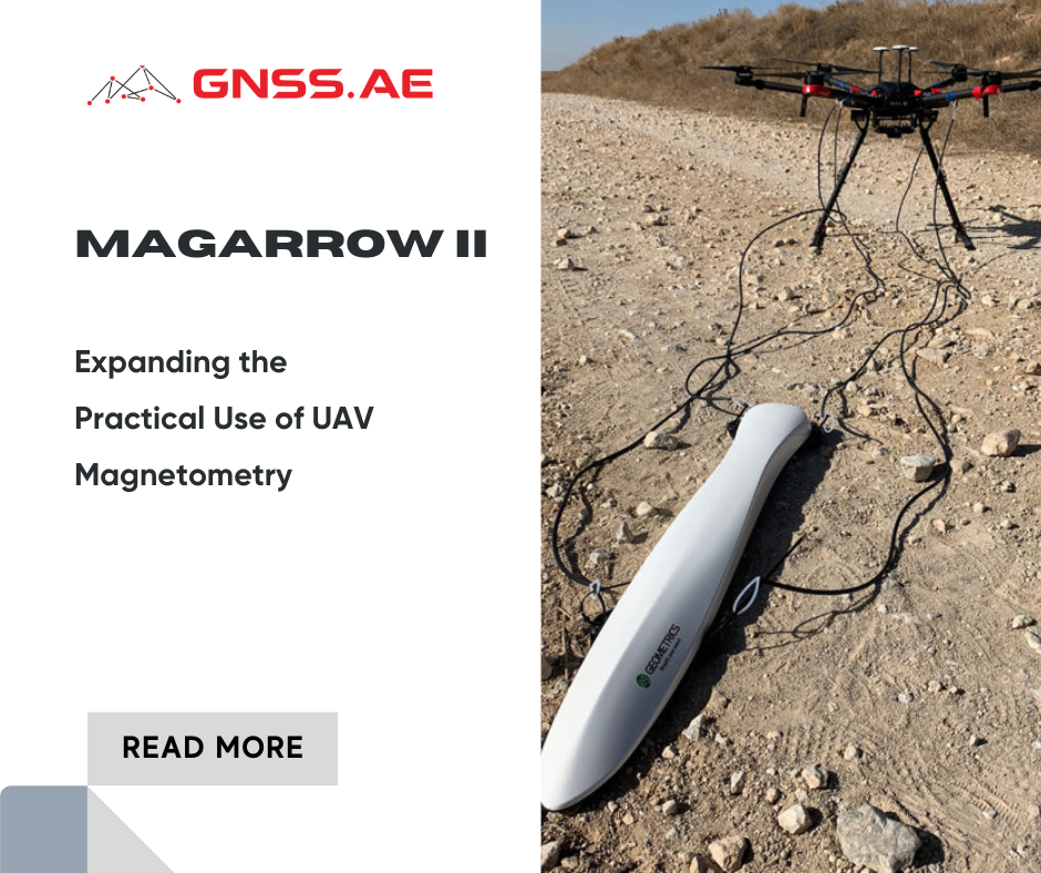
MagArrow II is a lightweight UAV magnetometer designed to be suspended below an enterprise drone and flown along pre-planned survey lines. Instead of carrying a full-size airborne system, the operator can deploy a compact sensor from a standard UAV platform and collect high-resolution magnetic data over difficult terrain.
Unlike many earlier UAV magnetometers, MagArrow II is not simply a smaller version of a traditional system. The sensor was designed specifically for drone operations: lightweight, self-contained, and able to work independently of the aircraft.
Traditional ground surveys often struggle with access and speed. Maneuvering a magnetometer through dense vegetation or across uneven ground can take days—sometimes the area is simply unreachable safely.
With MagArrow II suspended below the drone, the aircraft can follow stable survey lines at a constant height above the ground. Large areas can be covered faster and with much more consistent spacing than in a manual survey.
According to the manufacturer, MagArrow II can survey inaccessible terrain up to ten times faster than a typical ground magnetic survey. This is especially important for:

The most important change in MagArrow II compared with earlier UAV magnetic systems is that almost everything is built into the payload itself.
The unit contains:
Because of this, no data cable or power connection to the drone is required. The payload can be attached to different UAV platforms without major modification.
The system weighs only 1.2 kg, which allows it to be carried by many common enterprise drones while still leaving enough endurance for practical survey missions.
Key Specification | MagArrow II |
Weight | 1.2 kg |
Length | 1 m |
Sample Rate | 1000 Hz |
Battery Life | Up to 2 hours |
Operating Speed | Up to 10 m/s |
GPS / IMU | Integrated |
Data Download | Wireless via Wi‑Fi |
UAV Connection | Not required |
The 1000 Hz sample rate is one of the most important features. At flight speeds of up to 10 m/s, the system can still collect a magnetic sample approximately every centimeter.

One of the classic challenges with magnetometers is that the way the sensor is oriented can really impact the readings. Some sensors can lose their accuracy or even hit “dead zones” when they’re turned in certain directions.
MagArrow II addresses this problem using two miniature MFAM magnetic sensors mounted inside the payload.
These sensors are arranged so that if one gets into a tricky position, the other remains in its optimal position. Their signals are combined into a single magnetic reading.
As a result, the system continues to produce stable measurements even when the UAV changes direction, turns between survey lines, or operates in areas where a traditional sensor would experience drop-outs.
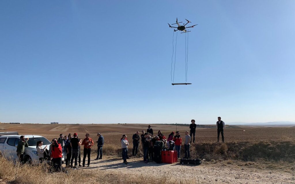
MagArrow II is not tied to a specific UAV platform. Because the sensor has its own battery, GNSS receiver, storage, and Wi‑Fi connection, it can be used with almost any professional drone capable of carrying approximately 1–1.5 kg.
To reduce magnetic interference from the UAV, Geometrics recommends suspending the sensor 2–3 m below the drone on a non-magnetic tether. For this reason, larger enterprise UAVs are usually the best choice.
Recommended UAV | Recommended Use |
DJI Matrice 600 Pro | Most common platform. Can carry the sensor on a full 3 m tether. |
More portable, but often requires landing gear extensions or a shorter tether. | |
Only for lightweight or short missions | |
Heavy-lift or multi-sensor projects | |
Better suited to camera and Dock operations | |
Large-area magnetic surveys, difficult terrain, long missions |
In most cases, the DJI Matrice 600 Pro is the preferred option because it provides the best balance between payload, stability, and sensor clearance.
The real strength of MagArrow II is seen in projects where access is difficult, dangerous, or expensive.

One of the more interesting uses of UAV magnetometry is geothermal exploration.
Many geothermal systems don’t show any visible signs on the surface—there are no hot springs, steam vents, or altered ground to indicate their presence. Instead, the real clues lie beneath the surface, hidden in the fault structures that guide the flow of hot fluids.
In these projects, MagArrow II can help identify subtle magnetic anomalies associated with hydrothermal alteration. When geothermal fluids alter magnetic minerals such as magnetite, the rocks may become less magnetic and create a localized low magnetic anomaly.
Geologists typically search for circular or semi-circular low magnetic anomalies instead of long, linear features, as these can suggest areas where hydrothermal fluids have changed the surrounding rocks.
Compared to standard ground surveys, UAV magnetometry is a significant time-saver, with a typical ground crew able to gather 15–20 line km per day, while a UAV magnetic survey can often exceed 100 line km in the same period.
For regional geological mapping and mineral exploration, UAV magnetometry allows survey teams to cover large areas quickly while maintaining high-resolution data.
Flying at lower altitudes can uncover subtle magnetic anomalies that might be overlooked in higher-altitude manned surveys. This is especially useful in mountainous terrain, desert environments, or remote exploration blocks.
One of the most practical uses of MagArrow II is the detection of unexploded ordnance and buried metallic objects.
Large UXO sites are often too dangerous or too large for a purely ground-based survey. A UAV can screen the entire area first, identify the strongest anomalies, and then guide a detailed follow-up investigation.
For archaeological projects, the ability to detect buried structures without disturbing the ground is a major advantage.
The sensor can reveal foundations, roads, trenches, and former building outlines beneath vegetation or shallow soil. Since the UAV never touches the site itself, the survey can be completed with minimal disturbance.
MagArrow II is also useful for locating buried pipelines, abandoned wells, storage tanks, and other hidden infrastructure.
In environmental remediation projects, this can significantly reduce the amount of time required to locate legacy infrastructure before excavation begins
Application | Why MagArrow II Is Useful |
UXO Detection | Rapid coverage of dangerous areas without sending personnel into the field |
Buried Pipelines | Detection of long linear metallic objects |
Archaeology | Identification of buried walls, foundations, and structures without excavation |
Environmental Surveys | Locating abandoned wells, tanks, and buried infrastructure |
Geology | Mapping magnetic variations across large areas |
Mission planning is one of the most important parts of a UAV magnetic survey.
Since the sensor is flown below the drone, the aircraft needs to fly in a stable altitude and avoid high slopes, vegetated areas and obstacles. High-resolution elevation models are often used during planning so the UAV can follow the terrain more accurately.
In mountainous areas, operators usually balance two competing requirements: flying low enough to improve magnetic resolution, but high enough to maintain a safe distance from the ground.
Typical survey altitudes are 10 to 50m, although lower flights may be employed depending on the terrain.
After the field survey, the raw magnetic data is usually processed using geophysical software such as Oasis montaj.
The standard workflow often includes:
These processed datasets make it easier to interpret faults, buried structures, and other magnetic anomalies that may not be visible in the raw data.
MagArrow II represents a practical shift in how magnetic surveys can be performed.
Instead of relying only on ground crews or expensive manned airborne operations, survey teams can now collect high-resolution magnetic data using a standard enterprise UAV.
The main benefit is not simply faster surveying. It is the ability to work in places that were previously difficult, unsafe, or too expensive to investigate.
For geology, UXO, archaeology, environmental projects, and buried infrastructure mapping, MagArrow II provides a more flexible way to perform magnetic surveys while maintaining the data quality expected from a professional geophysical workflow.