From its early beginnings as the Global Positioning System (GPS) to today’s advanced multi-constellation GNSS receivers, satellite-based positioning has transformed the way surveyors collect spatial data. Despite continuous technological progress, GNSS surveying still faces inherent challenges and errors that can impact accuracy and productivity. Understanding these challenges and how modern GNSS technology mitigates them is essential for successful field operations.
In GNSS surveying, maintaining a constant and unobstructed connection between ground-based receivers and satellites in space is critical. Even the most experienced surveyor will encounter environmental and operational conditions beyond their control. For this reason, the choice of GNSS receiver plays a decisive role in ensuring reliable performance and efficient project execution.
By recognizing common GNSS issues and understanding how modern sensors handle them, geospatial professionals across all industries can overcome limitations both in the field and during post-processing.
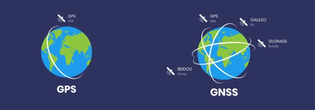
The foundation of modern GNSS surveying lies in the Global Positioning System (GPS), developed by the United States Department of Defense and first released in 1978. GPS was designed as a global navigation resource for both military and civilian applications.
The original system relied on a constellation of 24 satellites orbiting the Earth, each acting as a precise reference point. GPS receivers on the ground used signals from these satellites to compute their position.
Today, GPS is complemented by additional satellite constellations, including GLONASS, Galileo, BeiDou, and others. Together, these systems form what is collectively known as Global Navigation Satellite Systems (GNSS). The availability of multiple constellations significantly increases the number of satellites in orbit, improving signal availability, reliability, and positioning performance worldwide.
GNSS receivers operate by listening to specially coded signals transmitted by each satellite. By measuring the time it takes for a signal to travel from the satellite to the receiver’s antenna, the receiver can calculate the distance to that satellite. This distance is determined by multiplying the signal’s travel time by the speed of light.
A GNSS receiver performs this calculation simultaneously with multiple satellites. When signals from at least four satellites are available, the receiver can accurately determine its three-dimensional position anywhere on the Earth’s surface. The quality of this solution, however, depends heavily on signal integrity and environmental conditions.
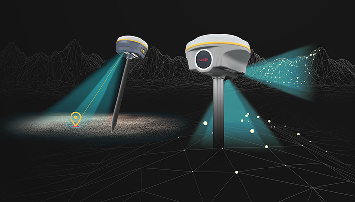
GNSS accuracy is highly dependent on a clear line of sight between the receiver and satellites. When this view is blocked or partially obstructed, positioning errors can occur, even when tracking a large number of satellites.
One of the most common sources of error is multipath, which occurs when satellite signals reflect off nearby objects such as buildings, trees, or other structures before reaching the receiver. Instead of traveling directly from the satellite, these reflected signals distort distance calculations and degrade positioning accuracy. Multipath is particularly prevalent in urban environments and near large obstructions.
While surveyors can sometimes minimize multipath through careful positioning and field techniques, other GNSS errors are completely outside their control. These include atmospheric disturbances, satellite-related errors, and hardware-related issues such as receiver malfunctions.
In today’s surveying workflows, the way a GNSS receiver detects, filters, and compensates for errors makes the greatest difference to daily productivity. Advances in receiver design, signal processing, and multi-constellation tracking have dramatically expanded the environments in which GNSS can be used effectively.
Modern GNSS technology allows surveyors to work in conditions that were nearly impossible a decade ago. Surveying in dense urban canyons, operating closer to buildings, and collecting data beneath thicker canopy cover are now achievable without sacrificing accuracy. In many cases, surveyors no longer need to switch between GNSS rovers and total stations, resulting in substantial time savings and more streamlined workflows.
Surveyors do not have the luxury of choosing where projects are located or under what conditions data must be collected. Whether working in challenging urban environments, remote areas, or obstructed landscapes, the expectation remains the same: deliver accurate results efficiently.
Modern GNSS receivers provide the tools necessary to meet these demands. By overcoming traditional limitations and adapting to real-world conditions, today’s GNSS technology empowers geospatial professionals to complete projects anywhere, under virtually any conditions, without compromising precision or reliability.
At GNSS.AE, we offer a range of GNSS-enabled devices trusted by organizations across Middle East and Africa region. Contact our team to find the GNSS solution tailored for your needs.