Oil spills are among the most devastating environmental emergencies—posing severe threats to marine ecosystems, coastal communities, and global economies. According to the European Space Agency, more than 4.5 million tons of oil are spilled into the world’s oceans each year, with nearly 45% resulting from operational discharges from ships. Rapid detection and containment are critical to minimizing long-term environmental and economic damage.
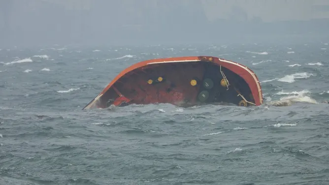
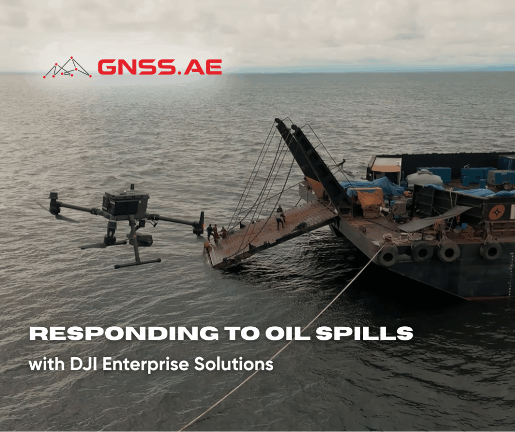
On July 25, 2024, the Motor Tanker Terranova capsized off the coast of Bataan, Philippines, after being struck by Typhoon Carina while en route to anchorage. The vessel, carrying 1.4 million liters of industrial fuel, began listing to the starboard side before sinking approximately three nautical miles from shore.
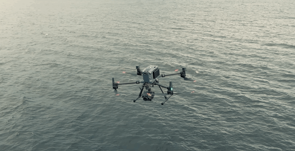
The incident triggered a large-scale emergency response. Harbor Star Shipping Services, tasked with the containment and cleanup operation, faced the dual challenge of preventing widespread contamination and protecting coastal residents from hazardous fumes. To meet these challenges, the team deployed DJI Enterprise drones—a crucial decision that transformed the speed and precision of their operations.
Every hour, DJI Enterprise drones were launched to provide real-time aerial surveillance, thermal imaging, and directional mapping of the oil slick. These insights enabled tugboats to adjust their positions dynamically and intercept the spreading oil before it reached the shoreline.
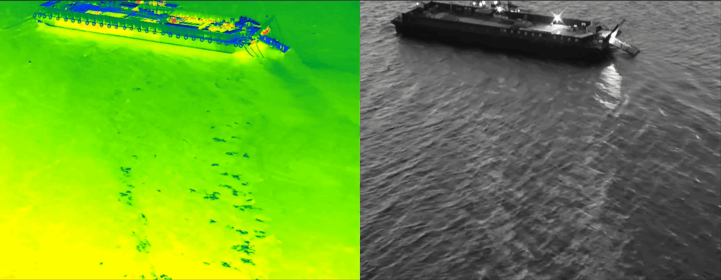
Oil spill behavior is highly unpredictable, influenced by shifting currents and winds. While the human eye can only detect visible sheens, drone-mounted thermal cameras reveal invisible, thicker oil concentrations beneath the surface—allowing teams to target high-density areas that would otherwise be overlooked.
As explained by the company representative, “Without drones, we can’t capture everything. The oil changes direction quickly, and what you can’t see is often the most dangerous. The drone gives us eyes beyond what’s visible.”
The recovery operation focused on securing leaks from 24 pressure valves, of which only four were initially stabilized. With the aid of drone guidance, the team worked through day and night to correct remaining leaks and implement permanent sealing solutions.
Two tugboats were tasked with catching surface oil, while a standby vessel applied chemical dispersants to break down slicks. A skimmer boat followed to recover the emulsified oil. The coordinated response—directed through hourly drone observations—ensured minimal oil reached the coastline, preventing harm to marine life and nearby communities.
In environmental emergencies like this, the combination of multispectral and thermal imaging provides unmatched situational awareness. Multispectral cameras capture reflected light across visible and near-infrared (VNIR) wavelengths, allowing responders to detect oil even when it’s invisible to the human eye. As explored in our earlier article, Detection of Oil Spills Using Multispectral Cameras: Advances in Remote Sensing Technology, these sensors play a vital role in analyzing oil-water contrast, estimating layer thickness, and classifying oil types based on their spectral signatures.
By integrating both imaging techniques, responders gain a multi-layered understanding of the spill: tracking spread, identifying contamination zones, and quantifying surface oil thickness.
Unmanned Aerial Vehicles (UAVs) equipped with advanced sensors deliver several advantages over traditional response methods:
In the case of the Terranova spill, DJI Enterprise drones not only accelerated decision-making but also enabled safer working conditions by reducing human exposure to toxic environments.
The Terranova operation underscores a critical truth: drone technology has become indispensable in modern environmental crisis management. By combining real-time intelligence, precision imaging, and rapid deployment, drones empower responders to act faster, safer, and with greater accuracy than ever before.
As extreme weather events and maritime incidents become more frequent, adopting UAV-based remote sensing systems is no longer optional—it is essential for safeguarding our oceans and coastlines.
Contact GNSS.AE to learn more about DJI Enterprise drone systems and discover how your organization can harness advanced UAV intelligence to transform project planning, data analysis and operational efficiency.