The debate between drone surveys and manual surveys has become increasingly relevant in modern surveying and mapping. As demand for faster, more accurate, and more efficient data acquisition grows, traditional manual methods are encountering significant challenges. These include time-consuming processes, safety risks for workers, and limited accessibility to certain areas.
To address these issues, drone surveys have emerged as an innovative solution. Equipped with advanced technology, drones can overcome these limitations while delivering high-quality data. In this article we explore five key differences between drone surveys and manual surveys to help you determine the most suitable method for your project.
Drones significantly accelerate data collection. For instance, the DJI Matrice 400 equipped with the DJI Zenmuse P1 camera offers a flight time of up to 59 minutes per mission and can cover as much as 7.5 km² per day. This translates to data acquisition speeds up to 60% faster than traditional surveying.
Comparison of Survey Time and Area Coverage:
| Method | Survey Time | Area Covered | Efficiency |
|---|---|---|---|
| Manual Survey | 10–14 days | ± 2 km² | Slow process, labor-intensive |
| DJI M400 + DJI Zenmuse P1 | 1 day | 7.5 km² | 60% faster, covers wider areas efficiently |

Manual surveying was once regarded as the gold standard for accuracy. However, with technologies such as the DJI M400 paired with DJI Zenmuse L2 LiDAR sensor, drone surveys now rival—and often surpass—traditional methods.
By integrating LiDAR, advanced IMUs, and RTK positioning systems, drone surveys achieve vertical accuracy of up to 4 cm and horizontal accuracy of 5 cm. These results are consistent across different environments and remain reliable in both real-time and post-processing workflows.
Comparison of Accuracy:
| Method | Vertical Accuracy | Horizontal Accuracy | Real-Time Accuracy | Post-Process Accuracy |
|---|---|---|---|---|
| Manual Survey | 2–5 cm (operator/tool dependent) | 2–5 cm | Depends on instruments used | Depends on re-registration |
| DJI M400 + DJI Zenmuse L2 | Up to 4 cm | Up to 5 cm | Yaw: 0.2°, Pitch/Roll: 0.05° | Yaw: 0.05°, Pitch/Roll: 0.025° |
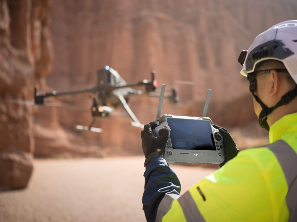
Safety is a major advantage of drone surveys, particularly in hazardous environments such as mountainous terrain or active construction zones. Manual methods expose workers to significant risks, whereas drones allow data collection from a safe distance.
DJI Matrice 400 O4 Enterprise Enhanced Video Transmission System enables real-time monitoring at distances of up to 20 km (CE) and 40 km (FCC). This eliminates the need for personnel to physically enter dangerous sites and reduces the risk of accidents. Additionally, drone surveys minimize disruptions by avoiding the need to close roads, railways, or other operational areas.
While drones require higher initial investment, they quickly prove cost-effective by reducing manpower, minimizing risks, and accelerating survey times. DJI Matrice 400, with its extended flight endurance and large coverage area, requires only a small team—typically just one operator and a data technician.
Cost Comparison:
| Method | Manpower Needs | Survey Time | Area Covered/Day | Cost Efficiency |
|---|---|---|---|---|
| Manual Survey | Large team required | Days/weeks | ±1–2 km² | High (labor and time costs) |
| Drone Survey (DJI M400) | 1–2 operators only | Hours | Up to 7.5 km² | Highly efficient, economical in the long term |
With after-sales services and support from providers such as GNSS.AE, drone solutions maximize return on investment, making them a practical choice for large-scale operations.
Drones excel in environments that are challenging—or even impossible—for manual surveying. The DJI M400’s Real-Time Terrain Follow feature ensures the aircraft maintains stable altitude relative to ground contours, preserving consistent Ground Sample Distance (GSD) even over hilly terrain.
With LiDAR sensors, drones can also map areas with dense vegetation, swamps, or steep slopes, capturing highly detailed topographic data. This capability allows surveys to be conducted with greater precision and without physical risk to field crews.
The choice between manual and drone surveying ultimately depends on project requirements. However, when efficiency, accuracy, safety, and flexibility are priorities, drone surveys clearly deliver substantial advantages. By leveraging advanced platforms like the DJI M400, professionals can achieve faster, safer, and more cost-effective results—redefining the future of surveying and mapping.
At GNSS.AE, we provide cutting-edge drone surveying solutions tailored to the needs of surveying, construction, and mapping professionals across the Middle East and Africa. Our team ensures that clients benefit from the latest technologies, expert support, and reliable after-sales services to maximize the value of their investment.