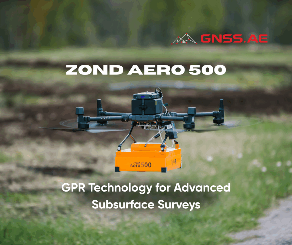
Ground Penetrating Radar has transformed subsurface exploration across multiple industries, enabling professionals to detect underground structures, utilities, and geological features with unprecedented accuracy. The Zond Aero 500 represents a significant advancement in GPR technology, offering flexible deployment options and exceptional performance for both aerial and ground-based applications.
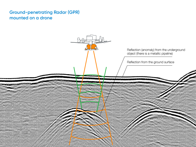
Ground Penetrating Radar operates by transmitting electromagnetic energy into the subsurface environment. The GPR transmitter emits radar pulses that travel through the ground until they encounter buried objects or boundaries between materials with different dielectric permittivities—a fundamental property that determines how electromagnetic waves propagate through various substances. When these energy pulses encounter such interfaces, they reflect back to the GPR’s receiving antenna.
The system’s electronics continuously record and analyze variations in these return signals, creating a detailed picture of subsurface conditions. This process allows operators to identify buried utilities, geological formations, voids, and other features that would otherwise remain hidden beneath the surface.
Not all GPR systems are created equal, and this diversity serves a crucial purpose in meeting varied survey requirements. The fundamental distinction lies in antenna frequency selection, which directly impacts both penetration depth and target resolution capabilities.
Low-frequency GPR systems excel in deep penetration applications, capable of detecting large objects at significant depths below the surface. However, this enhanced depth capability comes with a trade-off in resolution, making these systems ideal for geological surveys and large-scale infrastructure mapping. Low-frequency antennas typically feature larger, unshielded designs to maximize their penetration capabilities.
High-frequency GPR systems prioritize resolution over depth, delivering exceptional detail for smaller targets in shallow subsurface investigations. These systems utilize compact, shielded antenna designs that minimize environmental interference and noise, making them perfect for utility mapping, archaeological work, and precise structural assessments.
The Zond Aero 500, operating at 500 MHz, represents an optimal middle ground in this frequency spectrum, balancing penetration depth with target resolution to serve the widest range of survey applications.
The Zond Aero 500 operates at a center frequency of 500 MHz, delivering optimal penetration capabilities for mid-depth surveys. In terrestrial applications, operators can achieve penetration depths of up to 4 meters in typical soil conditions, while drone-mounted surveys reach effective depths of 2 meters. This frequency range strikes an ideal balance between depth penetration and target resolution.
The system’s high-resolution imaging capabilities are powered by a bandwidth spanning 200-900 MHz and an impressive sample rate of 25,600 samples per second. This technical configuration enables the detection of objects as small as 10 cm when operating from recommended flight altitudes, making it particularly effective for precision applications.
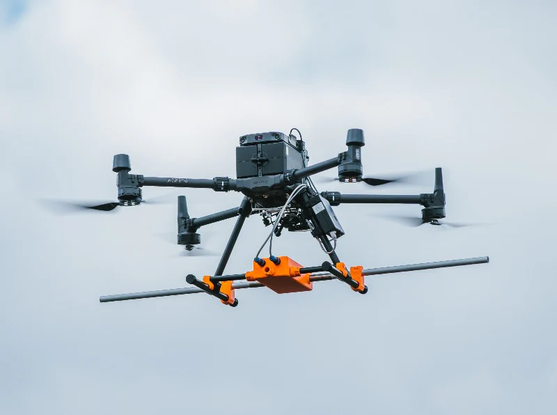
One of the most compelling aspects of the Zond Aero 500 is its dual-configuration capability. The system seamlessly transitions between airborne and terrestrial modes, adapting to diverse survey requirements and environmental constraints. At just 2.1 kg in its airborne configuration, the unit maintains excellent portability without compromising data quality or flight endurance.
The system incorporates robust data management features, storing information in Geophysical SEGY format for seamless integration with industry-standard processing software. This ensures that collected data maintains its integrity and remains accessible for comprehensive post-survey analysis.
Enhanced Survey Efficiency: The Zond Aero 500 processes data at 50 scans per second, significantly reducing field time while maintaining data quality standards. This rapid acquisition rate allows survey teams to cover larger areas more effectively.
Extended Accessibility: Drone deployment capabilities enable surveys in hazardous, remote, or otherwise inaccessible locations, expanding the range of feasible projects and improving worker safety.
Advanced Data Control: The system features sophisticated digital filtering, adjustable gain settings, and customizable time range selection, allowing operators to optimize data collection parameters for specific survey objectives.
Environmental Durability: Ground-based operations benefit from IP68-rated protection, ensuring reliable performance across challenging environmental conditions.
The Zond Aero 500 excels in utility mapping, geological surveys, archaeological investigations, and structural assessments. Its balanced approach to depth penetration and target resolution makes it particularly valuable for urban infrastructure projects, where precise identification of underground utilities is critical.
The system’s versatility extends to rural and remote area surveys, where the combination of drone capability and ground-based precision provides comprehensive subsurface mapping solutions. Whether investigating potential cavities, mapping geological formations, or locating buried infrastructure, the Zond Aero 500 delivers consistent, reliable results.
For organizations requiring adaptable, high-performance GPR solutions, the Zond Aero 500 offers the technical capabilities and operational flexibility necessary for successful subsurface investigations. Contact GNSS.ae to explore how this advanced GPR system can enhance your survey capabilities.