JOUAV CW Series Aeromagnetic Surveying System

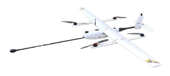
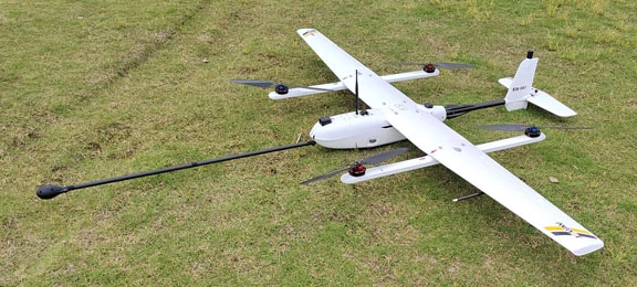
The CW series Aeromagnetic Surveying System takes the lead in introducing the latest generation of high-precision micro-rubidium magnetometer, which integrates a high-precision fluxgate tri-axial magnetometer, GPS, laser altimeter, 9-axis attitude sensor, and barometric altimeter. Using self-developed patented fixed-wing aeromagnetic compensation technology, it eliminates the interference caused by the magnetometer probe during the maneuvering flight of the aircraft, obtaining high-precision magnetic total field and magnetic vector field data. In addition to the high-precision fluxgate magnetometer, the main total field magnetic sensor of this series of unmanned aerial magnetic equipment is a high-precision optically pumped magnetometer, which meets the requirements of aviation magnetic survey technical specifications.

Categories:

Inquire Now

    By submitting this message, you agree with the privacy policy and the processing of personal data.


    * - required fields

    Features

    High Quality
    High Quality

    The JOUAV UAV platform has a high accuracy of movement and meets the quality requirements of the aeromagnetic survey specifications.

    High Precision
    High Precision

    JOUAV UAS can be flown with gentle terrain undulations, and high precision and high-resolution aerial magnetic survey data can be obtained in areas with gentle terrain.

    Auto Flight Position Compensation
    Auto Flight Position Compensation

    The JOUAV aeromagnetic system has improved the flight control operating system and realized automatic maneuvering attitude flight compensation, which effectively reduces the magnetic interference of the UAV platform.

    Lightweight Design
    Lightweight Design

    The system equipment is much lighter, less costly, less risky, and more efficient than normal aerial magnetic equipment, making it very easy to carry out fieldwork.

    High Efficiency
    High Efficiency

    JOUAV drones can be used to complete a large area of fast aerial magnetic survey, and the work efficiency is greatly improved compared with traditional aerial magnetic detection.

    Wide Application Prospects
    Wide Application Prospects

    The large-scale, high-resolution, and high-precision aerial magnetic survey can provide a reliable basis for mineralization search and has a broad application prospect and promotion value.

    Technical Specifications

    Whole System
    Full load weight
    ≤0.7kg
    Airborne dynamic noise level
    ≤0.08nT
    Total power consumption
    ≤13W
    Optical-pumping Magnetometer
    Light pump magnetometer type
    Micro rubidium light pump magnetometer
    Light pump resolution
    0.0001nT
    Ground static noise level
    ≤0.01 nT
    Light pump range
    1000 nT – 100000 nT
    Gradient tolerance
    100 nT/cm
    Sensitivity
    ≤0.02nT/√Hz (0.1-100 Hz band, power spectrum)
    Light pump power consumption (operating state)
    ≤3W
    Fluxgate Magnetometer
    Measurement Range
    ±70μT
    Fluxgate output voltage
    ±10V
    Frequency domain noise
    ≤6pT rms/√Hz
    Linearity
    ≤0.01%FS
    Orthogonality
    ≤±0.2°
    Vector magnetometer power consumption
    ≤0.45W
    Laser Altimeter
    Laser altimeter range (at 90% reflectivity)
    ≤500m, accuracy 1m
    GPS Receiver
    Positioning accuracy
    ≤2m (in normal mode), ≤2CM (in GNSS RTK mode)
    Wireless Digital Transmission
    The power
    1000mw
    Synchronized Data Collector
    Data collector sampling rate
    1, 2, 5, 10, 20Hz
    Data collector ADC accuracy
    24 bits
    Highly accurate attitude measurement data collector
    ≤0.1°
    Data collector functions
    Capable of supporting upgrade into collecting two light pump magnetometer data to form aeromagnetic gradient measurement, high precision ADC sampler to collect fluxgate data, a record high precision attitude measurement IMU module, record GPS, laser altitude, barometric altitude, plane coordinate auto conversion data. Data collector with light pump and fluxgate real-time and aero-magnetic compensation function. Data storage capacity 64GB
    Aeromagnetic processing software features
    It has the functions of real-time aerial magnetic data return detection; automatic route planning and ground-like flight route planning based on a digital elevation model; optical pump and flux gate aerial magnetic data compensation calculation; aerial magnetic data pre-processing, including data display, line cutting, distortion removal, daily change correction, quality evaluation, and other functions.

    * All performance data in the foregoing pages are theoretical values obtained by JOUAV® internal laboratories through tests carried out under particular conditions. For more information on the specific testing conditions, refer to the aforementioned product details. Actual performance may vary owing to differences in individual product configuration, software versions, application conditions, and environmental factors. All data is subject to actual usage.

    Download brochure

      By submitting this message, you agree with the privacy policy and the processing of personal data.


      * - required fields

      Inquire price for JOUAV CW Series Aeromagnetic Surveying System