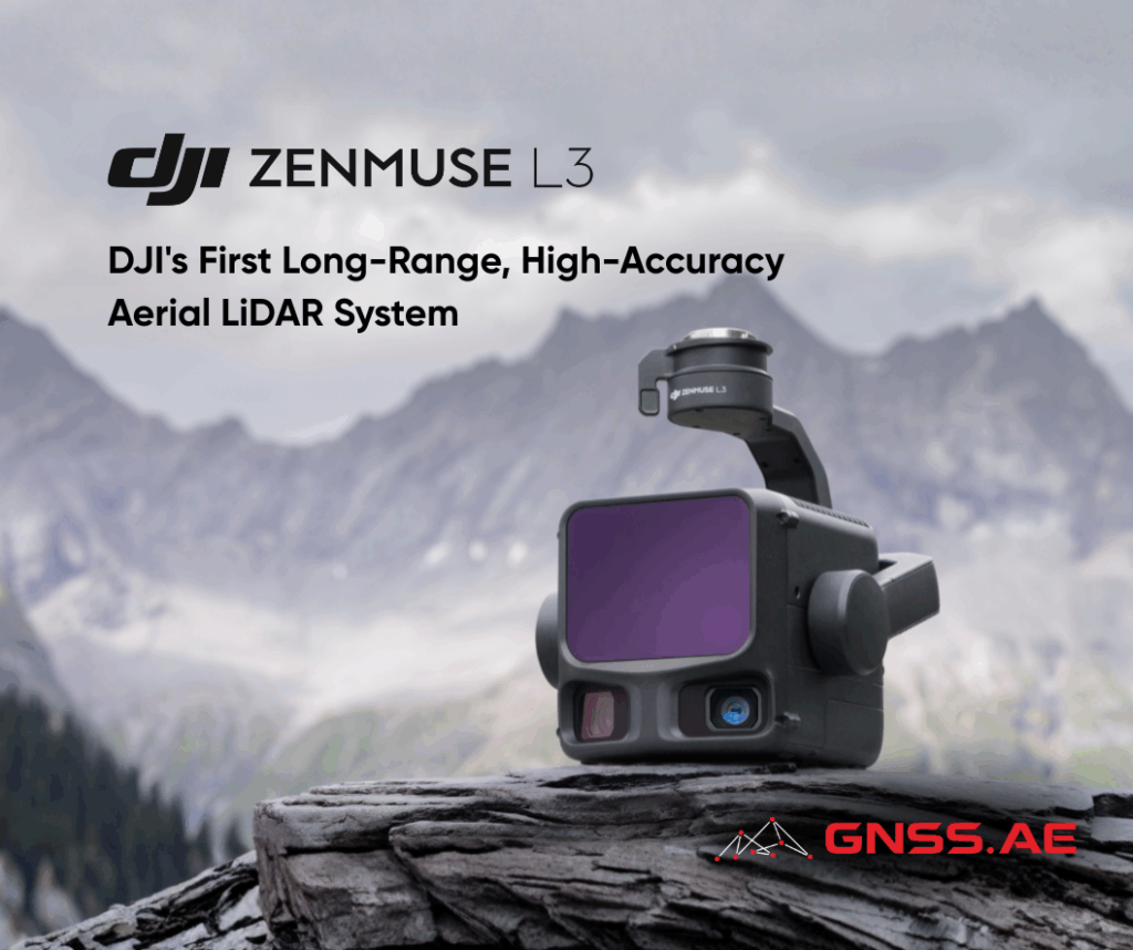
DJI continues to redefine the boundaries of aerial surveying with the launch of DJI Zenmuse L3, its most advanced LiDAR and mapping payload to date. Building upon the success of the Zenmuse L1 and L2, the new system represents a complete reengineering of aerial data acquisition, bringing together an ultra-long-range 1535 nm LiDAR, dual 100 MP RGB mapping cameras and a high-precision POS system in a compact, gimbal-stabilized design. The result is a payload capable of capturing high-density, survey-grade point clouds and photogrammetry-level imagery across vast areas—up to 100 km² per day, when paired with DJI Matrice 400 platform.
DJI Zenmuse L3 is a masterclass in integration and miniaturization. Within a single stabilized three-axis gimbal, DJI has combined four powerful components:
Despite its compact size, the payload delivers a level of performance previously associated with much larger airborne LiDAR systems. With a maximum detection range of 950 meters on surfaces with just 10% reflectivity, DJI Zenmuse L3 achieves extraordinary reach while maintaining millimeter-level consistency and precision.
At the heart of DJI Zenmuse L3 lies its 1535 nm long-range laser, a major advancement over the Zenmuse L2’s 905 nm system. This higher wavelength not only extends range but also enhances safety and atmospheric stability.
The adjustable pulse rate (up to 2 million pulses per second) allows operators to optimize between range, density, and power consumption depending on mission needs.
A beam divergence of just 0.25 mrad—around one-fifth that of the L2—produces a finer spot size, greatly enhancing detail resolution and object detection. This improvement is critical for applications like power line inspection, forestry and urban mapping, where the ability to distinguish small features or penetrate dense vegetation is essential.
The system supports up to 16 returns, providing exceptional ground point density even beneath canopy cover. Operators can choose between:
This flexibility of DJI Zenmuse L3 allows users to adapt instantly to the environment. Changing scanning modes lets users optimize precision or completeness without changing payloads, regardless of terrain or target.
The integration of dual 100 MP 4/3 CMOS RGB mapping cameras elevates DJI Zenmuse L3 beyond a traditional LiDAR payload. Each camera features a mechanical shutter and supports pixel binning for an effective 25 MP output, improving dynamic range and color accuracy under low light.
The system delivers a 107° horizontal field of view, meaning operators can capture both LiDAR and RGB data over broad swaths of terrain with minimal overlap. Even at 20% side overlap, users can generate high-resolution digital orthophotos (DOM) and digital elevation models (DEM) in a single flight, cutting operational time and cost dramatically.
DJI Zenmuse L3 sets a new standard in accuracy for UAV-based LiDAR and photogrammetry.
These figures make it suitable for high-precision mapping at 1:500, 1:1000, and 1:2000 scales, supporting engineering-grade deliverables such as topographic maps, volume calculations, and structural modeling.
The enhanced high-precision POS system delivers heading accuracy of 0.02° and pitch accuracy of 0.01° (post-processed, 1σ). Microsecond-level synchronization between the LiDAR, RGB cameras, and IMU ensures precise time alignment, reducing positional drift and improving model coherence.
At a 300 m flight altitude, DJI Zenmuse L3 achieves a 3 cm ground sample distance (GSD)—comparable to manned aerial survey systems. Combined with real-time position synchronization, the system operates without ground control points (GCPs), significantly accelerating workflows.
DJI Zenmuse L3 is not only built for precision, it is also engineered for speed. Its design allows surveyors to capture more data in less time without compromising accuracy or point density.
DJI Zenmuse L3’s optimal performance zone lies between 15–17 m/s, where it maintains a perfect balance between flight endurance, data density, and mapping accuracy. However, the system is capable of operating at speeds of up to 25 m/s, enabling rapid large-scale coverage when needed.
Why This Matters?
Enhanced stability at higher speeds translates into cleaner, denser, and more accurate point clouds, even during fast-moving flights. Speeds below 15 m/s further increase point cloud density and resolution, though they extend flight duration.
This range of operational flexibility makes DJI Zenmuse L3 suitable for both precision mapping and rapid-response missions, ensuring survey-grade results under a variety of field conditions.
When mounted on the DJI Matrice 400, Zenmuse L3’s efficiency is unmatched in its class.
This makes it ideal for large-scale corridor mapping, mining surveys, and topographic monitoring — scenarios that traditionally required multiple sensors or platforms.
The system simultaneously collects LiDAR and RGB data, producing DEM, DOM and 3D models in a single flight, streamlining acquisition and minimizing post-processing workload.
DJI has ensured that DJI Zenmuse L3 fits seamlessly within its professional mapping ecosystem, from mission planning to post-processing and data visualization.
The upgraded DJI Pilot 2 interface automates mission setup by recommending optimal parameters and generating density and point cloud distribution charts before takeoff. During flight, users can preview real-time 2D and 3D point clouds, monitor progress, and perform in-field measurements.
The split-screen mode allows simultaneous viewing of point clouds, RGB imagery, and Vision Assist feeds—crucial for safe navigation during power line or corridor missions. Additionally, DJI FlightHub 2 integration enables real-time cloud synchronization, allowing teams to analyze and share data as it’s captured.
DJI Zenmuse L3’s data is processed in DJI Terra, which supports Post-Processed Kinematic (PPK) correction and LiDAR Gaussian Splatting fusion-based reconstruction. This fusion technique merges LiDAR and RGB datasets to produce highly realistic 3D models with superior geometric and color fidelity—ideal for infrastructure and asset inspection.
DJI Terra’s Fusion-Based Modeling capability allows generation of point clouds, 2D maps, and 3D meshes from a single flight, enabling a unified workflow for industries like energy, construction, and transportation.
DJI Modify extends the workflow into analysis and output generation, providing:
This integration allows surveyors to move seamlessly from acquisition to deliverables without third-party software.
Recognizing the importance of data security, DJI incorporates CFexpress™ memory card encryption, AES-256 encrypted transmission, and one-click log clearing via DJI Matrice 400, ensuring data integrity throughout the mission lifecycle. Each DJI Zenmuse L3 unit is factory calibrated to guarantee consistency across units and field conditions, reducing the need for post-installation adjustments.
The new DJI Zenmuse L3 is more than an upgrade — it’s a technological leap that brings 1535 nm long-range laser technology, dual 100 MP RGB mapping cameras, and a high-precision POS system into a single, drone-mounted payload. DJI Zenmuse L3 empowers professionals to capture, process, and analyze geospatial data with unmatched accuracy and efficiency, from long-range topographic surveys to detailed infrastructure modeling.
For geospatial professionals, engineers, and survey organizations, DJI Zenmuse L3 represents the most comprehensive, end-to-end LiDAR mapping solution, capable of transforming how we capture, process, and analyze the world from above. As the leading dealer for DJI Enterprise in the Middle East and Africa, GNSS.AE offers professional guidance to help you integrate DJI Zenmuse L3 into your workflows.