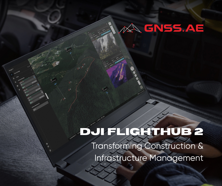
The architecture, engineering, and construction (AEC) industry is experiencing a digital revolution, and DJI is leading the charge with significant enhancements to DJI FlightHub 2. The newly launched Analyzer module introduces groundbreaking capabilities specifically designed for construction and infrastructure professionals, promising to reshape how projects are managed from the ground up.
Construction professionals have long struggled with four fundamental obstacles:
The enhanced DJI FlightHub 2 platform directly confronts these pain points through its comprehensive drone-based solution. When paired with the DJI Dock 3, the system creates an autonomous workflow that seamlessly integrates data capture, cloud-based 3D modeling, and sophisticated analysis capabilities. This integrated approach enables superior visual progress monitoring, enhanced safety oversight, streamlined regulatory compliance, and significantly improved operational efficiency.

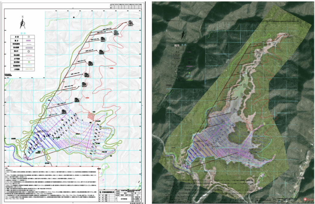
One of the most significant additions to DJI FlightHub 2 is its design file import functionality, which bridges the gap between architectural plans and real-world construction. The system accepts both PDF and DXF format blueprints, allowing users to precisely overlay design specifications onto drone-captured 3D models.
The platform offers multiple alignment methods, including custom parameter settings, control point matching, and manual positioning tools. This flexibility ensures accurate placement regardless of project complexity or site conditions. By enabling direct comparison between planned designs and actual construction progress, teams can identify discrepancies early and implement corrective measures before they become costly problems.
This capability proves particularly valuable in complex projects such as tailings dam construction, where engineers can monitor overall dam profiles against original specifications while tracking critical elements like drainage infrastructure and flood management systems in real-time.
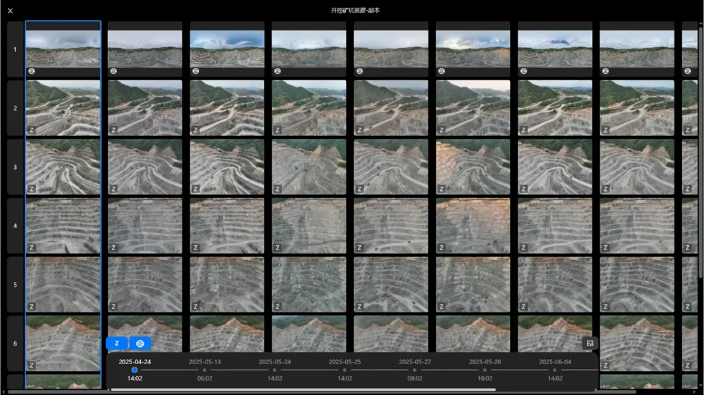
DJI FlightHub 2’s Timeline feature addresses the challenge of managing vast amounts of visual data collected over project lifecycles. By maintaining consistent flight paths across multiple data collection sessions, the system captures comprehensive datasets including RGB imagery, infrared data, panoramic views, and both 2D and 3D models.
The Timeline interface allows project teams to navigate chronologically through collected data, facilitating side-by-side comparisons from identical vantage points across different time periods. This temporal analysis capability provides unprecedented insight into project evolution, enabling teams to track localized changes and maintain clear visibility of overall progress trajectories.
The measurement capabilities within DJI FlightHub 2 represent a quantum leap in construction site analysis. The platform supports multiple measurement methodologies to accommodate diverse project requirements:
Fundamental Measurements include distance calculations (horizontal, vertical, and spatial), area and perimeter analysis (both spatial and horizontally projected), and altitude differential calculations between designated points.
Advanced Analysis Features encompass gradient calculations with support for multi-segment slope measurements, providing angle, percentage, and ratio data. The cross-section extraction tool enables comparative analysis across multiple timeframes and direct comparison with design drawings for deviation assessment.
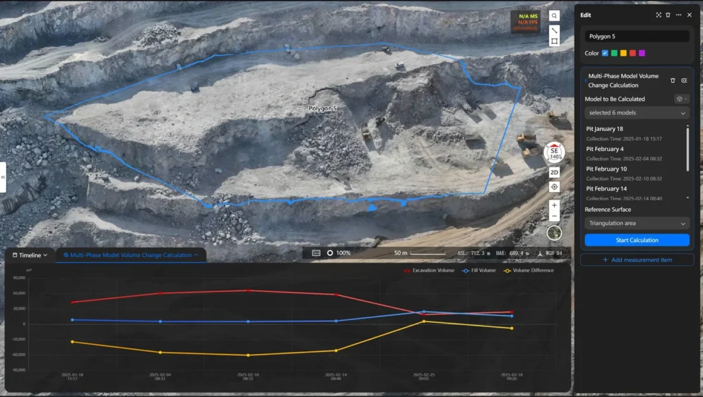
Volumetric Analysis capabilities support calculations across 2D models, 3D models, and point cloud data. Users can measure cut volumes, fill volumes, volume differentials, and total volumes with precision. The system supports custom baseline definitions including triangulated mesh surfaces, fitted planes, and horizontal references, while also accepting imported 3D design files for direct calculation.
Multi-phase volume change calculations overlay models from different time periods, providing accurate cut and fill measurements essential for construction management and progress verification.
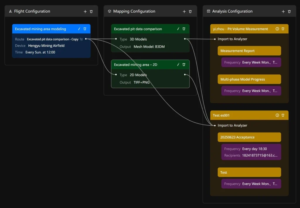
DJI FlightHub 2’s automation capabilities transform the entire data lifecycle from capture to actionable insights. The platform’s intuitive drag-and-drop workflow builder enables users to configure comprehensive end-to-end processes covering data acquisition, modeling, measurement, analysis, and report generation.
These automated workflows operate on scheduled intervals with minimal manual oversight, ensuring consistent data collection and analysis cycles. Custom measurement reports can be generated automatically, featuring selected measurement types, branded elements including company logos, and scheduled delivery to stakeholders.
While specifically enhanced for AEC applications, DJI FlightHub 2 Analyzer extends its capabilities across multiple vertical markets including infrastructure development, natural resource management, mining operations, security applications, emergency response, inspection services, and urban planning.
The platform’s comprehensive approach to data visualization and structured output generation supports digital decision-making across all aspects of construction management, from progress tracking and quality control to cost estimation and resource allocation.
As the construction industry continues its digital transformation journey, DJI FlightHub 2 positions itself as a catalyst for smarter, more efficient, and increasingly precise project management. By delivering integrated hardware and software solutions that address real-world challenges, DJI is empowering construction professionals to embrace data-driven operations and achieve new levels of project success.
The enhanced DJI FlightHub 2 platform represents more than technological advancement—it embodies the future of construction management, where precision, efficiency, and intelligence converge to create unprecedented possibilities for industry professionals.