DJI FlightHub 2 represents a major leap forward in drone operations management. By combining intelligent algorithms with a multimodal Large Language Model (LLM), this all-in-one cloud platform redefines how organizations plan, execute, and analyze aerial missions. Designed for professionals in public safety, emergency response, geospatial mapping, and infrastructure inspection, DJI FlightHub 2 delivers unprecedented levels of efficiency, automation, and precision.
With its air-to-ground integrated system, DJI FlightHub 2 provides complete visual oversight and centralized control. From remote operations to seamless data analysis, the platform simplifies even the most complex workflows. Below, we explore the key features that are setting a new standard in drone management.
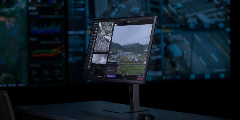
Effective command and control are essential for mission success. DJI FlightHub 2 strengthens these capabilities with an upgraded Virtual Cockpit and ground-to-cloud integration, enabling faster decision-making and improved collaboration.
Remote & Multi-Drone Control: Operate one or multiple drones directly via mouse and keyboard. Features such as Mouselook mode and drag-select zoom streamline camera adjustments, while synchronized multi-drone control enhances coordinated missions.
Smart Track & FlyTo: Detect, count, and track objects—such as vehicles or vessels—while receiving real-time alerts for anomalies. With one-click FlyTo tasks, drones automatically chart the safest and quickest route to a designated target, vital for emergency response.
AR Street: Overlay critical geographic data, including street names and building outlines, onto the live video feed, improving situational awareness in complex environments.
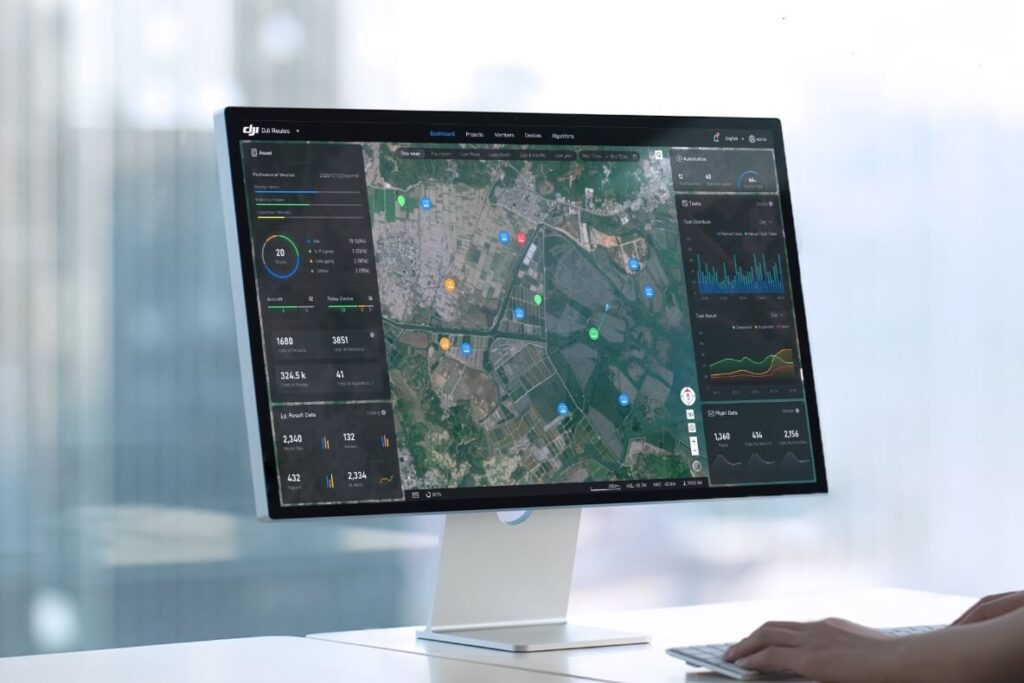
Dashboard & Live Annotations: Monitor drone status, mission progress, and flight statistics through a real-time dashboard. Teams can add annotations, plan routes, and assign tasks across devices with instant synchronization.
Livestream Sharing: Generate custom livestream links accessible via QR code, allowing stakeholders to monitor operations in real time without needing platform access.
Multi-Stream Monitoring: View multiple drone feeds on a single screen, ensuring comprehensive situational awareness during large-scale operations.
DJI FlightHub 2 integrates advanced perception tools and LLM-driven analysis to automate inspections and enhance accuracy.
Smart Detection: Built-in algorithms detect and classify objects such as vehicles and boats, with support for third-party algorithm integration for specialized needs.
Automatic Alerts: The system issues instant alerts while logging object type, location, time, and imagery for full traceability. Data can be compiled into intelligent reports for further analysis.
Smart Patrol: Combine object detection with pre-defined patrol routes, enabling drones to autonomously scan areas, detect targets, and trigger alerts—ideal for security and inspection workflows.
The integration of an LLM allows drones to not only capture data but also interpret it.
Multimodal Object Detection: Operators can search for specific objects via text or image input. The LLM identifies the target within live feeds and issues alerts, delivering enhanced situational awareness.
Multimodal Media Search: Quickly analyze large datasets of imagery and video using natural language or image-based queries, significantly accelerating post-mission reporting.
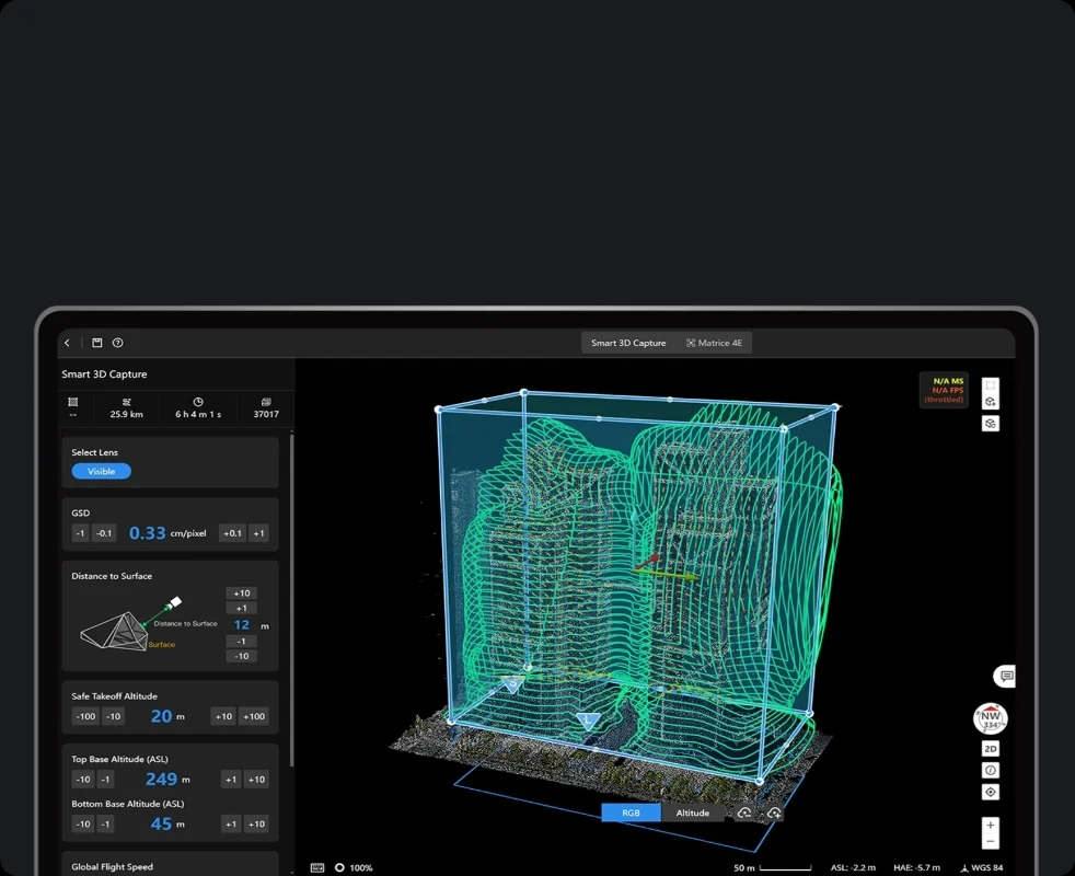
DJI FlightHub 2 makes complex mission planning intuitive with 3D route editing and customizable mapping tools.
Patrol & Inspection Routes: Build and adjust waypoint routes in 3D while configuring automated detection actions at each point.
Mapping Routes: Supports Area Routes for large-scale mapping and Linear Routes for corridors such as pipelines and roads.
Detailed Routes: Features like Smart 3D Capture, Slope Routes, and Geometric Routes simplify data collection for bridges, buildings, and other intricate structures.
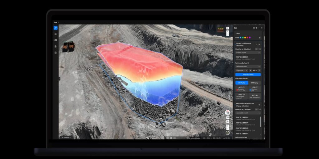
DJI FlightHub 2 streamlines the entire data pipeline—from collection to final report—through powerful cloud-based tools and automation.
Cloud Modeling and Analysis
Cloud Modeling: Generate high-precision 2D/3D models and point clouds, with support for real-time 2D reconstruction during flight when paired with compatible DJI drones.
Analyzer: Import design files (PDF, DXF) for overlay on models, track changes with timeline tools, and perform detailed measurements of distance, area, and volume.
Automated Workflows
Automated Operations: Schedule missions where drones execute flights, upload data, and initiate modeling without manual input.
Workflow Builder: Use a drag-and-drop interface to design end-to-end workflows connecting data capture, processing, analysis, and reporting—ideal for continuous monitoring and long-term projects.
DJI FlightHub 2 is built for scalability, offering flexible integration and enterprise-grade security.
OpenAPI: A RESTful API enables integration with third-party platforms, reducing development costs.
FlightHub Sync: Simplifies syncing of media files, livestreams, and data with cloud systems without requiring coding.
On-Premises Deployment: For organizations with strict data governance, DJI FlightHub 2 can be installed in a fully isolated intranet environment.
DJI FlightHub 2 represents a pivotal advancement in drone management. By combining AI-driven insights, seamless collaboration, and fully automated workflows, it empowers organizations to operate more efficiently, enhance safety, and maximize the value of aerial data.