By: Dr. Amin Abd Elraheem (Ph.D., Training Manager)
In recent years, the rise of unmanned aerial vehicles (UAVs), or drones, has transformed a wide array of industries by their capabilities in the fields of inspection and monitoring. Some of the transformative and promising applications are in the field of environmental monitoring. Among the various environmental challenges, air pollution stands as one of the most pressing, with severe implications for human health, ecosystems, and the global climate. As traditional methods of air monitoring, such as ground-based sensors and stationary air quality stations, struggle to provide comprehensive, real-time data across expansive regions, drone-based systems have emerged as powerful tools for air pollution detection and analysis. Equipped with a range of sensors, including electrochemical sensors, particulate matter (PM) sensors, and multi-gas detectors, drones are now enabling scientists, governments, and organizations to monitor air pollution with unprecedented flexibility, accuracy, and efficiency.
This article explores the various applications of drones for air pollution detection, introduces the sensors and technologies involved, focusing on the cutting-edge technologies and solutions of multi-gas detectors. It also highlights the benefits associated with using UAVs in environmental monitoring.
Drone-based systems offer a fast, flexible, and cost-effective way to monitor air pollution across large or hard-to-reach areas. Equipped with advanced sensors, they measure key pollutants like PM (Particulate Matter), NO₂ (Nitrogen Dioxide), VOCs (Volatile Organic Compounds), CH₄ (Methane), and more, at multiple altitudes and locations.
They enable:
By delivering high-resolution, georeferenced data, drones empower environmental agencies, researchers, and first responders to act faster, smarter, and safer.
Drones that are used for air pollution monitoring are equipped with a variety of sensors designed to detect specific pollutants. The following table introduces some of the common sensors as well as their characteristics:
| Sensor Type | Detectable Gases/Pollutants | Technology | Best Use Cases | Response Speed |
| Electrochemical Sensors | CO, NO₂, SO₂, O₃, H₂S, Cl₂ | Gas-specific chemical reaction | Urban monitoring, industrial sites | Fast (≤30 sec) |
| NDIR Sensors | CO₂, CH₄, some VOCs | Infrared absorption | Methane/CO₂ monitoring, landfill sites | Fast (~1–10 sec) |
| TDLAS (Laser-based) | CH₄, CO₂, NH₃ | Tunable Diode Laser Absorption | Pipeline inspection, oil & gas leak detection | Very fast (<1 sec) |
| PID (Photoionization Detector) | VOCs (e.g., benzene, toluene) | UV ionization | Industrial VOC monitoring, HazMat zones | Very fast (1–2 sec) |
| Optical PM Sensors | PM1.0, PM2.5, PM10 | Laser scattering | Urban air quality, wildfire smoke, dust sources | Moderate (5–10 sec) |
| Thermal Cameras | Indirect gas leaks (thermal plumes) | Infrared thermography | Leak detection (hot/cold spots), refinery safety | Near real-time |
| FTIR (Fourier Transform Infrared) spectroscopic systems | CO, NOx, SO₂, NH₃, VOCs (complex mixtures) | Infrared spectroscopy | Scientific studies, regulatory monitoring | Slow (~10–60 sec) |
| Multi-Gas Systems | CO, CO₂, NOx, SO₂, O₃, VOCs, H₂S, CH₄, Cl₂, PM | Integrated electrochemical, NDIR, PM | Comprehensive surveys, emergency response | Fast (real-time) |
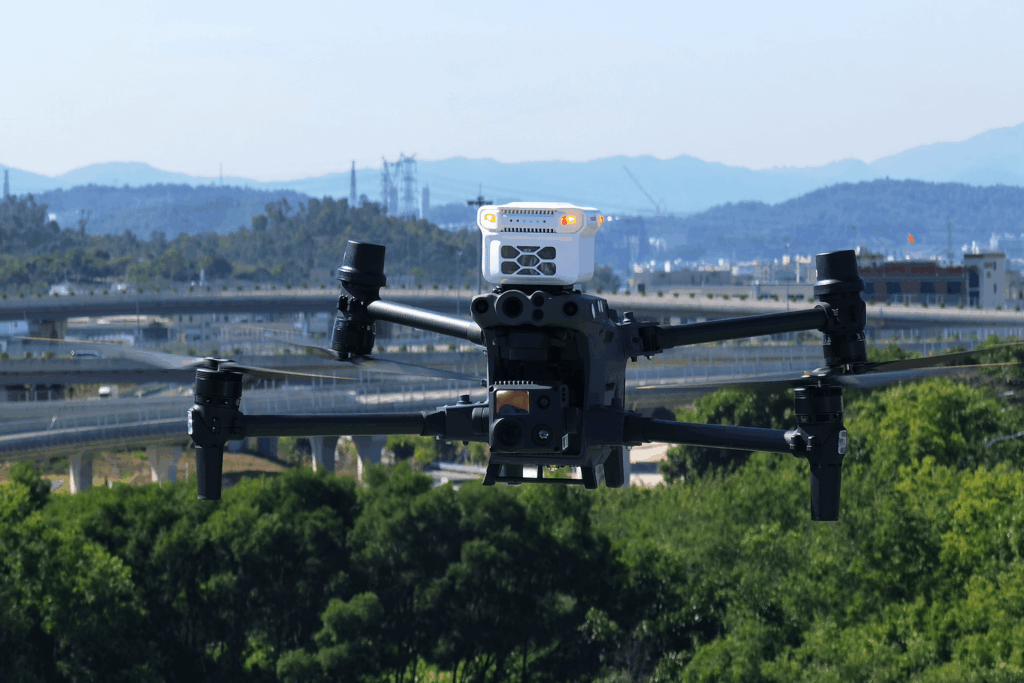
As shown in the previous table, multi-gas systems are the most versatile and practical drone-based detection systems. One such system is Soarability’s Sniffer4D, a cutting-edge air pollution detection solution that takes drone-based environmental monitoring to the next level. This system combines high-precision sensors, real-time data processing, and advanced analytics to provide a comprehensive, multidimensional view of air quality in diverse environments.
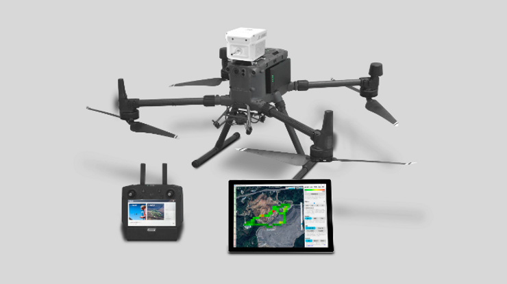
The Sniffer4D ecosystem combines the multi-gas detection unit which integrates with the drone and the Sniffer4D Mapper software, helping to analyse spatial distributions of particles and air pollutants and identify sources and transportation of air pollution.
This system is able to measure and visualize real-time 3D gas concentration distributions. By providing timely & actionable information, Sniffer4D helps first responders, oil & gas industry, environmental agencies, and researchers improve work efficiency, mitigate risks, and reduce costs.
Sniffer4D is able to obtain up to 9 gas concentration distributions at one time. Users can flexibly choose or alter their sensor configurations that suit their applications and budgets. Examples:
Moreover, each detected gas could be individually georeferenced, and operators can also obtain temperature and humidity data for each section of the dataset.
Sniffer4D Models Highlights:
These Sniffer4D models offer a flexible and scalable suite of tools for high-resolution, real-time gas monitoring across diverse operational needs, whether mounted on drones, ground vehicles, or carried by hand.
Sniffer4D is playing an increasingly important role in revolutionizing the way air pollution is monitored, both in urban and remote settings. The following section highlights the capabilities and typical applications of Sniffer4D, together with user cases, and shows how it is enhancing the potential of drones for comprehensive air pollution detection.
Hyper-local environmental monitoring is the practice of closely observing and assessing environmental conditions within a very small geographical area, such as a neighborhood or street. This approach provides detailed, real-time information about specific pollution sources, localized climate impacts, and the effectiveness of sustainability initiatives at a detailed level. Sniffer4D can be deployed on drones and quickly scan through an area, in order to obtain its hyper-local air pollution distribution in 2D or 3D. This data is invaluable for tracking the effects of localized sources of pollution, such as: vehicle emissions and industrial exhausts.
By conducting regular flights, local governments, researchers, and urban planners can gather real-time data to create a detailed map of pollution hotspots. This enables targeted interventions, such as modifying traffic flow, relocating industrial operations, or enforcing stricter emissions regulations. It also provides insights into the spatial distribution of air pollutants, helping public health officials understand how specific areas are affected by pollution.
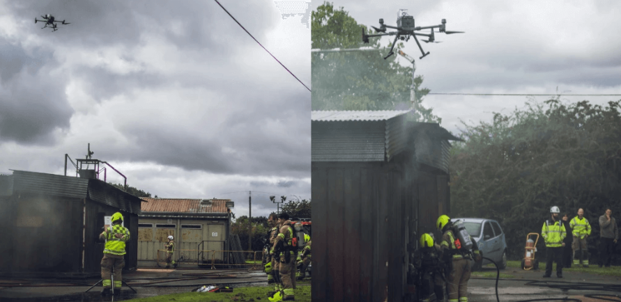
User Case: Drone-mounted Pollution Detection
The nearby residents in a densely distributed area near an industrial park have complained that they smelt odors similar to the rotten egg and NH3, hoping that the local authorities would deal with the issue.
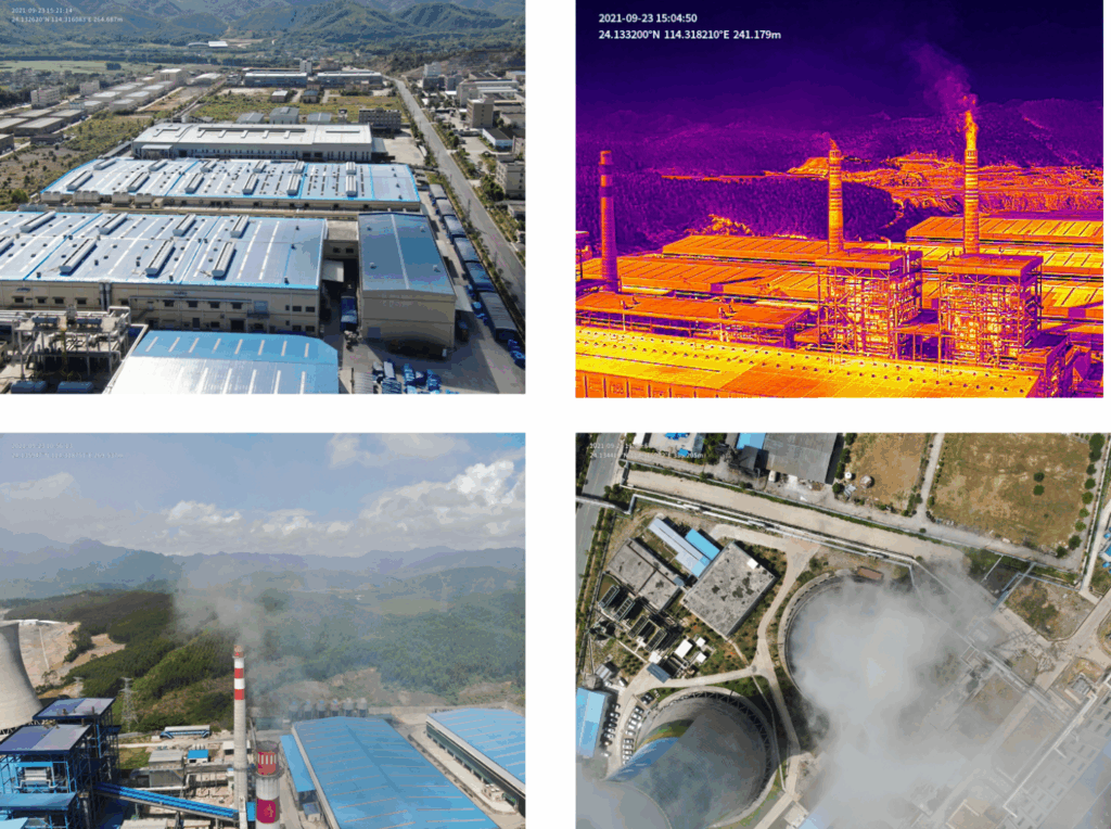
To address this issue, the inspection crew operated a thermal drone combo: in this case DJI M300 RTK drone, equipped with Zenmuse H20T, in addition to Sniffer4D V2, together with DJI Terra and Sniffer4D Mapper, in order to quickly scan the pollution emission above the industrial park and searched for the suspicious emission vents through the infrared thermal images.
The investigation focused on the living areas and schools located within 5km from the industrial park and its downwind area. Sniffer4D transmitted the real-time concentrations to the ground end and revealed that the concentrations of PM2.5, PM10, NO2, SO2 were extremely high.
When a hazardous material (HazMat) is released into the atmosphere, its pollutants can spread rapidly, which can pose serious risks to both human health and the environment. The real-time, high-precision data collected by Sniffer4D plays an essential role in HazMat response by allowing emergency response teams to quickly assess the extent of pollution and toxic exposure from a safe distance.
User Case: HazMat Demonstration with Sniffer4D
The demonstration goal was to show the capabilities of a drone-based multi-gas detection system, for public safety and HazMat operations.
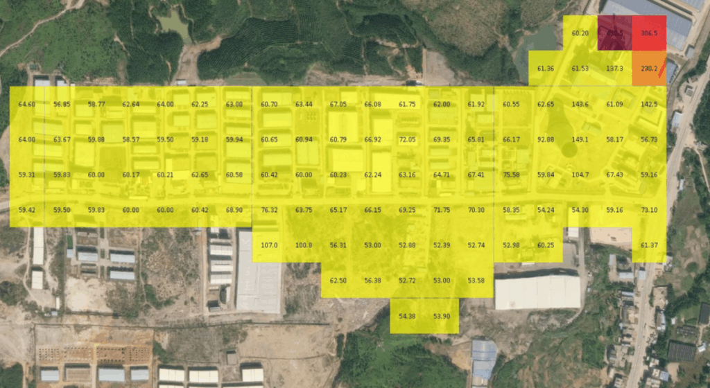
Flown above a smoking building, the module quickly identified numerous air pollutants, providing real-time insights. It didn’t only detect different gases, but also revealed their location, concentration and direction of travel.
During the trial, the module detected numerous gases/substances, such as nitrogen dioxide (NO2), carbon monoxide (CO), and PM2.5. The below graphic shows the 2D grid four of the substances detected and demonstrates how operators can toggle between them to obtain crucial insights.
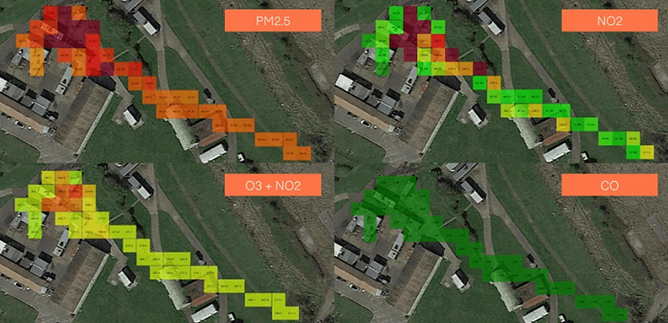
Notice how the concentration of each substance is reflected by numerical values and different colours. The operators could also obtain further information thanks to the possibility of viewing the results as 2D contours or 3D maps.
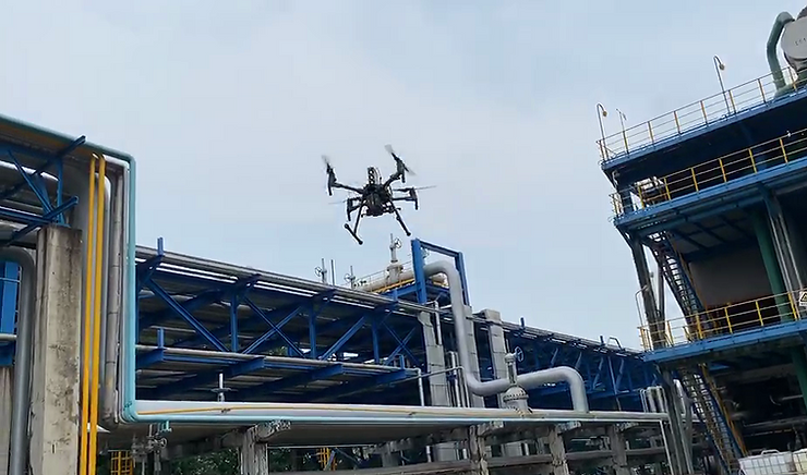
Identifying leaks of hazardous gases or other pollutants is crucial for minimizing environmental damage, ensuring public safety, and maintaining regulatory compliance. Sniffer4D excels in leak detection by providing a mobile, real-time monitoring solution that can quickly pinpoint the exact source of emissions in hard-to-reach locations. This is particularly beneficial in industries where even small leaks can lead to catastrophic consequences, such as the oil and gas industry.
When integrated with drones, Sniffer4D can be flown over pipelines, storage tanks, gas refineries, or any other infrastructure susceptible to gas leaks. The system can detect a wide range of gases such as CH₄, CO, SO₂, and VOCs.
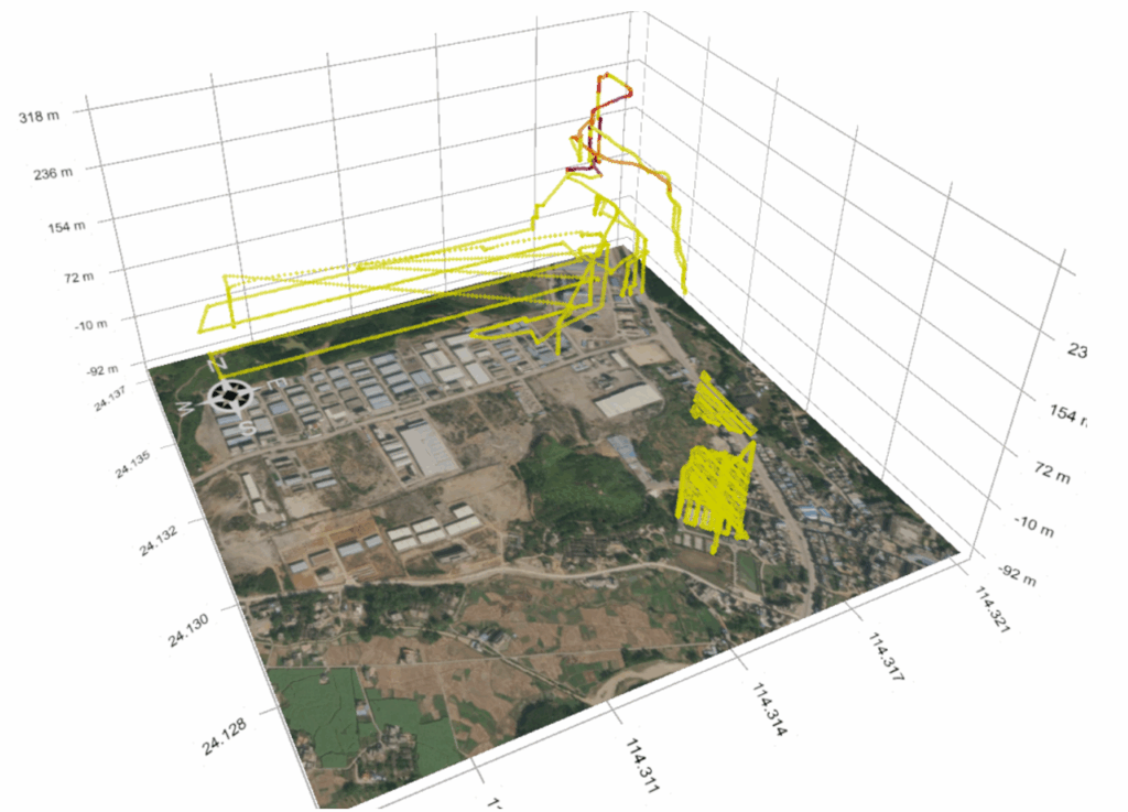
User Case: Sniffer4D for Pipeline Inspection
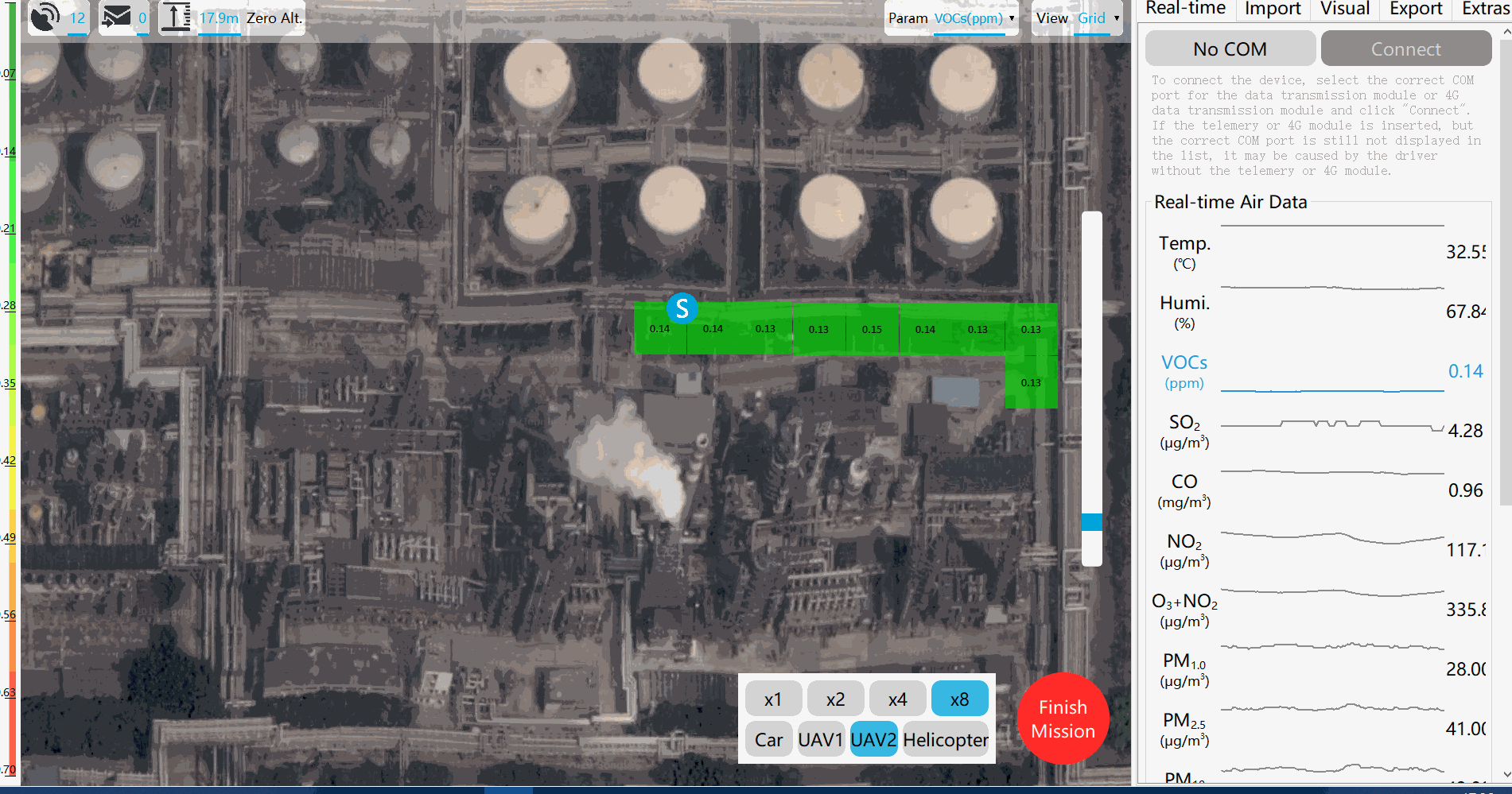
The generated map shows three areas where the VOCs concentration is significantly higher than the background, which indicates that Sniffer4D quickly detects three key areas and boosts the efficiency of the inspection.
The use of the drone-mounted Sniffer4D gas detection system in pipeline inspections has demonstrated several advantages over traditional manual methods, including flexibility, short preparation time, real-time data collection and transmission, enhanced and automated reports generation.
Shipping is one of the largest contributors to air pollution, with vessels releasing significant amounts of pollutants such as sulfur oxides (SOx) and others. To combat these emissions, international regulations such as the International Maritime Organization’s (IMO) 2020 Sulfur Cap have been introduced to reduce the sulfur content in marine fuels. However, monitoring compliance with these regulations has traditionally been difficult, as it requires frequent inspections of ships at sea.
Drone-based Sniffer4D systems offer a solution by enabling ship emission monitoring by measuring the sulfur emissions and smoke plumes emitted by their exhaust stacks. Drones can track ships as they enter or leave ports, assessing whether they comply with global sulfur emission limits or whether they are violating environmental standards.
The drone-based monitoring system works by flying over the ship or following it across waterways, using real-time data to assess pollutants. This provides:
Example of Use Case:
There are other applications where Sniffer4D systems have proved their effectiveness, such as monitoring of volcanic degassing and monitoring of mining dust .
Despite facing some challenges such as weather constraints and regulatory restrictions, the integration of drone technology into environmental monitoring offers a multitude of benefits that go far beyond the capabilities of traditional air monitoring systems:
Drones equipped with advanced sensors, such as Sniffer4D, have become a pivotal tool in air pollution monitoring. Their ability to provide real-time, high-resolution data across diverse and hard-to-reach environments offers significant advantages over traditional monitoring. By detecting a wide range of pollutants like particulate matter (PM), volatile organic compounds (VOCs), nitrogen dioxide (NO₂), and methane (CH₄), drones enable precise mapping of air quality in 2D and 3D spaces, enhancing the accuracy of pollution assessments.
Their mobility allows for rapid deployment in urban areas, industrial sites, and emergency scenarios, enhancing safety by reducing human exposure to hazardous environments. Drones also improve efficiency and cost-effectiveness compared to traditional monitoring methods, offering real-time, spatially-resolved data that supports smarter decision-making in environmental management, regulation enforcement, and disaster response.
As drone technology advances, its integration into environmental management frameworks will enhance pollution tracking, regulatory enforcement, and real-time decision-making, thereby supporting more effective mitigation of air quality issues and contributing to public health and ecological preservation.