5-band universal video multispectral camera Yusense AQ600 Pro:

Referring to the eutrophic state ev-aluation standard, the classification index is constructed by using the characteristic spectrum to realize the classification inversion and spatial information statistics of watereutro-phication, to assist the analysis of the impact of farmland wastewater, fishery and aquaculture on the surr-ounding water body, and to assist the investigation of pollution sources and water environment assessment.


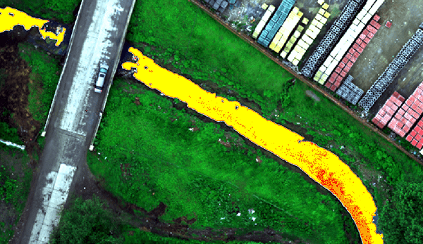
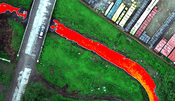
With reference to the evaluation standard of surface black and odorous water body, the classification index is constructed by using the characteristic spectrum to realize the hierarchical inversion and spatial information statistics of black and odorous water body, and to assist the analysis of the impact of domestic sewage and in-dustrial wastewater on the surrounding water body to assist the investigation of pollution sources and the assessment of water environment.
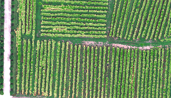
Vegetation index was constructed based on the fingerprint spectrum of vegetation to complete the spatial distribution and area statistics of target vegetation in the designated area, and to provide quantitative vegetation canopy density data for scientific research and production inagriculture, forestry and grass, ecology and other fields.


By using vegetation factors such as NDVI and LAI, quantifying the consistency of vegetation canopy status at different spatial scales, and using characteristic spectra of vegetation in different health states to quantitatively assess ve-getation growth,which can prov-ide data support for irrigation, fe-rtilization, plant protection, yield evaluation and other work.
| Indicator name | AQ600 Pro |
| Combination method | 5 multispectral channels + 1 RGB channel |
| Target size | Multispectral: 1/1.8”; RGB: 1/2.3” |
| Effective Pixels | Multispectral: 3.2Mpx; RGB: 12.3Mpx |
| Shutter type | Multispectral: Global; RGB: Rolling |
| Quantization bit number | Multispectral: 12bit; RGB: 8bit |
| Field of view | Multispectral: 48.8°×37.5°; RGB: 47.4°×36.4° |
| Ground resolution | Multispectral: 5.28cm@h120m; RGB: 2.60cm@h120m |
| Coverage Width | Multispectral: 109m×82m@h120m; RGB: 106m×79m@h120m |
| Spectral channel [1] | 450nm@30nm, 555nm@27nm, 660nm@22nm, 720nm@10nm,840nm@30nm, RGB |
| Optical Window | Sapphire optical glass window |
| Host size | ≤130mm×160mm×165mm (optical axis vertical to the ground) |
| Host weight | ≤780g |
| Mounting interface | X-Port |
| powered by | X-Port |
| Power consumption | ≤35W |
| Image Format | Multispectral: 16-bit raw TIFF & 8-bit reflectance JPEG RGB: 8-bit JPEG (including GPS, ambient light information) |
| Video Format | MP4 |
| Storage Media | Standard 128G, maximum support 2T USB3.1 storage device |
| Processing software | Yusense Map/Yusense Map Plus |
| parameter settings | DJI Pilot |
| Shooting trigger | Overlap rate trigger, timing trigger |
| Shooting frequency | Photo mode: 1Hz (related to the actual read and write speed of the storage medium); Video mode: 20Hz |
| Working temperature | -10℃~+50℃(Relative wind speed≥1m/s) |
| Storage temperature | -30℃~+70℃ |
| environment humidity | RH(%)≤85%(non-condensing) |
| certified product | CE, FCC, RoHS |
Note: [1] Standard wavelengths allow customization of the following 18 wavelength combinations: 410nm@35nm, 450nm@30nm, 490nm@25nm, 530nm@27nm, 555nm@27nm, 570nm@32nm, 610nm@30nm, 650nm@27nm, 660nm@22nm, 680nm@25nm, 720nm@10nm, 720nm@15nm (Qualcomm), 750nm@10nm, 780nm@13nm, 800nm@35nm, 840nm@30nm, 900nm@35nm, 940nm@35nm (tolerance ±5nm).
Inquire price for Yusense AQ600 Pro