Surveying plays a critical role in construction, land development, and infrastructure projects. For many years, traditional ground-based methods such as total stations, GNSS, and leveling have been the standard for delivering accurate and reliable results.
Today, drone surveying has become an increasingly popular method for collecting spatial data quickly and efficiently. Drones can capture large areas in a short time and generate detailed maps and 3D models. However, despite these advantages, drone surveying does not completely replace traditional surveying methods. Each approach has its own strengths, and in most projects, they are used together.
Traditional surveying is based on direct ground measurements using precise instruments. It has been the standard surveying approach for decades and is still considered the most reliable approach for high-accuracy work.
The most common surveying instruments include:
These methods remain widely used because they provide consistent, highly accurate, and repeatable results. They are also widely accepted for legal, cadastral, and engineering applications where accuracy and traceability are critical.
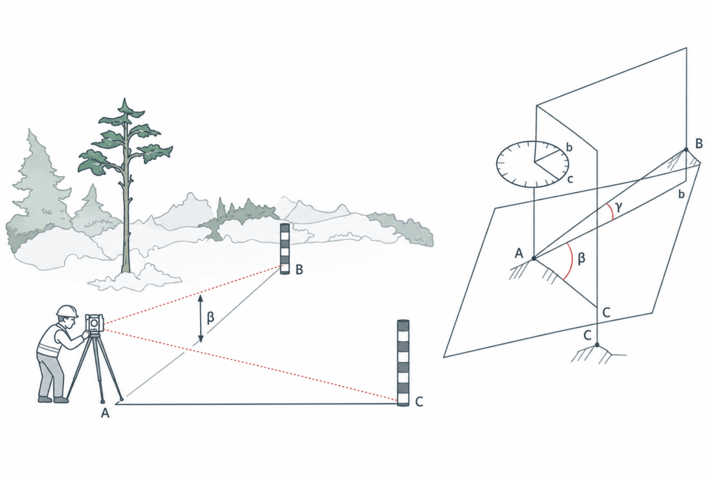
Figure 1 illustrates how a total station is used to measure angles and distances from a fixed point (A) to determine the position of other points (B and C). This principle is widely used in establishing control points and survey networks.
Drone surveying uses UAVs (drones) equipped with cameras or LiDAR sensors to collect aerial data. The collected data is processed using specialized software to create orthomosaic maps, digital elevation models (DEM), and 3D models.
Key technologies include:
Drone surveys are especially useful for large areas, construction monitoring, and sites that are difficult to access.
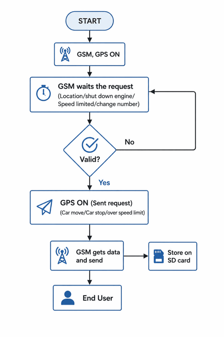
Figure 2 shows how GNSS systems receive, process, and transmit positioning data. The system validates requests, collects GPS data, and sends it to the user or stores it for further use.
Accuracy is one of the main points to consider when comparing traditional and drone surveying.
Some of the key factors include:
In many real-world projects, drone data is first used for quick mapping and visualization, but it is later checked and adjusted using ground control points to improve accuracy.
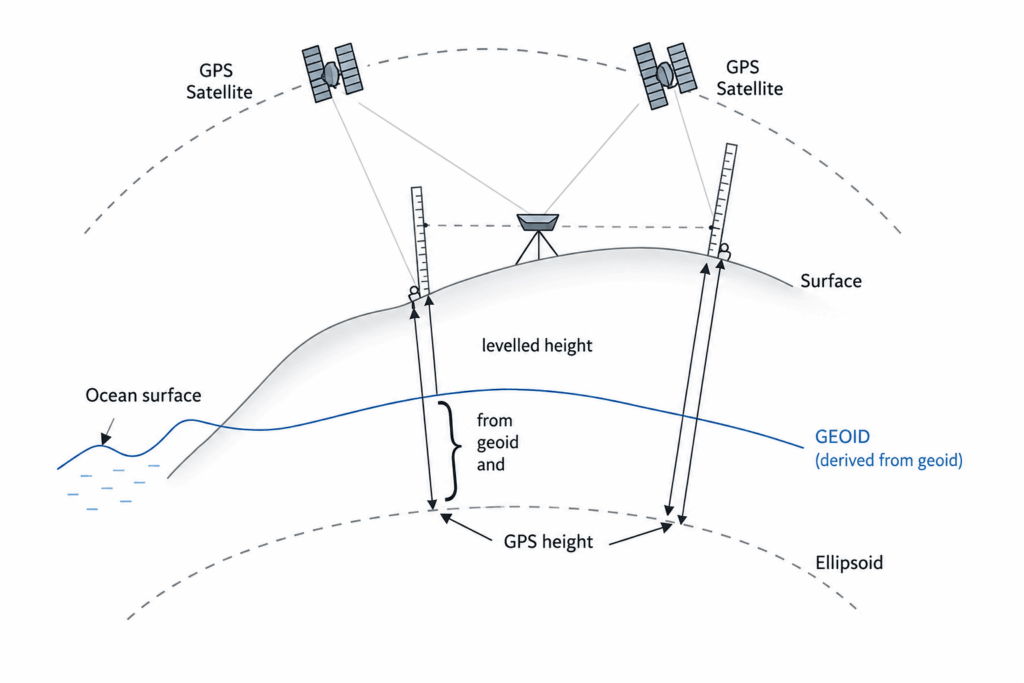
Figure 3 explains the difference between GNSS-based heights and leveling heights. GNSS measurements are referenced to an ellipsoid, while traditional leveling is based on the geoid. Understanding this difference is important for accurate elevation measurements
Drone surveying offers a major advantage in terms of speed. Large areas can be surveyed in a short time with minimal manpower. This makes drones ideal for projects such as construction monitoring, mining, and land development.
In addition, drones improve safety by reducing the need for surveyors to work in hazardous environments such as steep terrain or active construction zones.
Traditional surveying, while more time-consuming, is still necessary when very high accuracy is required.
Drone surveying is suitable for:
Traditional surveying is generally preferred for:
In practice, both methods are often combined to achieve the best results.
Modern surveying projects typically use a combination of both techniques. A common workflow includes:
This approach ensures both efficiency and accuracy
In the UAE, surveying activities must follow strict regulations and standards. All survey data must be tied to approved geodetic control networks to ensure accuracy and consistency. Drone surveys are widely used in the UAE, especially in construction and infrastructure projects. However, they must be supported by ground control and proper validation before being accepted for official use.
Drone surveying has transformed the way spatial data is collected by significantly improving efficiency and reducing field time. However, traditional surveying remains essential for applications that require high accuracy and legal reliability. Rather than replacing traditional surveying methods, drone technology is most effective when integrated with them. By combining both approaches, surveyors can achieve accurate, reliable, and efficient results across a wide range of projects.