
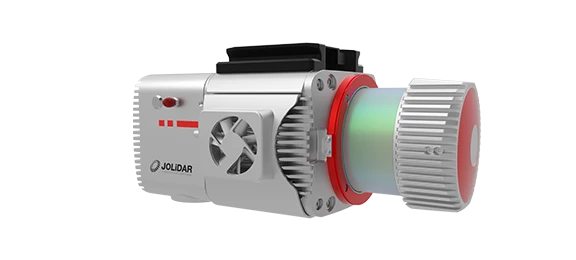
The JoLiDAR-LR22 is a high-performance, long-range LiDAR scanner designed for professional UAV applications. Engineered to meet the demands of modern surveying and mapping applications, this advanced system seamlessly integrates laser scanning, IMU technology, RGB imaging, and data acquisition capabilities for unrivaled performance in every scenario.


Elevation error less than 2cm without ground control points (GCPs).

Reach distances exceeding 1845 meters at 80% reflectivity.

Generate detailed 3D models with a rate of 1.5 million points per second.

20km² covered in a single flight on CW-25E (at a scale of 1:500).

Extract detailed topographic data from dense vegetation with ease.

Capture comprehensive data with ease no matter the environment or angle.

61MP resolution for capturing high-quality imagery alongside LiDAR data.

Simplify the setup process, saving time and resources.
The JoLiDAR-LR22 delivers impressive accuracy, achieving vertical accuracy better than 3cm and horizontal accuracy better than 5cm. This is complemented by high repetition accuracy of 5mm, indicating the system’s consistency in capturing repeated measurements under identical conditions.
Boasting a staggering 1845+ meter maximum scanning distance at 80% reflectivity, the JoLiDAR-LR22 excels in surveying large areas, mapping vast landscapes, and inspecting remote infrastructure.
This LiDAR sensor utilizes a narrow infrared laser beam boasting a narrow 0.5 milliradian (mrad) divergence. This ensures precise measurements, minimizing noise and enhancing data accuracy for superior 3D representations of the scanned environment.
The JoLiDAR-LR22 flies through scans at up to 200 lines per second, capturing vast areas in a flash. Its effective measurement rate of 1.5 million points per second packs even more detail into each scan, revealing incredible intricacies.
With 15 returns, this LiDAR system captures up to 15 individual data points from a single laser pulse, resulting in richer, more detailed point clouds. Imagine mapping a forest – with 15 returns, you capture ground, leaves, branches, and hidden details under the canopy.
Unlike LiDAR systems with a narrower FOV, a 360° system captures data from all directions in a single pass, ensuring complete coverage of the area of interest. This saves time and avoids the need for multiple scans from different angles.
Combined Real-Time Kinematic (RTK) positioning with Inertial Measurement Unit (IMU) data, this fusion allows for accurate georeferencing of data, ensuring that every point in your dataset is precisely located in the real world, even in the most challenging environments.
The 61 MP sensor enhances LiDAR point cloud clarity by capturing detailed visual information for precise object and surface texture identification. Its full-frame sensor (35.7×23.8mm) captures more light for improved low-light performance and potentially sharper images. With a 21mm focal length, it offers a wider field of view for efficient coverage of larger areas in each image.



Inquire price for JOUAV JoLiDAR-LR22