
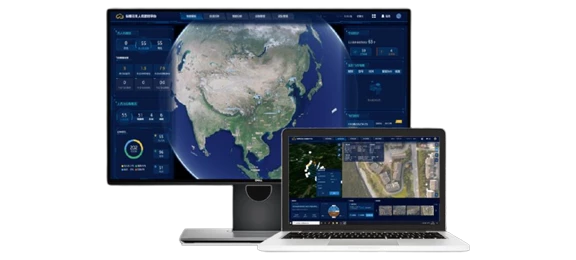
JOUAV’s Jocloud management platform is designed to manage the JOUAV Unattended System and its drones. The platform offers 3D route planning, route task management, simultaneous control of multiple drones, map information labeling and sharing, full dynamic video application, and AI recognition algorithms. Additionally, the system generates a detailed electronic flight report after each UAV flight.
Inquire Now

Based on 3D GIS map, Jocloud Management Platform provide ground-aware area and route search with ground-like routes

By the task requirements, superiors can effortlessly assign route missions to subordinates remotely with just a click, making the process of task delegation smooth and effortless.

Multiple UAVs can be controlled remotely at the same time, enhancing the cooperative operation capability of UAVs.

The key targets can be marked, measured, and shared on the map with other members to provide quantitative data for situational research and timely decision-making.

Integrated transmission solution with point, line and surface mapping and measurement in the dynamic video, synchronized with GIS map display, and share the marking information with other members.

The UAV video data is transmitted back to the command hall in real-time, supporting up to 9 split screens to be displayed simultaneously with a picture delay of 600ms or less.

The system supports vector file import, which can be superimposed on the dynamic video display in real-time to provide an intuitive inspection experience.

During the inspection, the video of the gimbal camera can be projected on the 3D map, which improves the user’s real-time perception.

The system can fast-patch the video keyframes in real-time and display the results on a 3D map or save them locally. This allows users to efficiently obtain the first orthophoto image of the target area.
Inquire Now
Read more
Inquire Now
Read more
Inquire Now
Read more
Inquire Now
Read moreInquire price for Jocloud