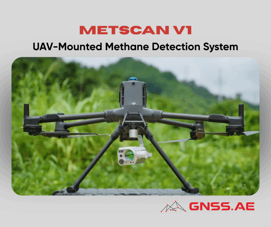
As global energy operators strengthen their commitment to safety, emissions reduction, and operational efficiency, fast and accurate methane leak detection has become a critical priority. MetScan V1 by Soarability is a cutting-edge solution designed specifically for this mission—combining advanced laser sensing, intelligent data analytics, and UAV mobility to deliver industry-leading methane inspection capabilities.
Fully compatible with the DJI Matrice 400 and DJI Matrice 350 platforms, MetScan V1 transforms drone platforms into high-precision remote gas sensing tools. Whether deployed over pipelines, well sites, industrial facilities, landfills, or high-rise buildings, it enables operators to detect fugitive emissions from a safe distance and make informed decisions faster than ever before.
MetScan V1 is a UAV-mounted methane 3D scanning system engineered for rapid and efficient leak detection in the natural gas industry. It leverages Open-Path Tunable Diode Laser Absorption Spectroscopy (OP-TDLAS) to remotely detect CH₄ emissions over large or inaccessible areas—without requiring field personnel to approach hazardous zones.
Soarability MetScan V1 is optimized for a wide range of applications, including:

MetScan V1 OP-TDLAS methane sensor delivers industrial-grade accuracy and reliability.
The Maximum Detection Distance (MDD) and Lowest Detection Limit (LDL) depend on several field factors, including:
Typical results under real conditions:
This range performance allows operators to inspect assets safely from a distance, even when gas concentrations are low or environmental conditions are challenging.
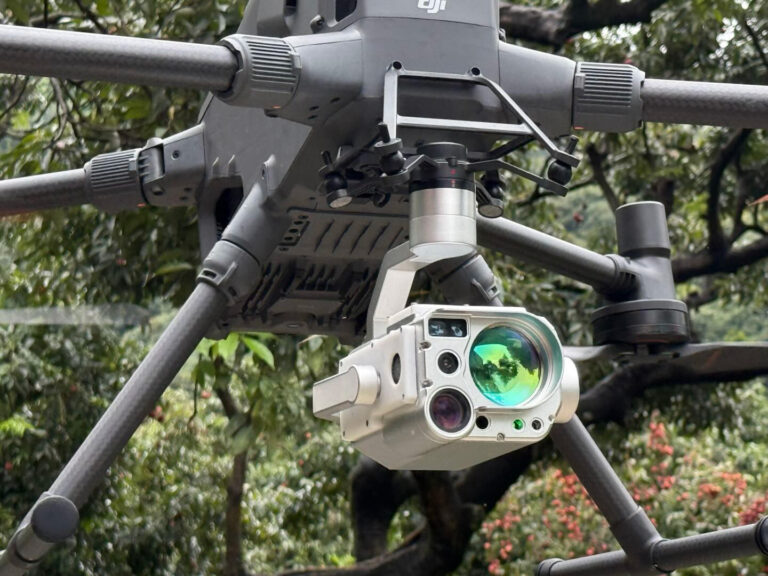
Soarability’s specially engineered 3-axis gimbal ensures:
This stability is essential for accurate methane detection in windy, dynamic, or high-altitude environments.
The onboard laser rangefinder provides:
Together with gimbal altitude and positional data, the system calculates:
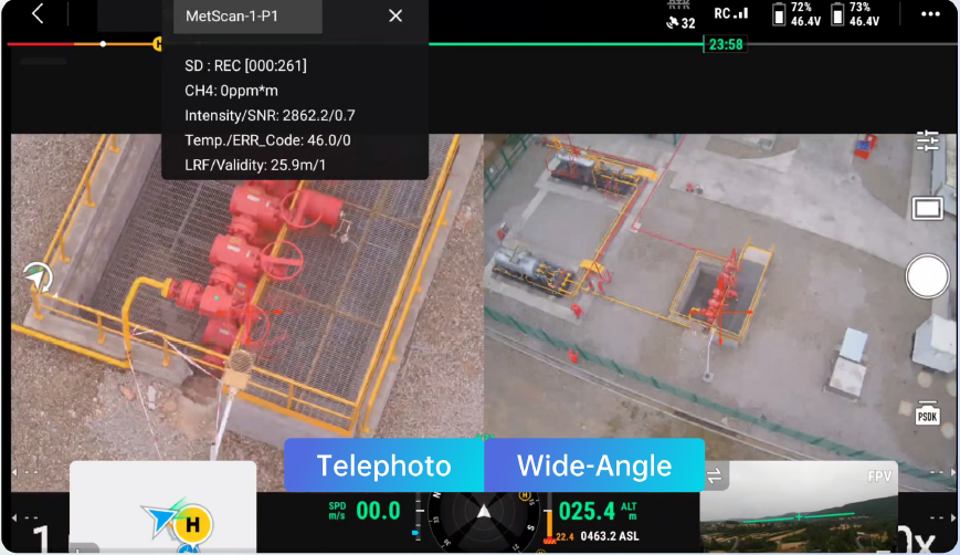
MetScan V1 includes two integrated cameras:
Both views are fused in real time, enabling operators to simultaneously observe the broader environment and zoom in on specific valves, joints, or risers.
MetScan V1 works seamlessly with SSI, a browser-based platform for real-time monitoring and advanced post-flight analysis.
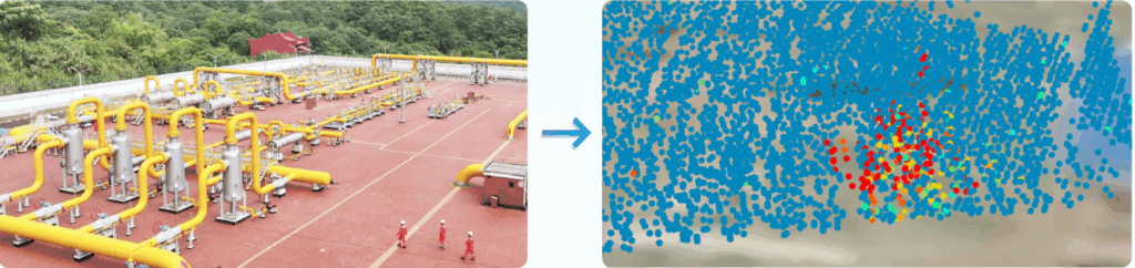
SSI offers multiple methane visualization layers:
These tools provide spatial clarity, helping analysts understand plume dispersion, concentration intensity, and leak severity.

All methane, positional, and imaging data can be streamed directly to:
This ensures that decision-makers receive critical leak information instantly.
The SSI interface can be embedded into clients’ existing control software or enterprise dashboards, enabling operators to integrate methane data with:

SSI dramatically enhances operational efficiency:
MetScan V1 captures high-resolution imagery and methane concentration data around:
With centimeter-level positioning, operators can identify specific equipment responsible for emissions while keeping UAVs safely outside restricted zones.
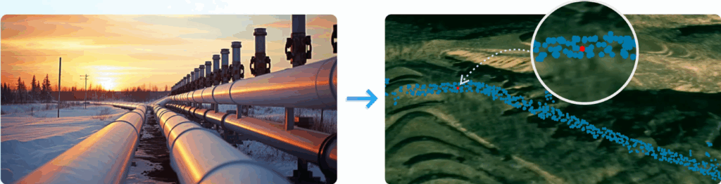
The system uses automated belt-type scanning and 50 Hz sampling to generate dense methane point clouds along pipeline routes. SSI instantly converts these into:
This supports efficient corridor inspections, anomaly verification, and regulatory-compliant reporting.
MetScan V1 offers unique capabilities for urban safety:
This makes it ideal for dense residential areas where gas incidents pose significant safety risks.
Soarability MetScan V1 is more than a methane detector—it is a complete, intelligent aerial inspection ecosystem. By combining long-range OP-TDLAS detection, precision imaging, 3D analytics, and real-time data streaming, it delivers unmatched efficiency and safety for operators in the natural gas, utilities, and industrial sectors.
Whether used for routine monitoring, emergency response, emissions reporting, or high-risk facility inspections, MetScan V1 empowers organizations to:
Reduce operational hazards
Accelerate leak detection
Improve environmental compliance
Strengthen infrastructure resilience
This UAV-based methane scanning solution sets a new standard for aerial gas inspection—bringing accuracy, intelligence, and scalability to the forefront of industrial safety.